Opitsvet Lake
| Opitsvet Lake | |
|---|---|
 Opitsvet Lake | |
| Location | Livingston Island, Antarctica |
| Coordinates | 62°43′37″S 60°09′12″W / 62.72694°S 60.15333°WCoordinates: 62°43′37″S 60°09′12″W / 62.72694°S 60.15333°W |
| Lake type | Glacial lake |
| Max. length | 420 metres (1,380 ft) |
| Max. width | 410 metres (1,350 ft) |
| Surface area | 11 hectares (27 acres) |

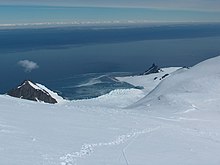

Opitsvet Lake (Bulgarian: езеро Опицвет, romanized: ezero Opitsvet, IPA: [ˈɛzɛro oˈpit͡svɛt]) is the lake extending 420 m in west–east direction and 410 m in north–south direction on the southeast coast of Rozhen Peninsula, Livingston Island in the South Shetland Islands, Antarctica. It has a surface area of 11 ha and is separated from the waters of Brunow Bay on the east and Bransfield Strait on the south by a 70 to 150 m wide strip of land.[1] The area was visited by early 19th century sealers.[2]
The feature is named after the settlement of Opitsvet and the eponymous marsh in Western Bulgaria.[1]
Location[]
Opitsvet Lake is situated at the base of Samuel Point and centred at 62°43′37″S 60°09′12″W / 62.72694°S 60.15333°W, which is 600 m east of Needle Peak and 2.78 km southwest of Vazov Point. Bulgarian mapping of the area in 2009 and 2017.
Maps[]
- L. Ivanov. Antarctica: Livingston Island and Greenwich, Robert, Snow and Smith Islands. Scale 1:120000 topographic map. Troyan: Manfred Wörner Foundation, 2009. ISBN 978-954-92032-6-4
- L. Ivanov. Antarctica: Livingston Island and Smith Island. Scale 1:100000 topographic map. Manfred Wörner Foundation, 2017. ISBN 978-619-90008-3-0
- Antarctic Digital Database (ADD). Scale 1:250000 topographic map of Antarctica. Scientific Committee on Antarctic Research (SCAR). Since 1993, regularly upgraded and updated
See also[]
Notes[]
- ^ a b Opitsvet Lake. SCAR Composite Gazetteer of Antarctica
- ^ L. Ivanov. General Geography and History of Livingston Island. In: Bulgarian Antarctic Research: A Synthesis. Eds. C. Pimpirev and N. Chipev. Sofia: St. Kliment Ohridski University Press, 2015. pp. 17–28
References[]
- Opitsvet Lake. SCAR Composite Gazetteer of Antarctica
- Bulgarian Antarctic Gazetteer. Antarctic Place-names Commission. (details in Bulgarian, basic data in English)
External links[]
- Opitsvet Lake. Adjusted Copernix satellite image
This article includes information from the Antarctic Place-names Commission of Bulgaria which is used with permission.
This Livingston Island location article is a stub. You can help Wikipedia by . |
- Bodies of water of Livingston Island
- Lakes of the South Shetland Islands
- Bulgaria and the Antarctic
- Livingston Island geography stubs