Orondo, Washington
Orondo | |
|---|---|
Unincorporated Community | |
| Orondo, Washington | |
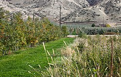 An apple orchard in the Orondo area. | |
| Motto(s): | |
| Coordinates: 47°37′33″N 120°13′31″W / 47.62583°N 120.22528°W | |
| Country | United States |
| State | Washington |
| County | Douglas |
| Elevation | 758 ft (231 m) |
| Population (2010) | |
| • Estimate (2017) | 1,995[3] |
| ZIP code | 98843 |
| Area code | 509 |

Orondo is an unincorporated community in Douglas County, Washington, United States, located alongside the eastern part of the Columbia River. It is part of the Wenatchee–East Wenatchee Metropolitan Statistical Area. The area is well known for its robust agriculture industry, and produce fruits such as apples, cherries and pears. The name was derived from a mythical Great Lake Indian and was first settled in the late 19th century by late Washington politician, John B. Smith.[4][5]
The Auvil Fruit Company is located in Orondo, which has introduce Granny Smiths, establishing M26 root stock, and fostering quality production of Fuji Apples in Washington state by the help of the founder, Grady Auvil.[6]
The town supports one 76 gas station/convenience store named the "Orondo Market Place",[7] a U.S. Post Office, an Elementary school, and a multitude of fruit stands along U.S. Highway 97. Desert Canyon Golf course is also located and features a restaurant and accommodations.
In 2018, the Subway restaurant that was located in the "Orondo Market Place" closed down
According to United States Census, the population is estimated to be 1995 with a marginal error of 338 as of 2017.[8]
Parks[]
Daroga State Park: A 127-acre camping park with 1.5 miles of Columbia River shoreline on the elevated edge of the desert scab-lands. First established as an orchard/ranch site in 1928, the name derived as the first letters of Auvil brother: Dave, Robert, and Grandy. A new peach was developed cataloged as the Daroga Peach. In 1981, Grady Auvil sold the property to the state of Washington and is now currently owned by the Chelan County PUD but operated by Washington State Parks.[9]
Orondo River Park: established in 1972, the park has been a recreational site since 1976. The port of Douglas and Chelan County PUD own property within the park boundaries.[10]
In October 2017, the port of Douglas has asked the Chelan PUD take over operation and ownership of the facility due to the park losing money for years.[11][12]
Education[]
The town has one school district that operates the preschool, elementary and middle school.[13]
The district is a "non-high" school district and has no high school opportunity in the town. As a result, the neighboring schools provide high school education for Freshman through Senior students.[14]
History[]
1887, the townsite of Orondo was established by J.B Smith.
1888, Smith donated a plot of land to attract more settlers to Orondo
Agricultural Industry[]
This section is empty. You can help by . (February 2019) |
Businesses[]
This section is empty. You can help by . (February 2019) |
Environment[]
This section is empty. You can help by . (February 2019) |
Climate[]
| hideClimate data for Orondo, Washington | |||||||||||||
|---|---|---|---|---|---|---|---|---|---|---|---|---|---|
| Month | Jan | Feb | Mar | Apr | May | Jun | Jul | Aug | Sep | Oct | Nov | Dec | Year |
| Record high °F (°C) | 55 (13) |
62 (17) |
76 (24) |
82 (28) |
97 (36) |
102 (39) |
107 (42) |
103 (39) |
100 (38) |
87 (31) |
70 (21) |
60 (16) |
107 (42) |
| Average high °F (°C) | 35 (2) |
42 (6) |
54 (12) |
63 (17) |
71 (22) |
78 (26) |
86 (30) |
87 (31) |
78 (26) |
63 (17) |
45 (7) |
34 (1) |
61 (16) |
| Average low °F (°C) | 22 (−6) |
25 (−4) |
31 (−1) |
36 (2) |
42 (6) |
48 (9) |
53 (12) |
53 (12) |
46 (8) |
37 (3) |
29 (−2) |
21 (−6) |
37 (3) |
| Record low °F (°C) | −13 (−25) |
−9 (−23) |
14 (−10) |
26 (−3) |
30 (−1) |
33 (1) |
42 (6) |
37 (3) |
27 (−3) |
11 (−12) |
2 (−17) |
−16 (−27) |
−16 (−27) |
| Average precipitation inches (mm) | 1.82 (46) |
1.37 (35) |
1.10 (28) |
0.68 (17) |
0.90 (23) |
0.83 (21) |
0.32 (8.1) |
0.26 (6.6) |
0.41 (10) |
0.96 (24) |
2.14 (54) |
2.39 (61) |
13.18 (333.7) |
| Source: [15] | |||||||||||||
Literature[]
In East of the Mountains (1999), Orondo is mentioned when one of two Spanish speaking brothers on a bus asked Catherine Donnelly, where they are and wondering how long till they arrive at Orondo. The brothers then mentioned that they work at Orondo picking apples.[16]
References[]
- ^ Steele, Richard F.; Rose, Arthur P. (1904). "An Illustrated History of the Big Bend Country: Embracing Lincoln, Douglas, Adams and Franklin Counties, State of Washington".
- ^ Kane, Joseph Nathan; Alexander, Gerard L. (1979). Nicknames and Sobriquets of U.S. Cities, States, and Counties. ISBN 9780810812550.
- ^ "Explore Census Data".
- ^ Majors, Harry M. (1975). Exploring Washington. Van Winkle Publishing Co. p. 96. ISBN 978-0-918664-00-6.
- ^ Meany, Edmond S. (1923). Origin of Washington geographic names. Seattle: University of Washington Press. p. 202.
- ^ "Auvil Fruit Company | Premium Fruit Grower". Auvil Fruit Company | Premium Fruit Grower. Retrieved 2019-01-31.
- ^ "21318 Hwy 97, Orondo, WA 98843". LoopNet. Retrieved 2016-06-02.
- ^ "Explore Census Data". data.census.gov. Retrieved 2019-11-26.
- ^ "Daroga State Park | Washington State Parks and Recreation Commission". parks.state.wa.us. Retrieved 2019-11-25.
- ^ "Orondo River Park". www.chelanpud.org. Retrieved 2019-11-25.
- ^ "Chelan County PUD is building 2018 budget with no electric rate increase". www.chelanpud.org. Retrieved 2019-11-25.
- ^ Hair, Steve (2018-06-05). "DOUGLAS PORT APPEALS TO PUD TO TAKE OVER ORONDO PARK". NCWLIFE. Retrieved 2019-11-25.
- ^ "Orondo School District / Homepage" Check
|url=value (help). http. Retrieved 2019-11-25. - ^ "High School Services / Program" Check
|url=value (help). http. Retrieved 2019-11-25. - ^ "weather.com". Retrieved November 15, 2011.
- ^ Guterson, David. (2000). East of the mountains. London: Bloomsbury. ISBN 0-7475-4508-1. OCLC 42578805.
| show Municipalities and communities of Douglas County, Washington, United States |
|---|

| show Authority control |
|---|
Coordinates: 47°37′33″N 120°13′31″W / 47.62583°N 120.22528°W
- Unincorporated communities in Washington (state)
- Unincorporated communities in Douglas County, Washington
- Wenatchee–East Wenatchee metropolitan area
- Washington (state) populated places on the Columbia River