Oropesa, Spain
Oropesa | |
|---|---|
 | |
 Flag | |
 Oropesa Location in Spain | |
| Coordinates: 39°55′N 5°11′W / 39.917°N 5.183°WCoordinates: 39°55′N 5°11′W / 39.917°N 5.183°W | |
| Country | |
| Autonomous community | |
| Province | Toledo |
| Comarca | |
| Judicial district | Talavera de la Reina |
| Government | |
| • Alcalde | Juan Antonio Morcillo Reviriego (2007) |
| Area | |
| • Total | 337 km2 (130 sq mi) |
| Elevation | 425 m (1,394 ft) |
| Population (2018)[1] | |
| • Total | 2,658 |
| • Density | 7.9/km2 (20/sq mi) |
| Demonym(s) | Oropesano, na |
| Time zone | UTC+1 (CET) |
| • Summer (DST) | UTC+2 (CEST) |
| Postal code | 45560 |
| Dialing code | 925 |
| Official language(s) | Castillian |
| Website | Official website |

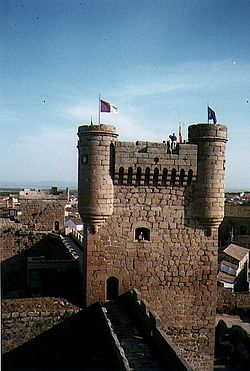
Oropesa is a Spanish town in the province of Toledo. The town of 2,872 is famous for its castle-turned-parador, which was built in 1402. The parador was formerly the residence of the Toledo family of nobles. This includes Francisco de Toledo, Count of Oropesa, who became the Viceroy of Peru.
The town has a yearly celebration in April called "Jornadas Medievales", or "Medieval Days", which plays off the presence of the Castle in Oropesa.
References[]
- ^ Municipal Register of Spain 2018. National Statistics Institute.
See also[]
| show Municipalities in the province of Toledo |
|---|
| show Authority control |
|---|
This article about a location in the autonomous community of Castilla–La Mancha, Spain is a stub. You can help Wikipedia by . |
Categories:
- Municipalities in the Province of Toledo
- Castilla–La Mancha geography stubs