Oshtorinan
Oshtorinan
اشترينان | |
|---|---|
City | |
 Oshtorinan | |
| Coordinates: 34°01′00″N 48°38′40″E / 34.01667°N 48.64444°ECoordinates: 34°01′00″N 48°38′40″E / 34.01667°N 48.64444°E | |
| Country | |
| Province | Lorestan |
| County | Borujerd |
| Bakhsh | Oshtorinan |
| Population (2016 Census) | |
| • Total | 5,520 [1] |
| Time zone | UTC+3:30 (IRST) |
| • Summer (DST) | UTC+4:30 (IRDT) |
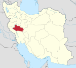
Oshtorinan (Persian: اشترينان, oŝtorinān, Ashtarian, also Romanized as Oshtorīnān and Oshtornīān)[2] is a town and the capital of Oshtorinan District, in Borujerd County, Lorestan Province, Iran. At the 2006 census, its population was 5,264, in 1,408 families.[3] The city and district is populated by Kurds.[4]
Oshtorinan has a cold climate and is an agricultural centre. Oshtorinan is located in the western region of Iran between the cities of Borujerd, Malayer, and Nahavand. It is 15 km north-west of Borujerd and historically has been used as a caravanserai for travelling from Borujerd to Hamedan, and from Isfahan to Baghdad.
References[]
- ^ "Statistical Center of Iran > Home".
- ^ Oshtorinan can be found at GEOnet Names Server, at this link, by opening the Advanced Search box, entering "-3823564" in the "Unique Feature Id" form, and clicking on "Search Database".
- ^ "Census of the Islamic Republic of Iran, 1385 (2006)" (Excel). Statistical Center of Iran. Archived from the original on 2011-11-11.
- ^ "سیمای عشایر استان لرستان" (PDF) (in Persian). تهیه وتنظیم : اداره مطالعات وبرنامه ریزی: 3. Retrieved 26 April 2020. Cite journal requires
|journal=(help)
Categories:
- Towns and villages in Borujerd County
- Cities in Lorestan Province
- Kurdish settlements in Iran
- Borujerd County geography stubs

