Ouésso
Ouésso | |
|---|---|
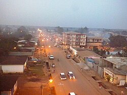 Ouésso at night (2015) | |
 Seal | |
 Ouésso Location in the Republic of the Congo | |
| Coordinates: 1°36′49″N 16°03′06″E / 1.61361°N 16.05167°E | |
| Country | |
| Region | Sangha Region |
| District | Ouésso District |
| Area | |
| • Total | 5 km2 (2 sq mi) |
| Elevation | 340 m (1,120 ft) |
| Population (2012) | |
| • Total | 31,062 |
| • Density | 6,200/km2 (16,000/sq mi) |

Ouésso is a town in the northern Republic of the Congo, lying on the Sangha River and surrounded by rainforest. It is linked by ferry with Brazzaville and is known for the pygmy people who live nearby. It is the capital of the Sangha Region.
It is served by Ouésso Airport.
Climate[]
Ouésso has a tropical monsoon climate (Köppen climate classification Am), bordering on a tropical rainforest climate (Af).
| Climate data for Ouesso | |||||||||||||
|---|---|---|---|---|---|---|---|---|---|---|---|---|---|
| Month | Jan | Feb | Mar | Apr | May | Jun | Jul | Aug | Sep | Oct | Nov | Dec | Year |
| Average high °C (°F) | 31 (88) |
32 (89) |
32 (90) |
33 (91) |
31 (88) |
30 (86) |
29 (85) |
29 (85) |
30 (86) |
31 (87) |
31 (87) |
30 (86) |
31 (87) |
| Average low °C (°F) | 21 (69) |
21 (69) |
22 (71) |
22 (71) |
22 (71) |
21 (70) |
21 (69) |
21 (69) |
21 (69) |
21 (69) |
21 (69) |
20 (68) |
21 (70) |
| Average rainfall mm (inches) | 56 (2.2) |
79 (3.1) |
150 (5.9) |
130 (5) |
150 (6) |
120 (4.6) |
79 (3.1) |
150 (6.1) |
220 (8.7) |
230 (8.9) |
150 (6) |
84 (3.3) |
1,598 (62.9) |
| Source: Weatherbase [1] | |||||||||||||
Timeline[]
This section needs expansion. You can help by . (June 2008) |
2007[]
In April 2007, a Korean consortium proposed to build a railway to Ouésso from Brazzaville, in exchange for a concession to harvest timber.[2]
References[]
- ^ "Weatherbase: Historical Weather for Ouesso, Republic of Congo". Weatherbase. 2011. Retrieved on November 24, 2011.
- ^ Ouésso railway
Coordinates: 01°36′49″N 16°03′06″E / 1.61361°N 16.05167°E
This Republic of the Congo location article is a stub. You can help Wikipedia by . |
Categories:
- Sangha Department (Republic of the Congo)
- Populated places in the Republic of the Congo
- Cameroon–Republic of the Congo border crossings
- Republic of the Congo geography stubs