Outer Subcarpathia
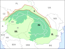

Outer Subcarpathia (Polish: Podkarpacie Zewnętrzne; Ukrainian: Прикарпаття, Prykarpattia; Czech: Vněkarpatské sníženiny; German: Karpatenvorland) denotes the depression area at the outer (western, northern and eastern) base of the Carpathian arc, including foothills of the Outer Western Carpathians and Outer Eastern Carpathians. It stretches from northeastern Austria, through eastern Czech Republic, southern Poland, western Ukraine and northeastern Romania.[1]
The opposite foothill regions on the inner side of the Carpathian arc are known as Inner Subcarpathia, transitioning further to the Pannonian Basin.[2]
Geography[]

1. Outer Western Carpathians
2. Inner Western Carpathians
3. Outer Eastern Carpathians
4. Inner Eastern Carpathians
5. Southern Carpathians
6. Western Romanian Carpathians
7. Transylvanian Plateau
8. Serbian Carpathians
The western end is marked by the (northern) Vienna Basin, separating it from the Eastern Alpine Foreland. The adjacent hilly landscape of the Lower Austrian Weinviertel region with its extensive loess layers border on the limestone rock formations of the South-Moravian Carpathians.
In the Czech Republic, the depression is situated on the outskirts of the White Carpathians in Moravia, including the Pálava Protected Landscape Area. In Poland they stretch along the Lesser Poland Voivodeship to the Podkarpackie Voivodeship, part of the Galicia historic region that leads to Ukraine (Lviv, Ivano-Frankivsk and Chernivtsi Oblast) and the Dniester Basin.
In Romania, the depression ends east of the Carpathian arc on the upper Moldova River within the Bukovina and Moldavia regions, bordering on the Wallachian Plain in the south.
Subdivisions[]
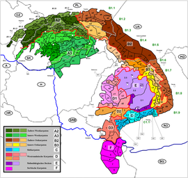
- (DE: Weinviertler Hügelland; CZ: Weinviertelská pahorkatina; PL: Pogórze Weinviertel) + Dyje-Svratka Valley (DE: Thaya-Schwarza-Talsenke; CZ: Dyjsko-svratecký úval) → A1.1
- Vyškov Gate (CZ: Vyškovská brána) → A1.2
- (CZ: Hornomoravský úval) → A1.3
- Moravian Gate (CZ: Moravská brána) → A1.4
- Ostrava Basin (CZ: Ostravská pánev, PL: Kotlina Ostrawska) → A1.5
- Oświęcim Basin (PL: Kotlina Oświęcimska) → A1.6
- Kraków Gate (PL: Brama Krakowska) → A1.7
- Sandomierz Basin (PL: Kotlina Sandomierska) + (PL: Płaskowyż Sańsko-Dniestrzański; UA: Сянсько-Дністровська рівнина) → B1.1
- (UA: Верхньодністровська улоговина) → B1.2
- (PL: Wysoczyzna Drohobycka; UA: Дрогобицька височина) → B1.3
- (UA: Придністровська рівнина) → B1.4
- (UA: Покутська височина) → B1.5
- (UA: Буковинське Прикарпаття; RO: Podișul Bucovinei) + Suceava Plateau (RO: Podișul Sucevei) → B1.6
- (RO: Culoarul Moldova-Siret) → B1.7
- Moldavian Subcarpathians (RO: Subcarpații Moldovei) → B1.8
- (RO: Subcarpații Munteniei) → B1.9
- (RO: Subcarpații Getici) + (RO: Podișul Getic) → C1.1
See also[]
- Divisions of the Carpathians
- South-Moravian Carpathians
- Central Moravian Carpathians
- Slovak-Moravian Carpathians
- Carpathian Flysch Belt
- Western Beskids
- West Beskidian Foothills
- Central Beskidian Piedmont
- Central Beskids
- Podkarpackie Voivodeship
- Wooded Carpathians
- Ukrainian Carpathians
- Eastern Beskids
- Eastern Carpathian Foothills
- Prykarpattia
- Pokuttya
- Bukovinian Subcarpathia
- Moldavian Subcarpathia
- Moldavian-Muntenian Carpathians
- Romanian Carpathians
References[]
| Wikimedia Commons has media related to Divisions of the Subcarpathians. |
External links[]
| Wikimedia Commons has media related to Outer Carpathian depressions. |
| hide Divisions, Groups, and Ranges of the Carpathian Mountains | ||||||
|---|---|---|---|---|---|---|
| Western Carpathians |
|  | ||||
| Eastern Carpathians |
| |||||
| Southern Carpathians | ||||||
| Western Romanian Carpathians | ||||||
| Serbian Carpathians | ||||||
| Adjacent regions |
| |||||
| Grouping by country | ||||||
- Carpathians