Oxbow Dam
| Oxbow Dam | |
|---|---|
 | |
| Official name | Oxbow Dam |
| Location | Hells Canyon, Adams County, Idaho / Baker County, Oregon, USA |
| Coordinates | 44°58′15″N 116°50′04″W / 44.97083°N 116.83444°WCoordinates: 44°58′15″N 116°50′04″W / 44.97083°N 116.83444°W |
| Opening date | 1961[1] |
| Operator(s) | Idaho Power Company |
| Dam and spillways | |
| Impounds | Snake River |
| Height | 175 feet (53 m) |
| Reservoir | |
| Creates | Oxbow Reservoir |
| Total capacity | 58,200 acre-feet (71,800,000 m3) |
| Catchment area | 73,300 square miles (190,000 km2) |
| Surface area | 1,150 acres (470 ha) |
| Power Station | |
| Installed capacity | 190 megawatts (250,000 hp) |
| Annual generation | 1,047 gigawatt-hours (3,770 TJ) |

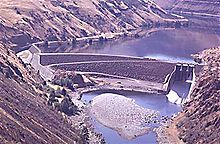
Oxbow Dam is a hydroelectric run-of-the-river rockfill dam on the Snake River on the Idaho-Oregon border, in Hells Canyon (river mile 273). Completed in 1961,[1] it is part of the Hells Canyon Project that also includes Hells Canyon Dam and Brownlee Dam, built and operated by Idaho Power Company.
The dam's powerhouse contains four generating units with a total nameplate capacity of 190 megawatts (250,000 hp).
Lacking passage for migrating salmon, the three Hells Canyon Project dams blocked access by anadromous salmonids to a stretch of the Snake River drainage basin from Hells Canyon Dam up to Shoshone Falls, which naturally prevents any upstream fish passage to the upper Snake River basin.
Heliport[]
Oxbow Heliport (FAA LID: OR83) is a private 100-by-100-foot (30 by 30 m), turf heliport owned by Idaho Power.[2]
See also[]

Notes[]
- ^ a b "Oxbow completed". Lewiston Morning Tribune. (Idaho). (photo). November 30, 1961. p. 1, section 2.
- ^ FAA 5010 for OR83
References[]
- Oxbow Dam, Columbia Basin Research
- Oxbow Dam, Northwest Power and Conservation Council
- Oxbow Dam, Idaho Power
External links[]
| Wikimedia Commons has media related to Oxbow Dam. |
- Resources for this airport:
- FAA airport information for OR83
- AirNav airport information for OR83
- FlightAware airport information and live flight tracker
- SkyVector aeronautical chart for OR83
- Dams completed in 1961
- Buildings and structures in Adams County, Idaho
- Buildings and structures in Baker County, Oregon
- Dams in Idaho
- Dams in Oregon
- Idaho Power dams
- Dams on the Snake River
- Rock-filled dams
- 1961 establishments in Idaho
- 1961 establishments in Oregon