Padang Panjang
Padang Panjang
ڤادڠ ڤنجڠ | |
|---|---|
 A traditional Minangkabau rumah gadang ("big house") in Padang Panjang | |
 Coat of arms | |
| Nickname(s): Egypte van Andalas | |
| Motto(s): Padang Panjang Kota Serambi Mekah (Indonesian: Padang Panjang The Courtyard of Mecca) | |
 Location within West Sumatra | |
 Padang Panjang Location in West Sumatra and Indonesia | |
| Coordinates: 0°27′S 100°25′E / 0.450°S 100.417°ECoordinates: 0°27′S 100°25′E / 0.450°S 100.417°E | |
| Country | |
| Province | |
| Government | |
| • Mayor | Fadly Amran |
| • Vice Mayor | Asrul |
| Area | |
| • Total | 23.00 km2 (8.88 sq mi) |
| Population (2020) | |
| • Total | 54,421 |
| • Density | 2,400/km2 (6,100/sq mi) |
| [1] | |
| Time zone | UTC+7 (Indonesia Western Time) |
| Area code | (+62) 752 |
| Website | portal |


Padang Panjang (sometimes written as Padangpanjang, spelled as Padang Pandjang in Dutch East Indies era, literally long field, Jawi: ڤادڠ ڤنجڠ), is located in the cool highlands of West Sumatra, inland from the provincial capital Padang. It sits on a plateau beneath the volcanoes Mount Marapi and Mount Singgalang. It has an area of 23.0 km² and a population at the 2010 Census of 47,008;[2] the latest estimate (as at mid 2020) is 54,421. It is located at 0°27′S 100°25′E / 0.450°S 100.417°E.
Home to a famous performing arts conservatorium, Sekolah Tinggi Seni Indonesia (STSI or "Indonesian College of the Art") Padang Panjang, the town stretches up the hill from the marketplace and central mosque, to the soccer field and bus terminal on up to STSI. The main road through Padang Panjang links coastal Padang and the highland capital, Bukittinggi.
The town is also home to the Minangkabau Cultural Documentation and Information Center (Pusat Dokumentasi dan Informasi Kebudayaan Minangkabau - PDIKM).
Administrative Districts[]
Padang Panjang city consists of two districts (kecamatan), tabulated below with their areas and population totals from the 2010 Census[3] and the official estimates for mid 2018.[4] The table also includes the number of administrative villages (urban kelurahan) in each district, and its postal codes.
| Name | Area in km2 |
Population Census 2010[5] |
Population Estimate mid 2018[6] |
Number of villages |
Post codes |
|---|---|---|---|---|---|
| Padang Panjang Barat (West Padang Panjang) |
9.75 | 27,637 | 29,177 | 8 | 27111 -27118 |
| Padang Panjang Timur (East Padang Panjang) |
13.25 | 19,371 | 23,817 | 8 | 27121 -27128 |
| Totals | 23.00 | 47,008 | 52,994 | 16 |
The totals in 2018 included 26,402 males and 26,592 females.
Administrative villages (kelurahan)[]
West Padang Panjang District consists of the 8 villages of Silaing Bawah, Silaing Atas, Pasar Usang, Kampung Manggis, Tanah Hitam, Pasar Baru, Bukit Surungan and Balai-Balai. East Padang Panjang District comprises the 8 villages of Koto Panjang, Koto Katik, Ngalau, Ekor Lubuk, Sigando, Ganting, Guguk Malintang and Tanah Pak Lambik.
Town without cigarette advertisements[]
Since 2008, Padangpanjang is the only town/city in Indonesia without cigarette advertisements. In public areas, public transport, and youth facilities, smoking is prohibited. In other areas, smoking is restricted to smoking rooms. In 2014, some pulmonologists wished to transfer to other towns, because of the lack of patients.[7]
Notable people[]
- Arifin Bey, diplomat, editor, teacher, author
Gallery[]

Indonesian Art High School (STSI) in Padang Panjang
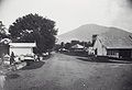
Street scenery in Padang Panjang in colonial times, with Mount Marapi

Earthquake in 1926

Minangkabau mosque in Padang Panjang year 1912

Europeans sitting before the house of the resident of Padang Panjang in 1900
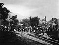
Opening of the railway line in Padang Panjang in 1895


References[]
- ^ Badan Pusat Statistik, Jakarta, 2020.
- ^ Biro Pusat Statistik, Jakarta, 2011.
- ^ Biro Pusat Statistik, Jakarta, 2011.
- ^ Badan Pusat Statistik, Jakarta, 2020.
- ^ Biro Pusat Statistik, Jakarta, 2011.
- ^ Badan Pusat Statistik, Jakarta, 2020.
- ^ "Kisah Kota Padang Panjang Berani Melawan Rokok". June 3, 2014.
External links[]
 Padang Panjang travel guide from Wikivoyage
| Wikimedia Commons has media related to Padang Panjang. |

| Authority control |
|
|---|
This West Sumatra location article is a stub. You can help Wikipedia by . |
- Cities in West Sumatra
- Populated places in West Sumatra
- Sumatra geography stubs