Pasaman Regency
Pasaman Regency
Kabupaten Pasaman | |
|---|---|
 Coat of arms | |
| Motto(s): Saiyo | |
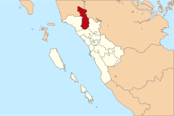 Location within West Sumatra | |
| Coordinates: 0°10′00″N 100°07′01″E / 0.166667°N 100.117°E | |
| Country | Indonesia |
| Province | West Sumatra |
| Regency seat | Lubuk Sikaping |
| Government | |
| • Regent | Yusuf Lubis |
| • Vice Regent | Atos Pratama |
| Area | |
| • Total | 3,947.63 km2 (1,524.19 sq mi) |
| Population (2020 Census)[1] | |
| • Total | 299,851 |
| • Density | 76/km2 (200/sq mi) |
| Time zone | UTC+7 (IWST) |
| Area code | (+62) 753 |
| Website | pasamankab.go.id |


Pasaman Regency is a regency (kabupaten) of West Sumatra, Indonesia. It has an area of 3,947.63 square kilometres (1,524.19 sq mi) and had a population of 252,981 at the 2010 Census[2] and 299,851 at the 2020 Census.[3] The regency seat is the town of Lubuk Sikaping.
Pasaman is located in the north-east of West Sumatera. The town of Bonjol, birthplace of Tuanku Imam Bonjol, is notable for being the area where the Trans-Sumatran Highway crosses the equator. Although the majority tribe in West Sumatra is Minangkabau, in Pasaman there is another big tribe, that is Mandailing from North Sumatra, so Pasaman means "equality" between two tribe (Pasaman is in Minangkabau language, in Indonesian is "Persamaan"), like the first Vice-Regent of Pasaman was H. Ahmad Dahlan Nasution from Duo Koto, King of (kingdom of Mandailing in Pasaman).
Administrative districts[]
Pasaman Regency is divided into twelve districts (kecamatan), listed below with their areas and their populations at the 2010 Census[4] and the 2020 Census.[5] The table also includes the location of the district administrative centres, and the number of administrative villages (rural desa and urban kelurahan) in each district.
| Name | Area in km2 |
Pop'n Census 2010[6] |
Pop'n Census 2020[7] |
Admin centre |
No. of vill. |
Post code |
|---|---|---|---|---|---|---|
| Sungai Beremas (a) | 440.48 | 21,345 | 27,556 | Air Bangih | 15 | 26573 |
| Tigo Nagari | 352.92 | 22,997 | 29,943 | Ladang Panjung | 3 | 26358 |
| Bonjol | 194.32 | 23,184 | 26,282 | Parit | 4 | 26381 |
| Simpang Alahan Mati | 69.56 | 10,580 | 12,384 | Alahan Mati | 2 | 26382 |
| Lubuk Sikaping | 346.50 | 43,746 | 51,092 | Lubuk Sikaping | 6 | 26318 |
| Dua Koto | 360.63 | 24,602 | 28,709 | Simpang Andilan | 2 | 26311 |
| Panti | 194.50 | 35,412 | 34,519 | Panti | 3 | 26351 |
| Padang Gelugur | 178.40 | 21,341 | 32,724 | Tapus | 4 | 26352 |
| Rao | 236.18 | 22,168 | 26,041 | Rao | 2 | 26355 |
| Rao Utara | 598.63 | 10,293 | 12,052 | Koto Rajo | 3 | 26357 |
| Rao Selatan | 338.98 | 21,600 | 26,192 | Lansek Kadok | 2 | 26356 |
| Mapat Tunggul | 605.29 | 8,846 | 10,165 | Lubuk Gadang | 3 | 26353 |
| Mapat Tunggul Selatan | 471.72 | 8,530 | 9,748 | Silayang | 3 | 26354 |
| Totals | 3,947.63 | 252,981 | 299,851 | Lubuk Sikaping | 37 |
References[]

Coordinates: 0°10′00″N 100°07′01″E / 0.166667°N 100.117°E
This West Sumatra location article is a stub. You can help Wikipedia by . |
- Sumatra geography stubs
- Regencies of West Sumatra