Pagórki, Warmian-Masurian Voivodeship
Pagórki | |
|---|---|
Village | |
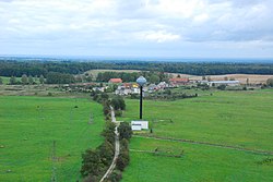 Village Pagórki with water tower and foundations for wind turbines of a future wind park. | |
 Pagórki | |
| Coordinates: 54°15′21″N 19°30′49″E / 54.25583°N 19.51361°E | |
| Country | |
| Voivodeship | Warmian-Masurian |
| County | Elbląg County |
| Gmina | Tolkmicko |


Pagórki [paˈɡurki] (German: Rehberg)[1] is a village in the administrative district of Gmina Tolkmicko, within Elbląg County, Warmian-Masurian Voivodeship, in northern Poland.[2] It lies approximately 8 kilometres (5 mi) south of Tolkmicko, 20 km (12 mi) north of Elbląg, and 84 km (52 mi) north-west of the regional capital Olsztyn.
Before 1772 the area was part of Kingdom of Poland, 1772-1945 Prussia and Germany (East Prussia).
History[]

It is not known when the village was founded. Most likely in May 1255 Dietrich von Grüningen gave land in Rehberg area with a size of 40 volok[3] to the Knights Hospitaller. Knights Hospitaller proceed and established a village in that area. Rehberg as a village exists from the fourteenth century. At the beginning of the Prussian period, that is after 1772, Rehberg received the right to establish a school. From June 1, 1800, the teacher, Kempowski, was working there. He received from the owners of the estate 42 thalers, five korzec (bushels)[4] of rye, barley, peas, free flats and fuel. Teacher Kempowski was paid a penny each week for each child at school. Such earnings were granted to him on June 4, 1800. by Scholten, manager of the Cadinen estate. The school in Rehberg was closed in 1823, and the children were assigned to the school in Cadinen, but they almost did not show up because of the large distance and often impassable roads.
References[]
| Wikimedia Commons has media related to Pagórki, Warmian-Masurian Voivodeship. |
- ^ "Former Territory of Germany" (in German). 2017-11-08.
- ^ "Central Statistical Office (GUS) - TERYT (National Register of Territorial Land Apportionment Journal)" (in Polish). 2008-06-01.
- ^ Obsolete Polish units of measurement. One volok equals about 18 hectares.
- ^ Obsolete Polish units of measurement. One korzec was from 10 to 501 litres depending on the actual definition.
| hide | ||
|---|---|---|
| Town and seat |  | |
| Villages | ||
Coordinates: 54°15′21″N 19°30′49″E / 54.25583°N 19.51361°E
This Elbląg County location article is a stub. You can help Wikipedia by . |
- Villages in Elbląg County
- Elbląg County geography stubs