Palacio del Gobernador
| Palacio del Gobernador | |
|---|---|
 Facade of the Palacio del Gobernador | |
 | |
| General information | |
| Town or city | Manila |
| Country | Philippines |
| Current tenants | Commission on Elections[1] Intramuros Administration |
| Completed | 1976 |
| Design and construction | |
| Architect | |
| Designations | NHCP marked structure |
| Website | |
| www | |
The Palacio del Gobernador (transl. Governor's Palace) is a government building located in Intramuros, Manila, Philippines. It is located southwest from Plaza de Roma[2] and built in its current form in 1976. At present, the building houses the Intramuros Administration, the Commission on Elections and the Home Development Mutual Fund National Capital Region Office. It also previously housed the Bureau of the Treasury until it relocated across Plaza de Roma to the Ayuntamiento de Manila.[when?]
The site of the present building was where the former residence of the governor-general during the Spanish Colonial Era was located until an earthquake destroyed it on June 3, 1863. Governor Rafaél de Echagüe y Bermingham moved to Malacañang after the earthquake.[3][4] The Malacañang Palace then became the governor-general's official residence.[5]
The building's exterior was used in the Chuck Norris film Delta Force 2: The Colombian Connection for a scene set in Rio de Janeiro during a Brazilian Carnaval parade.

References[]
- ^ Esmaquel II, Paterno R. (1 December 2017). "Comelec faces eviction from Palacio del Gobernador". Rappler. Retrieved 22 July 2021.
- ^ Torres, Jose Victor Z. (2005). Ciudad Murada: A Walk Through Historic Intramuros. Jointly published by Intramuros Administration and Vibal Publishing House. p. 59. ISBN 978-971-07-2276-1. Retrieved 22 July 2021.
- ^ Medina, Marielle (3 June 2020). "Did You Know: Palacio del Gobernador damaged in 1863 quake". INQUIRER.net. Retrieved 22 July 2021.
- ^ East Asian Cultural Studies (in Spanish). Centre for East Asian Cultural Studies. 1970. Retrieved 22 July 2021.
- ^ Former Palace of the Governors General (sic) (Marker on building facade). Palacio del Gobernador in Intramuros: Historical Research and Markers Committee. 1936.
Coordinates: 14°35′30″N 120°58′21″E / 14.5916°N 120.9725°E

Historic District of Manila | ||
| Buildings | 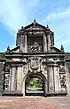 | |
| Fortifications | ||
| Parks, open spaces, and monuments | ||
| Museums | ||
| Education | ||
| Government | ||
| Destroyed | ||
| Administrators | ||
This article about a building or structure in the Philippines is a stub. You can help Wikipedia by . |
- Philippine building and structure stubs
- Buildings and structures in Intramuros
- Government buildings in the Philippines