Palu'e
This article needs additional citations for verification. (August 2013) |
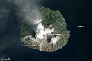
Palu'e Island (often referred to as Palu Island) is located north of Flores Island in the Flores Sea. It is part of Lesser Sunda Islands. Palu'e island is under the administrative region of Sikka regency of East Nusa Tenggara province, Indonesia.
The island has an area of 41 km² and population of 9,497 people (at the 2020 Census) in eight mountain villages. There are no roads or vehicles on the island. Palu'e can be reached from Maumere, a city in Flores, which takes six hours by wooden motorboat.
The language spoken on the island is the Malayo-Polynesian language Palu'e.
Rokatenda (Paluweh) volcano is located in the northern region of Palu'e. The volcano erupted on August 10, 2013 and killed six people, three adults and three children.[1][2]
References[]
- ^ "Victims of Indonesia volcano eruption refused to evacuate". CBC News. 10 August 2013.
- ^ "Evacuations from Indonesian island after deadly volcanic eruption". ABC. 12 August 2013.
See also[]
Coordinates: 8°19′27″S 121°42′36″E / 8.32417°S 121.71000°E

This East Nusa Tenggara location article is a stub. You can help Wikipedia by . |
- Lesser Sunda Islands
- Landforms of Flores Island (Indonesia)
- East Nusa Tenggara geography stubs