Paranaíba
Paranaíba | |
|---|---|
| The Municipality of Paranaíba | |
 | |
 Flag  Seal | |
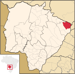 Location of Paranaíba | |
| Coordinates: 19°40′37″S 51°11′27″W / 19.67694°S 51.19083°WCoordinates: 19°40′37″S 51°11′27″W / 19.67694°S 51.19083°W | |
| Country | |
| Region | Central-West |
| State | |
| Founded | April 19, 1838 |
| Government | |
| • Mayor | José Garcia de Freitas (Zé Braquiara) (PDT) |
| Area | |
| • Total | 5,402.778 km2 (2,086.024 sq mi) |
| Elevation | 374 m (1,227 ft) |
| Population (2020 [1]) | |
| • Total | 42,276 |
| • Density | 7.16/km2 (18.5/sq mi) |
| Time zone | UTC-4 (UTC-4) |
| • Summer (DST) | UTC-3 (UTC-3) |
| HDI (2000) | 0.772 – medium[2] |
| Website | www.paranaiba.ms.gov.br/ |

Paranaíba is the easternmost municipality in the Brazilian state of Mato Grosso do Sul. Its population was 42,276 (2020) and its area is 5,402.778 km².
References[]
| Wikimedia Commons has media related to Paranaíba. |
| hide Authority control | |
|---|---|
| General |
|
| National libraries | |
This Mato Grosso do Sul, Brazil location article is a stub. You can help Wikipedia by . |
Categories:
- Municipalities in Mato Grosso do Sul
- Populated places established in 1838
- 1838 establishments in Brazil
- Mato Grosso do Sul geography stubs