Parikkala
Parikkala | |
|---|---|
Municipality | |
| Parikkalan kunta Parikkala kommun | |
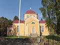
 Church of Saari | |
 Coat of arms | |
 Location of Parikkala in Finland | |
| Coordinates: 61°33′N 029°30′E / 61.550°N 29.500°ECoordinates: 61°33′N 029°30′E / 61.550°N 29.500°E | |
| Country | |
| Region | South Karelia |
| Sub-region | Imatra sub-region |
| Charter | 1635 |
| Government | |
| • Municipality manager | Alpo Kosunen |
| Area (2018-01-01)[1] | |
| • Total | 760.71 km2 (293.71 sq mi) |
| • Land | 592.93 km2 (228.93 sq mi) |
| • Water | 167.78 km2 (64.78 sq mi) |
| Area rank | 141st largest in Finland |
| Population (2021-03-31)[2] | |
| • Total | 4,634 |
| • Rank | 181st largest in Finland |
| • Density | 7.82/km2 (20.3/sq mi) |
| Population by native language | |
| • Finnish | 98.5% (official) |
| • Swedish | 0.1% |
| • Others | 1.4% |
| Population by age | |
| • 0 to 14 | 10.2% |
| • 15 to 64 | 49.1% |
| • 65 or older | 40.8% |
| Time zone | UTC+02:00 (EET) |
| • Summer (DST) | UTC+03:00 (EEST) |
| Municipal tax rate[5] | 20.5% |
| Climate | Dfc |
| Website | www.parikkala.fi |
Parikkala is a municipality of Finland located in the province of Southern Finland and is part of the South Karelia region, 97 kilometres (60 mi) from Lappeenranta and 139 kilometres (86 mi) from Joensuu. The municipality has a population of 4,634 (31 March 2021)[2] and covers an area of 760.71 square kilometres (293.71 sq mi) of which 167.78 km2 (64.78 sq mi) is water.[1] The population density is 7.82 inhabitants per square kilometre (20.3/sq mi).
The municipality is unilingually Finnish.
History[]
Parikkala is located around lake Simpele and it is a part of a countryside rich with hills and chains of ridges. Settlements and artifacts dated to the Stone Age and Bronze Age have been found in Parikkala. A permanent settlement was established around the 15th century. Many demarcations had a significant impact to Parikkala's development from the Treaty of Nöteborg on August 12, 1323 to peace treaties signed in 1947 with the Soviet Union; for example, in the Treaty of Nystad from 1721, which in practice defined roughly Finland's current border with Russia, Parikkala remained the only current Finnish municipality on the Russian side before the formation of the Grand Duchy of Finland.[6] After World War II, one third (199.3 km²) of Parikkala's area was handed over to the Soviet Union. The Orthodox Church has been very influential in this area since the middle ages. Later, Parikkala has become known for its many dairies. Parikkala became independent in 1617. In 2004, three municipalities (Parikkala, Saari and Uukuniemi) merged to form one municipality called Parikkala.

Education[]
A comprehensive school, one of the first rural schools in Karelia of Ladoga, was founded in 1907. In 1910 the first three-class school building was built; later it expanded to include a gymnasium, hall and kitchen.[clarification needed] A grand piano was provided in the hall, and Finnish artists Toivo Kuula and Oskar Merikanto held their concerts there when visiting Parikkala. Upper secondary school started in the year 1940 and the first class graduated in 1943. The largest number of pupils was in the 1950s, when over 500 pupils attended school there.
Traveling and routes[]
Parikkala is located on the main railway line from Helsinki to Joensuu. A railway station is located in the middle of Parikkala village center. Traveling time is about three and half hours from Helsinki, and all passenger trains stop at Parikkala. The city of Imatra is about 60 km south of Parikkala.
Gallery[]

Orthodox road cross on the site of a historical Orthodox village.
The Lutheran church of Uukuniemi.
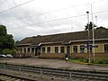
The Parikkala railway station.

The building of the newspaper Parikkalan-Rautjärven Sanomat in Parikkala.
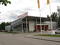
Tokmanni discount store in Parikkala.

The Sculpture Park of Parikkala.

Old coat of arms of Parikkala


References[]
- ^ Jump up to: a b "Area of Finnish Municipalities 1.1.2018" (PDF). National Land Survey of Finland. Retrieved 30 January 2018.
- ^ Jump up to: a b "Preliminary population structure by area, 2021M01*-2021M03*". StatFin (in Finnish). Statistics Finland. Retrieved 2 May 2021.
- ^ "Population according to language and the number of foreigners and land area km2 by area as of 31 December 2008". Statistics Finland's PX-Web databases. Statistics Finland. Retrieved 29 March 2009.
- ^ "Population according to age (1-year) and sex by area and the regional division of each statistical reference year, 2003-2020". StatFin. Statistics Finland. Retrieved 2 May 2021.
- ^ "List of municipal and parish tax rates in 2021" (PDF). Tax Administration of Finland. 1 December 2020. Retrieved 10 April 2021.
- ^ YLE: Rajakivestä löytyi "hymiö", jonka alkuperää ei tiedetä – kyseessä voi olla 300 vuotta vanha ruotsalaisvitsi (in Finnish)
External links[]
 Media related to Parikkala at Wikimedia Commons
- Municipality of Parikkala
- Beaches
- goSaimaa.com – travel information
- Siikalahti Wetland
- Parikkalan Urheilijat – Athletes Club
- Business Owners of Parikkala
| Municipalities |  | |
|---|---|---|
| Former municipalities | ||
| Authority control |
|
|---|
This Southern Finland location article is a stub. You can help Wikipedia by . |
- Parikkala
- Populated places established in 1635
- 1635 establishments in Sweden
- Southern Finland Province geography stubs