Parry Peak
| Parry Peak | |
|---|---|
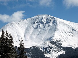 View of Parry Peak from Mary Jane Mountain | |
| Highest point | |
| Elevation | 13,397 ft (4,083 m)[1][2] |
| Prominence | 1,720 ft (524 m)[2] |
| Isolation | 9.46 mi (15.22 km)[2] |
| Listing |
|
| Coordinates | 39°50′17″N 105°42′48″W / 39.8380428°N 105.7133381°WCoordinates: 39°50′17″N 105°42′48″W / 39.8380428°N 105.7133381°W[3] |
| Naming | |
| Etymology | Charles Christopher Parry |
| Geography | |
 Parry Peak Colorado | |
| Location | Clear Creek and Grand counties, Colorado, U.S.[3] |
| Parent range | Front Range[2] |
| Topo map | USGS 7.5' map Empire, Colorado |

Parry Peak, elevation 13,397 ft (4,083 m), is a summit in the Front Range of central Colorado. The peak is on the continental divide southeast of Winter Park in the Arapahoe National Forest. The name honors Charles Christopher Parry, a botanist who made extensive studies of the Colorado mountain flora in the 1860s. It is one of the 637 thirteeners (peaks over 13,000 ft elevation) in the state of Colorado and lies along the Continental Divide Trail.
Parry Peak is also the highest peak of the James Group of the Front Range of Colorado.
See also[]
- List of mountain peaks of North America
- List of mountain peaks of the United States
- List of mountain peaks of Colorado
- List of mountain peaks of the United States
References[]
- ^ The elevation of Parry Peak includes an adjustment of +1.763 m (+5.78 ft) from NGVD 29 to NAVD 88.
- ^ Jump up to: a b c d "Parry Peak, Colorado". Peakbagger.com. Retrieved October 21, 2014.
- ^ Jump up to: a b "Parry Peak". Geographic Names Information System. United States Geological Survey. Retrieved October 21, 2014.
External links[]
Parry Peakat Wikipedia's sister projects
 Definitions from Wiktionary
 Media from Wikimedia Commons
 News from Wikinews
 Quotations from Wikiquote
 Texts from Wikisource
 Textbooks from Wikibooks
 Resources from Wikiversity
- Parry Peak on 13ers.com
- Parry Peak on listsofjohn.com
- Parry Peak on peakery.com
- Parry Peak on summitpost.org
| show |
|---|
| show |
|---|
| show |
|---|

This Colorado state location article is a stub. You can help Wikipedia by . |
Categories:
- Mountains of Colorado
- Mountains of Clear Creek County, Colorado
- Mountains of Grand County, Colorado
- North American 4000 m summits
- Colorado geography stubs