Parzymiechy
Parzymiechy | |
|---|---|
Village | |
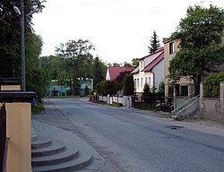 Central part of the village | |
 Parzymiechy | |
| Coordinates: 51°2′N 18°44′E / 51.033°N 18.733°E | |
| Country | |
| Voivodeship | Silesian |
| County | Kłobuck |
| Gmina | Lipie |
| Highest elevation | 256.8 m (842.5 ft) |
| Lowest elevation | 219.0 m (718.5 ft) |
| Population | 715 |
| Time zone | UTC+1 (CET) |
| • Summer (DST) | UTC+2 (CEST) |

Parzymiechy [paʐɨˈmjɛxɨ] is a village in the administrative district of Gmina Lipie, within Kłobuck County, Silesian Voivodeship, in southern Poland.[1] It lies approximately 6 kilometres (4 mi) north-west of Lipie, 20 km (12 mi) north-west of Kłobuck, and 89 km (55 mi) north of the regional capital Katowice.
The village has a population of 715.
History[]
Parzymiechy was first mentioned in 1266.
In September 1939, during the German invasion of Poland, which started World War II, a battle was fought nearby. German troops burned the village on September 2, 1939 and murdered 75 Polish inhabitants, including 20 children (see Nazi crimes against the Polish nation).[2]
Transport[]
Main road connections from the Parzymiechy include connection with Praszka (to the west) and Działoszyn (to the north-east) via the National Road ![]() .
.
Gallery[]
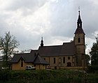
Saints Peter and Paul church

Grave of Polish soldiers fallen during the German invasion of Poland

Grave of Polish priests and organist, murdered by the Germans during World War II

Aerial view


References[]
- ^ "Central Statistical Office (GUS) - TERYT (National Register of Territorial Land Apportionment Journal)" (in Polish). 2008-06-01.
- ^ Maria Wardzyńska, Był rok 1939. Operacja niemieckiej policji bezpieczeństwa w Polsce. Intelligenzaktion, IPN, Warszawa, 2009, p. 98 (in Polish)
External links[]
| Seat | ||
|---|---|---|
| Other villages | ||
This Kłobuck County location article is a stub. You can help Wikipedia by . |
- Kłobuck County geography stubs
- Villages in Kłobuck County