Pasłęk
Pasłęk | |
|---|---|
 Medieval town walls and the Mill Gate | |
 Flag  Coat of arms | |
 Pasłęk | |
| Coordinates: 54°3′N 19°40′E / 54.050°N 19.667°ECoordinates: 54°3′N 19°40′E / 54.050°N 19.667°E | |
| Country | |
| Voivodeship | |
| County | Elbląg |
| Gmina | Pasłęk |
| Established | 13th century |
| Town rights | 1297 |
| Government | |
| • Mayor | Wiesław Śniecikowski[1] |
| Area | |
| • Total | 11.39 km2 (4.40 sq mi) |
| Population (2017[1]) | |
| • Total | 12,298 |
| • Density | 1,100/km2 (2,800/sq mi) |
| Time zone | UTC+1 (CET) |
| • Summer (DST) | UTC+2 (CEST) |
| Postal code | 14-400 |
| Area code(s) | +48 55 |
| Vehicle registration | NEB |
| Climate | Dfb |
| Website | http://www.paslek.pl |


Pasłęk (pronounced [ˈpaswɛŋk]; German: ![]() Preußisch Holland (help·info), Old Prussian: Pāistlauks), formerly known in Polish as Holąd Pruski, is a historic town in northern Poland, within Elbląg County in the Warmian-Masurian Voivodeship. In 2017, the town had 12,298 registered inhabitants.
Preußisch Holland (help·info), Old Prussian: Pāistlauks), formerly known in Polish as Holąd Pruski, is a historic town in northern Poland, within Elbląg County in the Warmian-Masurian Voivodeship. In 2017, the town had 12,298 registered inhabitants.
History[]

The oldest record of the name of the Pasłęk territory appears as Pozolucensis provincia in a petition of Polish Dominicans to Pope Gregory IX from 1231.[2] Later in the 13th and 14th century the settlement was mentioned in documents as Pazluch, Pazlok, Paslok.[2] In 1393 it was mentioned by a frater Heinricus de Castro alias Pasloci. Pasłęk is one of two historic Polish names of the town and it derives from the Old Prussian place name Passis Lukis.
The second name is Holąd Pruski. The town in the place of the old settlement was founded by settlers imported from Holland by the Teutonic Order in the late 13th century — hence the name Hollant or Holland,[2] later changed to Preußisch Holland, by adding the adjective Preußisch meaning "Prussian". It is the oldest former Dutch settlement in present-day Poland. It is located in the Prussian historical region of Pogesania.
After the Polish victory at the Battle of Grunwald in 1410, the castle was plundered by the retreating Teutonic Knights.[2] Then it was taken over by Poles without a fight.[2]
In 1440 the town joined the Prussian Confederation[3] and with the confederation in 1454 it joined Poland.[4] During the Thirteen Years’ War (1454–1466) it was briefly captured by the Teutonic Knights, but in 1456 it returned to Poland.[4] The town was successfully defended against the Teutonic Knights in 1463 and 1466.[4] After the peace treaty signed in Toruń in 1466, the town remained under Polish suzerainty as a fief, as part of the Teutonic Order's state. During the last Polish–Teutonic War, which broke out after the newly chosen Grand Master of the Teutonic Order refused to submit to the Crown of Poland, the town was captured and held by the Poles from 1520 until the dissolution of the Teutonic state in 1525.[3] Afterwards it remained part of the secular Duchy of Prussia, a Polish fief until 1657. In 1526 a Lutheran parish was founded.[3] In 1534 a town school was established.[2]
In 1627 the town was captured by the Swedes and the next year it was captured by the Poles.[4] In 1635, peace negotiations between Poland and Sweden took place in Pr. Holland.[2][4] In 1655 the town was captured again by the Swedes.[2] In 1659 it was besieged by Sweden again, but this time without success.[2][4] It was the location of "The Great Sleigh Drive", a military operation in 1678. In 1688 a horse post service connecting Marienburg (Malbork) with Königsberg was led through the town.[3] Between 1758 and 1762 it was under Russian occupation.[2][5] In 1807 it was captured by Napoleonic troops.[5] French troops were stationed in the town in 1807 and 1812.[3] In 1818 Preußisch Holland became the seat of the district or county (landkreis) of the same name.[6] In 1831 the town suffered a flood.[5]
Part of the Kingdom of Prussia since 1701, it became part of the German Empire in 1871. Following the defeat of Germany in the First World War and the Versailles Treaty the town remained the seat of Landkreis Preußisch Holland within Weimar Germany's exclave East Prussia. With the arrival of the Red Army on January 23, 1945, and the end of the war, Preußisch Holland became part of the People's Republic of Poland. It was handed over to Polish administration on June 1, 1945 and renamed to the historic name Pasłęk on 7 May 1946.[7] The remaining ethnic Germans were expelled in several transports within the following year, e.g. 149 people on 4 September and 89 on 4 October 1947. A transport of 80 children from an orphanage, many of them survivors of the Grünhagen railway accident or wartime evacuees, left in May 1947. As of 1950, 373 pre-war inhabitants lived in the area, a number reduced to 20 in 1958.[8]
In 1969, the "Pasłęczanka" Housing Cooperative was founded, which built the "Osiedle Ogrodowa" district.[3] In 1975 an economic and technical school was opened.[3]
Sights[]
Among the historic heritage of Pasłęk are:
- medieval town walls with the Stone Gate (Brama Kamienna) and Mill Gate (Brama Młyńska)
- Gothic town hall (Ratusz)
- Gothic St. Bartholomew Church
- Pasłęk Castle
- Renaissance Saint George church
- Water tower
- Gothic Revival Church of the Nativity of Mary
- Old townhouses
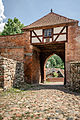
Mill Gate (Brama Młyńska)

Gothic town hall (Ratusz)

St. Bartholomew Church

Pasłęk Castle

Water tower

Church of the Nativity of Mary


Transport[]
The National road 7 of Poland runs through the town, connecting it with Gdańsk, Warsaw, Kraków and the border with Slovakia at Chyżne.
Also, a railway station is located in Pasłęk.
Twin towns[]
Pasłęk is twinned with:
Notable residents[]
- Joachim Friedrich Henckel (1712–1779), Prussian surgeon
- Victor Valois (1841-1924), German naval officer, Vice Admiral
- Hugo Erdmann (1862–1910), German chemist
- Max Liedtke (1894–1955), German journalist and Righteous Among the Nations
- Lotte Laserstein (1898–1993), German-Swedish painter and portraitist
- Dietmar Damerau (1935–2011), German artist
- Hans Grodotzki (born 1936), East German long-distance runner
- Bolesław Szymański (born 1950), Polish computer scientist
- Katarzyna Ankudowicz (born 1981), Polish actress
References[]
- ^ Jump up to: a b "Pasłęk (warmińsko-mazurskie)". Polska w liczbach (in Polish). Retrieved 27 November 2019.
- ^ Jump up to: a b c d e f g h i j "Pasłęk - Historia Wysoczyzny Elbląskiej". Retrieved June 8, 2019.
- ^ Jump up to: a b c d e f g h i "Historia miasta". Oficjalny serwis miasta Pasłęk (in Polish). Retrieved 27 November 2019.
- ^ Jump up to: a b c d e f Słownik geograficzny Królestwa Polskiego i innych krajów słowiańskich, Tom III, Warsaw, 1882, p. 97 (in Polish)
- ^ Jump up to: a b c Słownik geograficzny Królestwa Polskiego i innych krajów słowiańskich, Tom III, Warsaw, 1882, p. 98 (in Polish)
- ^ "Aus der Geschichte der jüdischen Gemeinden im deutschen Sprachraum" (in German).
- ^ "Zarządzenie Ministrów: Administracji Publicznej i Ziem Odzyskanych z dnia 7 maja 1946" (pdf) (in Polish).
- ^ Wisniewska, Joanna Ewa (2012). Preussisch Holland: Die Vertreibung/Aussiedlung der deutschen Bevölkerung 1945-1950 (in German). Akademikerverlag. pp. 135 ff., 140, 159. ISBN 978-3639431391.
External links[]
| Wikimedia Commons has media related to Pasłęk. |

| show Authority control |
|---|
- Cities and towns in Warmian-Masurian Voivodeship
- Elbląg County