Patate Canton
Patate Canton | |
|---|---|
Canton | |
 Tungurahua Province in Ecuador | |
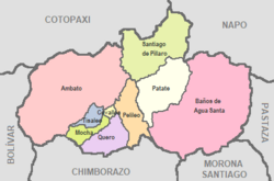 Cantons of Tungurahua Province | |
| Coordinates: 01°19′S 78°31′W / 1.317°S 78.517°WCoordinates: 01°19′S 78°31′W / 1.317°S 78.517°W | |
| Country | |
| Province | Tungurahua Province |
| Capital | Patate |
| Government | |
| • Mayor | Medardo Chiliquinga |
| Area | |
| • Total | 315 km2 (122 sq mi) |
| Population (2010) | |
| • Total | 13,497 |
| • Density | 42.85/km2 (111.0/sq mi) |
| Time zone | UTC-5 (ECT) |
| Area code(s) | 593 |
| Website | Patate Autonomous Decentralized Government |

Patate Canton is a canton of Ecuador, located in the Tungurahua Province. Its capital is the town of Patate. Its population at the 2010 census was 13,497.[1]
The still active Tungurahua volcano is situated within the canton.
Patate (town and canton) was declared a Pueblo Mágico (magical town) by Ecuador's Ministry of Tourism (MINTUR) in 2019. It was the first community in the country to be awarded this distinction.[2]
References[]
- ^ "Archived copy". Archived from the original on 2014-02-26. Retrieved 2014-02-26.
{{cite web}}: CS1 maint: archived copy as title (link) at statoids.com - ^ "Patate es oficialmente un 'Pueblo Mágico' del país". El Comercio. Retrieved 2021-04-02.
External links[]
| Azuay |
|
|---|---|
| Bolívar |
|
| Cañar | |
| Carchi | |
| Chimborazo | |
| Cotopaxi | |
| El Oro | |
| Esmeraldas |
|
| Galápagos |
|
| Guayas |
|
| Imbabura |
|
| Loja | |
| Los Ríos |
|
| Manabí |
|
| Morona-Santiago |
|
| Napo |
|
| Orellana | |
| Pastaza |
|
| Pichincha | |
| Santa Elena |
|
| Santo Domingo de los Tsáchilas |
|
| Sucumbíos |
|
| Tungurahua | |
| Zamora-Chinchipe |
|
This Ecuador location article is a stub. You can help Wikipedia by . |
Categories:
- Ecuador geography stubs
- Cantons of Tungurahua Province