Pataua
Pataua | |
|---|---|
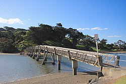 Footbridge across the Pataua River joining North Pataua and South Pataua | |
 Pataua | |
| Coordinates: 35°43′08″S 174°31′27″E / 35.718847°S 174.524033°ECoordinates: 35°43′08″S 174°31′27″E / 35.718847°S 174.524033°E | |
| Country | New Zealand |
| Region | Northland Region |
| District | Whangarei District |
| Population | |
| • Total | 1,584 |

Pataua (Māori: Pātaua) is a settlement in Northland Region, New Zealand. It lies at the mouth of the Pataua River on the Pacific Ocean. Pataua North and Pataua South are separated by a footbridge over the estuary.[1]
A community hall is run by the Pataua Outdoor Education and Recreation Trust that is now used mostly for school camps by Primary and Secondary schools from the Whangarei District. It was once a one-room school but the school closed in the 1980s due to low numbers.[2]
In recent years a number of the surrounding beef farms have moved towards permaculture, sustainability, and ecotourism.[3][4] It is also a popular surfing destination.[5]
The local Pātaua Marae is a meeting ground for the Ngātiwai hapū of Ngāti Kororā.[6][7]
Demographics[]
| Year | Pop. | ±% p.a. |
|---|---|---|
| 2006 | 1,131 | — |
| 2013 | 1,278 | +1.76% |
| 2018 | 1,584 | +4.39% |
| Source: [8] | ||
The statistical area of Pataua, which at 129 square kilometres is much larger than the settlement, had a population of 1,584 at the 2018 New Zealand census, an increase of 306 people (23.9%) since the 2013 census, and an increase of 453 people (40.1%) since the 2006 census. There were 540 households. There were 804 males and 780 females, giving a sex ratio of 1.03 males per female. Of the total population, 354 people (22.3%) were aged up to 15 years, 213 (13.4%) were 15 to 29, 810 (51.1%) were 30 to 64, and 204 (12.9%) were 65 or older. Figures may not add up to the total due to rounding.
Ethnicities were 90.5% European/Pākehā, 16.1% Māori, 1.7% Pacific peoples, 1.1% Asian, and 2.8% other ethnicities. People may identify with more than one ethnicity.
The percentage of people born overseas was 18.8, compared with 27.1% nationally.
Although some people objected to giving their religion, 64.4% had no religion, 23.7% were Christian, and 3.2% had other religions.
Of those at least 15 years old, 246 (20.0%) people had a bachelor or higher degree, and 183 (14.9%) people had no formal qualifications. The median income was $32,800. The employment status of those at least 15 was that 639 (52.0%) people were employed full-time, 225 (18.3%) were part-time, and 30 (2.4%) were unemployed.[8]
References[]
- ^ Hariss, Gavin. "Pataua, Northland". topomap.co.nz. NZ Topo Map.
- ^ "Pataua Outdoor". patauaoutdoor.org.nz. Pataua Outdoor.
- ^ Davis, Lindy (17 March 2018). "Tahi: Place of plenty". New Zealand Media and Entertainment. New Zealand Herald.
- ^ "Significant Ecological Marine Area Assessment Sheet" (PDF). nrc.govt.nz. Northland Regional Council.
- ^ "Surf Pad". surfpad.co.nz. Surf Pad.
- ^ "Te Kāhui Māngai directory". tkm.govt.nz. Te Puni Kōkiri.
- ^ "Māori Maps". maorimaps.com. Te Potiki National Trust.
- ^ a b "Statistical area 1 dataset for 2018 Census". Statistics New Zealand. March 2020. Pataua (108000). 2018 Census place summary: Pataua
- Whangarei District
- Populated places in the Northland Region