Waipu, New Zealand
Waipu | |
|---|---|
 | |
 Waipu | |
| Coordinates: 35°59′5″S 174°26′50″E / 35.98472°S 174.44722°E | |
| Country | New Zealand |
| Region | Northland Region |
| District | Whangarei District |
| Population (2018) | |
| • Total | 2,715 |


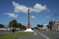
Waipu (Māori: Waipū) is a small town established in the rohe of the Patuharakeke hapū, in Te Tai Tokerauthe Northland Region of New Zealand. The town is celebrated for its settlement by Nova Scotians and other settlers of Scottish heritage. A highlight of the town's calendar is the annual Highland Games held at New Year. Near the town are the Waipu Caves, which contain a significant population of glow worms.
History[]
The tangata whenua of Waipū, Patuharakeke are the descendants of Te Toru (also known as Urekuri), Te Taotahi and Te Pirihi Whakaariki. It is through the descendants of Te Toru that Patuharakeke are closely related to iwi including Ngapuhi, Ngati Wai, Ngati Whatua and Te Uri o Hau. Through a series of Crown breaches, outlined in the Patuharakeke Statement of Claim provided in support of the Waitangi Tribunal Cases 745 and 1348, Patuharakeke were alienated from their lands which were confiscated, cleared and on-sold by the crown for colonial settlement. Waipu was the centre of a significant Presbyterian settlement led by Rev. Norman McLeod, a Presbyterian minister who led his people from the Highlands of Scotland to New Zealand via Pictou and St. Ann's in Nova Scotia and Australia. Five shiploads containing over 800 settlers arrived at Waipu in the 1850s.[1]
In 1914, a railway branch line from the North Auckland Line was surveyed to Waipu to serve agricultural activity in the area. Construction of the Waipu Branch line was delayed due to World War I, but by 1920, 25 men were employed in the construction of formation. However, by 1924, private motor vehicles were becoming more common and railway lines to sparsely-populated rural areas accordingly became less necessary. Due to the lack of significant industrial activity in the Waipu area, the branch line was no longer seen as economic and construction was cancelled before any rail tracks were laid.[2] A new railway line, the Marsden Point Branch, is currently proposed for construction and will follow a route similar to that of the abortive Waipu line.
Demographics[]
| Year | Pop. | ±% p.a. |
|---|---|---|
| 2006 | 1,818 | — |
| 2013 | 2,082 | +1.96% |
| 2018 | 2,715 | +5.45% |
| Source: [3] | ||
The statistical area of Waipu, which at 137 square kilometres is much larger than the town, includes Waipu Cove and Langs Beach, and extends west past State Highway 1. It had a population of 2,715 at the 2018 New Zealand census, an increase of 633 people (30.4%) since the 2013 census, and an increase of 897 people (49.3%) since the 2006 census. There were 1,113 households. There were 1,350 males and 1,368 females, giving a sex ratio of 0.99 males per female. Of the total population, 405 people (14.9%) were aged up to 15 years, 291 (10.7%) were 15 to 29, 1,221 (45.0%) were 30 to 64, and 801 (29.5%) were 65 or older. Figures may not add up to the total due to rounding.
Ethnicities were 92.4% European/Pākehā, 14.5% Māori, 1.9% Pacific peoples, 2.7% Asian, and 1.7% other ethnicities. People may identify with more than one ethnicity.
The percentage of people born overseas was 21.0, compared with 27.1% nationally.
Although some people objected to giving their religion, 54.5% had no religion, 34.6% were Christian, and 3.4% had other religions.
Of those at least 15 years old, 432 (18.7%) people had a bachelor or higher degree, and 450 (19.5%) people had no formal qualifications. The median income was $28,100. The employment status of those at least 15 was that 903 (39.1%) people were employed full-time, 369 (16.0%) were part-time, and 66 (2.9%) were unemployed.[3]
Education[]
Waipu School is a coeducational contributing primary (years 1-6) school with a decile rating of 7 and a roll of 206.[4]
Schools were formed in the Waipu area at Waipu Cove, Bream Tail, Waipu Centre, The Braigh, North River and Waipu Cove. The schools at Bream Tail and Waipu Caves closed before 1930. The remaining schools, and one at Mata north of Ruakaka, were consolidated into Waipu District High School in 1940, which provided both primary and secondary education on a single site on St Mary's Road. Ruakaka School was originally intended to be included in the consolidation, but residents of Ruakaka resisted. In 1956, the secondary department moved to a new site in Argyle Street, although some secondary classes remained at the original site. By the late 1960s, Waipu was the largest District High School in the country and had inadequate facilities. The school was split at the beginning of 1972 to form the new Bream Bay College and Waipu Primary, with the high school shifting to new premises at Ruakaka in 1974. The primary school moved to the Argyle Street site.[5]
Notable people[]
Members of the metal band Alien Weaponry come from Waipu.
References[]
- ^ "Auckland's immigrants: 1853 to 1870". Te Ara: The Encyclopedia of New Zealand.
- ^ Churchman & Hurst 2001, p. 100.
- ^ Jump up to: a b "Statistical area 1 dataset for 2018 Census". Statistics New Zealand. March 2020. Waipu (109000). 2018 Census place summary: Waipu
- ^ "Te Kete Ipurangi - Waipu School". Ministry of Education.
- ^ Gordon, Charles MacNeill (Mac) (2002). "Education Always a Priority". Pride of the Lion: Waipu - the People and the Place. pp. 191–227. ISBN 0-473-08890-8.
Further reading[]
- Churchman, Geoffrey B; Hurst, Tony (2001) [1990, 1991]. The Railways of New Zealand: A Journey through History (Second ed.). Transpress New Zealand. ISBN 0-908876-20-3.
External links[]
- Waipu Online
- Waipu Caledonian Society
- Waipu Museum
- Waipu Presbyterian Church
- Waipu Boat and Fishing Club
Coordinates: 35°59′S 174°27′E / 35.983°S 174.450°E
| hide Authority control | |
|---|---|
| General |
|
| National libraries | |
| Other |
|
- Whangarei District
- Populated places in the Northland Region