Pathanamthitta district
This article possibly contains original research. (June 2017) |
Pathanamthitta district | |
|---|---|
District | |
  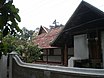    Clockwise from top: Thiruvalla town, Aranmula Kottaram, Aranmula kannadi, 33 Kilovolt Substation at Ranni-Perunad, Gavi, and Elephant Training Center, Konni. | |
 Pathanamthitta district Location in Kerala | |
| Coordinates: 9°16′50″N 76°52′11″E / 9.28068°N 76.86967°ECoordinates: 9°16′50″N 76°52′11″E / 9.28068°N 76.86967°E | |
| Country | |
| State | Kerala |
| Founded by | K. K. Nair[1] |
| Headquarters | Pathanamthitta |
| Area | |
| • Total | 2,642 km2 (1,020 sq mi) |
| Population (2011) | |
| • Total | 1,197,412 |
| • Density | 452/km2 (1,170/sq mi) |
| Languages | |
| • Official | Malayalam |
| Time zone | UTC+5:30 (IST) |
| ISO 3166 code | IN-KL |
| Vehicle registration | KL-03 (Pathanamthitta RTO) KL-26 (Adoor SUB RTO) KL-27 (Thiruvalla SUB RTO) KL-28 (Mallapally SUB RTO) KL-62 (Ranny SUB RTO) KL-83 (KonniSUB RTO). |
| HDI (2005) | |
| Website | pathanamthitta |
Pathanamthitta District is a district in the southern part of Kerala, India. The district headquarters is in the town of Pathanamthitta. There are four municipalities in Pathanamthitta: Tiruvalla, Adoor, Pathanamthitta and Pandalam.
According to the 2011 Census of India, the population was 1,197,412, making it the third least populous district in Kerala (out of 14), after Wayanad and Idukki.[3] Pathanamthitta has been declared the first polio-free district in India.[4] The district is 10.03% urbanised.[5] Pathanamthitta is one of the richest districts in India with just 1.17% poverty as of 2013, which places the district among top 5 districts in India with least poverty.[6]
Etymology
The district's name is a combination of two Malayalam words, pathanam and thitta, which together mean 'array of houses on the river side'.[7] The district capital is located on the banks of the river Achankovil.
History
It is presumed that the regions that form the district were formerly under the rule of Pandalam, which had connections with the Pandya kingdom.[8] When Pandalam was added to the princely state of Travancore in 1820, the region came under Travancore administration. The Nedumpuram Palace near Thiruvalla belongs to Valluvanad Royal family, who were originally the rulers of Angadippuram in present-day Malappuram district.
The district was formed on 1 November 1982 as a reward to K. K. Nair, who was the then Pathanamthitta MLA, by K. Karunakaran. The formation was done by incorporating various portions of the erstwhile Kollam, Alappuzha and Idukki districts. While the taluks Pathanamthitta, Adoor, were taken from Kollam district, Ranni, Konni and Kozhencherry from Idukki district, Pandalam and Thiruvalla were taken from Alappuzha district.[7]
Cultural revival
Pathanamthitta being also a land of culture and learning could bring forth the literary talents of two centuries together in single volume named Desathuti: Pathanamthitta Kavithakal. Unnikrishnan Poozhikkad collected 184 poems of different poets of Pathanamthitta starting from 18th century.[9][page needed].
Geography
Pathanamthitta is a landlocked district, located at 9°16′N 76°47′E / 9.27°N 76.78°E, spanning over an area of 2,637 square kilometres (1,018.15 sq mi).[10] The district is bordered by the districts Kottayam and Idukki districts in the north, Alappuzha district in the west, Kollam district in the south. To the east it borders the Tenkasi district of the Tamil Nadu state. Devar Mala is the highest point in Pathnamthitta District.[11]
The district can be divided into three natural geographical regions: the highland, the midland and the lowland. The highland stretches through the Western Ghats, where the hills are tall and covered with thick forests. Western Ghats maintains an average altitude of around 800 m. It descends to the smaller hills of midland in the centre and finally to the lowland. The lowland with its abundance of coconut trees, lies along the eastern borders of Alappuzha district.[12] (western part of Tiruvalla Taluk)
Forest
Pathanamthitta district has a reserve forest area of 1,385.27 square kilometres (534.86 sq mi).[13] This is approximately 50% of the total district area. The forest area can broadly be classified as evergreen, semi-evergreen and moist deciduous. The forest is the main source of raw materials for wood based industrial units. Timber is the most important produce.
Rivers
Three important rivers flow through the district. These rivers originate from various mountains of the Western Ghats mountain range. The Pamba (176 km or 109 mi), which is the third longest river in Kerala, has its origin in Pulachimala. The Achankovil river (128 km or 80 mi) originates from Pasukida Mettu, and Manimala river (90 km or 56 mi) originates from the Thattamalai hills. A small portion of Kallada river also falls in the southern border of the district. Pamba, Achankovil and Manimala rivers together drain more than 70% of the total area of Pathanamthitta.[14][15]
Administration
The district headquarters is at Pathanamthitta town. The district administration is headed by the District Collector. He is assisted by five Deputy Collectors holding charges of general matters, revenue recovery, land acquisition, land reforms and election. Under the three tier system of panchayat in rural areas, Pathanamthitta has one district panchayat, 9 block panchayat and 57 grama panchayats. Under the single tier system in urban areas, there are 4 municipalities the district. In addition, there is a census town (Kozhencherry).
As per the Delimitation of Parliamentary and Assembly Constituencies Order, 2008, Pathanamthitta has five Assembly constituencies, down from eight. However, the district was unified into a single Parliamentary constituency, thus contributing a seat to the Lok Sabha. The Pathanamthitta parliamentary constituency is formed by including all the five Assembly constituencies of the district along with two other Assembly constituencies in the neighboring Kottayam district.[16][17] Congress, Kerala Congress, and the CPM/CPI are the main political parties.
Taluks:6
- Adoor
- Konni
- Kozhencherry
- Ranni
- Thiruvalla
- Mallapally
Municipalities: 4
- Adoor
- Pathanamthitta
- Thiruvalla
- Pandalam
Demographics
According to the 2011 census Pathanamthitta district has a population of 1,197,412,[3] roughly equal to the nation of Timor-Leste[18] or the US state of Rhode Island.[19] This gives it a ranking of 399th in India (out of a total of 640).[3] The district has a population density of 453 inhabitants per square kilometre (1,170/sq mi).[3] Its population growth rate over the decade 2001–2011 was −3.12%.[3] Pathanamthitta has a sex ratio of 1129 females for every 1000 males,[3] and a literacy rate of 96.93%.[3] Pathanamthitta District is one of the few districts to have negative growth in population.
According to the Census of India 2001, the district had a population of 1,234,016 with a density of 467 persons per square kilometre.[20] This is the lowest density in the State after Idukki and Wayanad.[21] Schedule tribes and castes comprise 13% of the total population. The female to male ratio is 1094:1000, which is the highest among the districts in the State.[22] Pathanamthitta's literacy rate is 95%.
| Year | Pop. | ±% p.a. |
|---|---|---|
| 1901 | 276,251 | — |
| 1911 | 317,072 | +1.39% |
| 1921 | 375,935 | +1.72% |
| 1931 | 478,345 | +2.44% |
| 1941 | 576,436 | +1.88% |
| 1951 | 719,272 | +2.24% |
| 1961 | 888,272 | +2.13% |
| 1971 | 1,028,208 | +1.47% |
| 1981 | 1,125,345 | +0.91% |
| 1991 | 1,188,332 | +0.55% |
| 2001 | 1,234,016 | +0.38% |
| 2011 | 1,197,412 | −0.30% |
| source:[23] | ||
Religion
Hinduism (57%) is followed by the majority of population of Pathanamthitta. Christians (Malankara Orthodox, Marthoma Church and Protestant) are majority (38%) form significant minority.[24]
Transport
Trivandrum International Airport (TRV) at Thiruvananthapuram (119 km or 74 mi) and Cochin International Airport at Kochi (137 km or 85 mi) are the nearest airports. Aranmula International Airport was planned at Aranmula, 18 km from Pathanamthitta town but was cancelled in 2018. The Pathanamthitta Sabarimala airport is being planned in Konni.
Education
Religious conventions
- The Cherukolpuzha Convention, in Pathanamthitta is an important religious convention of the Hindus. It is held at Cherukole on the sand banks of Pamba River, usually in February every year. It is organized by the Ayroor-Cherukolpuzha Hindumatha Maha Mandalam at Vidyadhiraja Nagar at Ayroor village.[25]
- The Maramon Convention, one of the largest Christian convention in Asia, is held at Maramon, Pathanamthitta, Kerala, India annually during the month of February on the vast sand-bed of the Pampa River next to the Kozhencherry Bridge. It is organised by Mar Thoma Evangelistic Association, the missionary wing of the Mar Thoma Church.
- The Church of God (Full Gospel) in India, Kerala State, holds its annual convention in Tiruvalla town center. This is usually held in the month of January and is a large gathering of Pentecostal Christians.
Places of Worship


- The Sabarimala Sree Ayyappa Temple, a world-famous pilgrim centre, situated in the Sabarimala hills in the Pathanamthitta district. It is known as the 'Pilgrim Capital of Kerala'.
- Pampa Sree Ganapathy Temple
- Nilackal Mahadeva Temple
- Mannady Sree Bhagavathy Temple
- Perinad Dharma Sastha Temple
- Kaviyoor Mahadeva Temple
- Kadammanitta Bhagavathy Temple
- Pandalam valiya Koickal Dharma Sastha Temple
- Thiruvalla Sree Vallabha Temple
- Adoor Partha Sarathy Temple
- Omalloor Devi Temple
- Manjinikkara Dayara
- St Stephens Jackobite Syrian Orthodox Catheedral Manjinikkara.
- Aranmula Parthasarathy Temple is one of the Divya Desams, the 108 temples of Vishnu revered by 12 poet saints, or Alwars.
- Anikkattilammakshethram, Shivaparvathy temple
- Malayalappuzha Devi Temple in Malayalappuzha
- in Malamekkara, Adoor.Atham Thirunal Maho ulsavam & Apindi Vilakku ulsavam in Atham festival Of Mulluthara Devi Temple.
- India Pentecostal Church of God, Hebronpuram, Kumbanad.
- St. Peter and St. Paul's Church, Parumala
- St. George Orthodox Church, Mylapra, also known as Mylapra Valiyapalli
- St Mary's Orthodox Church, Kallooppara
Tourism

With a number of fairs and festivals, Pathanamthitta district is known as the "headquarters of pilgrimage tourism."[26] The district receives an estimated 3 to 4 million pilgrims during the festival season of Sabarimala temple.[27] The temple is dedicated to the Hindu deity, Ayyappan. The district is a host to Asia's biggest and the world's second largest Christian convention, the Maramon Convention[28]

It is an eight-day Christian gathering in the month of February, conducted by the Malankara Marthoma Syrian Church and dedicated to gospel preaching by renowned Christian missionaries from all over the world, and held at Maramon on the sand-bed of Pamba River. The three-day Christian gathering is held at Makkamkunnu, Pathanamthitta known as by Malankara Orthodox Church. The Cherukolpuzha Hindu convention, Kadammanitta devi temple, the 10th century Kaviyoor mahadeva temple, Parthasarathi temple at Aranmula and anikkattilammakshethram[29] are some of the Hindu religious places of interest.

The most important and famous Christian center is Parumala St Peters, St Paul's and St Gregorios Orthodox Church (http://parumalachurch.org) famous for the tomb of Saint Gregorios (Parumala Thirumeni). Millions of Pilgrims visit this church annually.
St. George Orthodox Church, Chandanapally or Chandanapally Valiyapalli is one of the biggest churches in South India, located at a village named Chandanapally, Pathanamthitta District.

St. George Orthodox Church, Mylapra or Mylapra Valiyapalli or Chakkittayil palli (ചക്കിട്ടേൽ പള്ളി) is one of the famous Georgian pilgrim centre which is very close to Pathanamthitta District headquarters.

Some of the other Christian places of interest are St. Mary's Orthodox church at Niranam, St. Thomas Ecumenical Church at Nilackal, the Mor Ignatius Dayro Manjinikkara of the Syriac Orthodox Church of India, St Stephen's Jacobite Church, Parumala Seminary and St. Mary's Orthodox Cathedral, Thumpamon also known as Thumpamon Valiya Pally, headquarters of Thumapmon Diocese of Malankara Orthodox Church. The churches at Niranam and Nilackal (Chayal) are believed to be among the seven churches founded by St. Thomas the Apostle.[30][31] The Muslim colourful Chandanakkudam festival of the Jama — Al Mosque at Pathanamthitta town attracts many visitors. Although these places are religious in nature, they attract people from all faiths.
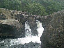
The district is known for its reserve forest and wild life. Perunthenaruvi water falls, Kakki reservoir surrounded by forest and wild animals, dam sites at Moozhyar and Maniyar, elephant training centre at Konni, Charalkunnu hill station are ideal locations for nature enthusiasts. Trekking to the Sabari Hills during January to March is also organized by Pathanamthitta District Tourism Promotion Council (DTPC).
Pathanamthitta district has places known for its historical importance. Among them are, ancient Valiyakoickal Temple and Palace at Pandalam, monument of Velu Thampi Dalawa at Mannadi and the Muloor Smarakom (Muloor memorial). Pandalam was the capital of the ancient Travancore kingdom.
The district has other tourist attractions. Aranmula is a major attraction for its famous metal mirrors and snake boat race. The school of traditional arts attracts foreign visitors. Founded by French artist Louba Schild, the school teaches kathakali, classical dance, classical music as well as kalarippayattu. The palace at Aranmula Aranmula kottaram has a history of 200 years.[32]
Flora and fauna
The forests of the district have excellent wild life habitats. A variety of animals and birds can be found. Tigers, elephants, gaur, deer, monkeys and other wild animals are found in the forest. Giant squirrel, lion-tailed macaques, barking deer and bear can also be spotted in the reserve. Malabar grey hornbill and great Indian hornbill are found. Wide variety of other birds such as sunbirds, woodpeckers and kingfishers can also be seen.
The existence of the wildlife habitat is under threat from various areas. Pollution from fertilizer and industries and illegal sand mining are the major threats. Issues connected to Sabarimala pilgrimage such as clearing of forest land and large amount of waste discharged also threatens the habitat.[14][33]
Sports
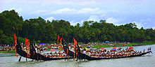
The Aranmula Boat Race is part of a festival celebrated during the month of September. Though the snake boat race is also performed at nearby places, the race held at Aranmula is unique because of the boats' shape and design. Maramadimatsaram (Ox Race) is another such seasonal sport. This is held as part of the largest annual cattle fair of Central Travancore region. The race is held in three categories.[34]
See also
Further reading
- U. Sivaraman Nair (1952), 1951 Census Handbook- Quilon District (PDF), Trivandrum: Travancore-Cochin Government Press
- M. K. Devassy (1965), 1961 Census Handbook- Quilon District (PDF), Directorate of Census Operations, Kerala and The Union Territory of Laccadive, Minicoy, and Amindivi Islands
- Sheela Thomas (2003), 2001 Census Handbook- Pathanamthitta District (Part-A&B) (PDF), Directorate of Census Operations, Kerala
- Government of India (2014–15), District Census Handbook - Pathanamthitta (Part-A) 2011 (PDF), Directorate of Census Operations, Kerala
- Government of India (2014–15), District Census Handbook - Pathanamthitta (Part-B) 2011 (PDF), Directorate of Census Operations, Kerala
References
- ^ "Pathanamthitta Collectorate opens its walls of art for remembering K.K. Nair the Father of Pathanamthitta District". The Hindu. Retrieved 29 April 2017.
- ^ "Kerala | UNDP in India". UNDP.
- ^ Jump up to: a b c d e f g "District Census 2011". Census2011.co.in. 2011. Retrieved 30 September 2011.
- ^ "District profile-Pathanamthitta". Department of Industries and Commerce, Kerala. Archived from the original on 7 April 2010. Retrieved 27 August 2009.
- ^ "Pathanamthitta". Census of India. Archived from the original on 11 January 2010. Retrieved 27 August 2009.
- ^ http://www.livemint.com/Politics/FJwyzCLIJU1DrOR00aFmDK/Spatial-poverty-in-kerala.html
- ^ Jump up to: a b "History". Government of India. Archived from the original on 29 July 2009. Retrieved 27 August 2009.
- ^ "History — Pathanamthitta". Government of Kerala. Retrieved 27 August 2009.[permanent dead link]
- ^ Unnikrishnan Poozhikkad, ″Desathuti: Pathanamthitta Kavithakal″, Lens Books, Adoor, 2012
- ^ "District level database of Pathanamthitta" (PDF). Government of Kerala. 2006. Archived from the original (PDF) on 22 November 2008. Retrieved 25 August 2009.
- ^ "Pathanamthitta information". Kerala tourism. Retrieved 25 August 2009.
- ^ "Pathanamthitta- Physiograpy". Government of India. Archived from the original on 29 July 2009. Retrieved 25 August 2009.
- ^ "Census of India". Government of India. Archived from the original on 14 May 2007. Retrieved 24 August 2009.
- ^ Jump up to: a b "Pampa pollution". Pampa Parirakshana Samithy, N.G.O. Retrieved 27 August 2009.
- ^ "General features — Kerala". Government of Kerala. Archived from the original on 2 November 2006. Retrieved 27 August 2009.
- ^ "Parliamentary Constituencies of Kerala - 2008". Government of Kerala. Archived from the original on 3 September 2009. Retrieved 27 August 2009.
- ^ Radhakrishnan KuttoorKuttoor (31 January 2008). "Due recognition for the youngest district". The Hindu. Retrieved 27 August 2009.[permanent dead link]
- ^ US Directorate of Intelligence. "Country Comparison:Population". Retrieved 1 October 2011.
Timor-Leste 1,177,834 July 2011 est.
- ^ "2010 Resident Population Data". U. S. Census Bureau. Archived from the original on 19 October 2013. Retrieved 30 September 2011.
Rhode Island 1,052,567
- ^ "Data sheet — Pathanamthitta" (PDF). Census of India. Retrieved 27 August 2009.
- ^ "District profile — pathanamthitta" (PDF). Government of Kerala. Archived from the original (PDF) on 25 June 2003. Retrieved 27 August 2009.
- ^ "Demography — Kerala". Government of India. Retrieved 27 August 2009.
- ^ Decadal Variation In Population Since 1901
- ^ https://pathanamthitta.nic.in/demography/
- ^ Cherukolpuzha, Kerala Department of Tourism
- ^ "Places of Interest". Official website — Pathanamthitta. Archived from the original on 27 September 2009. Retrieved 29 August 2009.
- ^ "Sabarimala Sri Dharmasastha Temple". Official website — Pathanamthitta. Archived from the original on 18 August 2009. Retrieved 29 August 2009.
- ^ "Maramon". Department of tourism, Kerala. Archived from the original on 3 January 2011. Retrieved 10 July 2010.
- ^ "Anikattilamma Temple Mallappally :: Siva Parvathy Temple ::anicadu::pathanamthitta". anikkattilamma.com. Retrieved 3 January 2017.
- ^ "St Thomas the Apostle of India". St.Thomas Syro Malabar Mission of San Antonio. Archived from the original on 13 September 2010. Retrieved 15 September 2009.
- ^ "Syro Malabar Church History". St. Thomas Syro-Malabar Church of the Catholic Parish. Archived from the original on 4 June 2008. Retrieved 15 September 2009.
- ^ "Aranmula". Ministry of Tourism, Government of India. Archived from the original on 31 May 2010. Retrieved 7 October 2010.
- ^ "TDB to get forest land at Nilackal today". The Hindu. 16 June 2005. Archived from the original on 6 November 2012. Retrieved 27 August 2009.
- ^ "Maramadimatsaram". Department of tourism, Kerala. Archived from the original on 1 March 2012. Retrieved 27 August 2009.
External links
| Wikimedia Commons has media related to Pathanamthitta district. |
 Pathanamthitta travel guide from Wikivoyage
- Pathanamthitta district official website
- Pathanamthitta District administration
| show Places adjacent to Pathanamthitta district |
|---|
| show |
|---|
| show Travancore region |
|---|

| show Authority control |
|---|
- Pathanamthitta district
- Districts of Kerala
- 1982 establishments in Kerala