
Areekode
This article needs additional citations for verification. (August 2016) |
Areekode
Areacode | |
|---|---|
Town | |
 | |
| Coordinates: 11°14′16″N 76°03′00″E / 11.237716°N 76.050088°E | |
| Country | |
| State | Kerala |
| District | Malappuram |
| Government | |
| • Type | Block Panchayath |
| • Body | UDF |
| Languages | |
| • Official | Malayalam, English |
| Time zone | UTC+5:30 (IST) |
| PIN | 673639 |
| Telephone code | 0483 |
| Vehicle registration | KL-84 |
| Website | http://www.areekode.com/ |
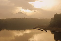
Areekode is a town on the banks of the Chaliyar River in Areekode Grama Panchayat in Malappuram district India. Areekode was part of the Malabar district in British India.
It is a town on the banks of Chaliyar River with an area of 7.25 square miles, Areekode is one of the highly literate areas in the state of Kerala. Situated in the Northern part of Malappuram district, it is encircled by hills and hillocks capped in green. The Areekode region includes Urangatiri, Kizhuparamba, Kavanoor and Areekode panchayats
It is 17 km from Manjeri, 27 km from Malappuram, and 35 km from Calicut town.
Etymology[]

It is believed that the name 'Areekode' was derived from 'Aruvikkode', which in Malayalam means 'riverside'. The town is easily accessible by public road transportation.
History[]
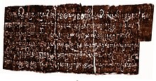
The Kurumathur inscription found near Areekode dates back to 871 CE.[1]
Transportation[]

Areekode connects to other parts of India through Calicut town on the west, Nilambur town on the east, and Manjeri town on the south. It is only 35 km away from Calicut Town. National Highway 66 passes through Calicut and the northern stretch connects to Goa and Mumbai. The southern stretch connects to Cochin and Trivandrum. State Highway 28 starts from Nilambur and connects to Ooty, Mysore, and Bangalore through Highways 12, 29 and 181. The nearest airport is at Karipur CCJ. Karipur Airport (CCJ - Calicut airport) is 30 minutes away from Areekode.
The nearest major railway station is at Calicut CLT.
Important landmarks[]
- 250KV Power Grid
- VKM HYPER MARKET
- Chekkunnu Mala
- Govt. HSS Areacode, Ugrapuram
- WELLTOP (KINARADAPPAN)
- Kadungalloor Bridge
- Kolamkolli Waterfalls Thachamparamba
- Kurumathur Sree Vishnu Temple
- Malabar Special Police Camp
- Methalangadi Juma Masjid
- Nadukkavungl Sree Mahadeva Temple
- Odakkayam Waterfalls
- Pavanna Hanging Bridge
- Puthalam Sunni Masjid
- Police Station
- Sree Bhadrakali Temple, South Puthalam
- Sree Saligrama Temple, Puthalam
- Synthetic Football stadium
- Thachamparamba Mini Stadium
- Thazhathangadi Juma Masjid
- Therattammel ground
- Maithra bridge
- New ALFA Traders rubber dealer
Educational institutions[]
- Vivid PSC Academy
- Vivid ARMY Academy
- Co-operative College
- Eminent Academy
- Govt. HSS Areacode
- Govt. ITI Areacode
- Govt. LPS Thachanna
- Madar Women's Academy
- Majmau Da'wa College
- Majmau English School
- Mices Public School
- PG Academy
- SS HSS Moorkanad
- Sullamussalam Arabic college
- Sullamussalam Oriental HSS Areacode
- Sullamussalam Private ITI
- Sullamussalam Science college
- Sullamussalam Training College
Hospitals[]
- Aster MIMS Areekode
- Alnas Hospital
- Govt. Taluk Hospital
- Melepurakkal Hospital
- Mother Hospital
Banking Services[]
- Areacode Co-operative Bank
- Canara Bank
- Catholic Syrian Bank
- Federal Bank
- Kerala Gramin Bank
- Malappuram District Co-operative Bank
- Manjeri Co-operative Urban Bank
- South Indian Bank
- State Bank of India
Travel Agency[]
- Akbar Travels[2]
- Alhind Tours and Travels[3]
- Enwaytrip Holidays
- Eranad Tourism[4][5]
- Fida Tours and Travels
- Good Hope Enterprises
- Lofty Holidays
- Naila Travels Pvt Ltd[6]
- Pravasi Tours and Travels
Suburbs of Areekode[]
- On Mukkam Road
- Pathanapuram, Kuttooli, Valillapuzha.
- On Othayi Road
- Pathanapuram,
Therattammal, Moorkkanad, Thachanna, Choolattippara
- Kallarattikkal, Thachamparamba
- Maithra , Kuthuparamba
- On Edavanna Route
- South Puthalam, Vaakaloor, Vadasseri, Pottiyil, Pannippara, Palepetta
- On Kondotty Route
- Muthuvalloor, Kadungalloor, Kizhisseri, Chemrakkattoor, Pookkattuchola, Kozhakottur, Puthalam
- On Vazhakkad Route
- Ugrapuram, Poonkudi and Vavoor
- Edasserikkadavu and Kizhuparamba
- Vettupara, Edavannappara
- On Thottumukkam Road
- East Vadakkumuri, Vadakkumuri, Kinaradappan, Vettilappara, Odakkayam
See also[]
References[]
External links[]
![]() Media related to Areekode at Wikimedia Commons
Media related to Areekode at Wikimedia Commons
- Cities and towns in Malappuram district
- Kondotty area
- Populated waterside places in India