Pappinisseri
Pappinisseri | |
|---|---|
Census Town | |
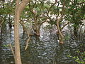
 Mangroves Park | |
 Pappinisseri Location in Kerala, India | |
| Coordinates: 11°57′N 75°21′E / 11.95°N 75.35°ECoordinates: 11°57′N 75°21′E / 11.95°N 75.35°E | |
| Country | |
| State | Kerala |
| District | Kannur |
| Government | |
| • Type | Panchayati raj (India) |
| • Body | Special Grade Panchayat |
| Area | |
| • Total | 15.22 km2 (5.88 sq mi) |
| Elevation | 1 m (3 ft) |
| Population (2011)[1] | |
| • Total | 35,134 |
| • Density | 2,300/km2 (6,000/sq mi) |
| Time zone | UTC+5:30 (IST) |
| PIN | 670561, 670565, 670566 |
| Telephone code | 0497278 |
| ISO 3166 code | IN-KL |
| Vehicle registration | KL-13 |
| Sex ratio | 1068 ♂/♀ |

Pappinisseri is a census town in Kannur district in the Indian state of Kerala.[2] Pappinisseri Panchayat comprises two villages viz Pappinisseri and Aroli. Pappinisseri better known for visha chikitsa kendram (a treatment for snake bite.)
Geography[]
Pappinisseri is located at 11°57′N 75°21′E / 11.95°N 75.35°E.[3] It has an average elevation of 1 metres (3 feet).
Demographics[]
As of 2011 Census, Pappinisseri had a population of 35,134 of which males constitute 15,988 (45.5%) of the population and 19,146 (54.5%) females. Pappinisseri census town spreads over an area of 15.22 km2 (5.88 sq mi) with 7,225 families residing in it. The sex ratio of Pappinisseri was 1,197 higher than state average of 1,084. In Pappinisseri, 11.3% of the population is under 6 years of age. Pappinisseri had an overall literacy of 95.5% higher than state average of 94%. The male literacy stands at 97.6% and female literacy was 93.9%.[4]
Religions[]
As of 2011 census, Pappinisseri census town had total population of 35,134 among which 18,155 (51.7%) are Hindus, 15,774 (44.9%) are Muslims, 1,136 (3.2%) are Christians and 0.2% others.[5]
Culture and Geography[]

Pappinisseri comprises two villages viz Pappinisseri and Aroli. Two major roads viz NH 66 and KSTP Pappinisseri - Pilathara road. Pappinisseri panchayat is situated on the banks of Valapattanam River between Kannur and Payyanur on NH-66. Though the Pappinisseri village provides spaces for the both of these major roads, Aroli is home for only NH-66. KSTP constructed Pappinisseri Pilathara road which act as a bypass towards Payyanur that reduces the distance and travel time between Kannur and Payyanur.[6]
Major portion of Pappinisseri is surrounded by Baliapatam river which stretches from Mankkadav at the East to CRC at the West. Pappinisseri has many small islands and hills. Pampuruthi is a very famous islands in the Baliapatam river.[citation needed] Vadeswaram Hill, popularly known as Kailasam of Kerala, is famous for its scenery.[citation needed] Pappinisseri shares borders with Kalliasseri to the north-east and Valapattanam to the south-west.
Pappinisseri is a rail head (Nearest Major Railway Station is Kannur). Kannur International Airport is the nearest airport.
Pappinisseri is known for:
- Moonnu Pettumma Palli
- Chittothidam Mantramoorthi temple
- Sree Vadeswaram Shiva Temple
- Aaron Church
- Assemblies of God Church, Pappinisseri
- Mankadavu Juma Masjid
- Keecheri Juma Masjid
- Keecheri Paalottu Kavu,
- Visha Chikilsa Kendram
- Tile Works,
- Cotton Factory
- M.V. Raghavan
Moonnu Pettumma Palli[]
Moonnu Pettumma Palli (Mosque in the golden memory of the mother who gave birth to the three), popularly known as "Kattile Palli" (Mosque in the Jungle) is the most popular Mosque of North Malabar. The annual festival known as "Kattile Palli Nercha" is attended by people from all religions. This festival is one of the most important festival where the secularism of North Malabar is transparently visible. This Mosque is at Pappinisseri, around 8 km from Kannur, 14 km from Taliparamba and 24p;km from Payyannur.
Aaron Church, Pappinisseri[]
This church is on NH-17 at Pappinisseri. This Church around 9 km from Kannur, 13 km from Taliparamba and 25 km from Payyanur.
Sree Vadeswaram Shiva Temple[]
This temple is situated at Aroli village in Pappinissery Panchayat. The temple is built on top of a hill which looks like a mountain and hence this temple is known as 'Sree Kailasam' of North Malabar. The temple is under Chirakkal Devaswom Board.
Mankadavu Juma Masjid[]
Mankadavu Juma Masjid is a mosque among North Malabar Muslim society. The Mosque is at Mankadavu on Aroli-Parassinikkadavu road, around 14 km from Kannur, 11 km and from Taliparamba.
Keecheri Paalottu Kavu[]
Keecheri Paalottu Kavuis a temple in Pappinisseri. Thousands of people from neighbouring villages also participates in the Annual Vishu Vilakkulsam of this Temple. This Temple is situated near Keecheri on NH-17, around 11 km from Kannur, 11 km and from Taliparamba.
Visha Chikilsa Kendram[]
Pappinisseri Visha Chikilsa Kendram situated near Panchayat on NH 17 is very known for its versatile role in diagnosis and treatment for venom and poison threats to humans.[citation needed] This hospital was the first to accommodate Dialysis machine in North Malabar. It is heard that nowadays this hospital has started its own antevenom production unit. Sree Kumaran Vaidyar and Mr MV Raghavan took keen interest to set up this hospital which is of first in its kind in this region.[citation needed]
Baliapattam Tile Works[]
This an ancient Tile factory situated in Pappinisseri.
Western India Cottons[]
This an ancient Cotton factory situated in Pappinisseri.
Political violence[]
This area is an epicenter of political violence between RSS and Communists. Communist Party of India (Marxist) (CPI(M)) and the Hindus-led Rashtriya Swayamsevak Sangh (RSS) have been fighting in this area for supremacy for the last 50 years. Clashes in 2008 left seven people killed and many have been injured. The High Court of Kerala called this manslaughter a "compelling sport" and suggested permanent deployment of Central forces in the affected areas.[7]
Education[]
Pappinisseri has an average literacy rate of more than 90%.[citation needed] The schools in this area often score excellent position in state level examinations including scholarship exams.[citation needed]
The important schools of Pappinisseri are:
- Aroli Govt. Higher Secondary School
- Pappinisseri EMS smaraka Higher Secondary School
- Aaron UP School
- Aroli Central UP School
- Pappinissri West LP School
- Govt:UP school Pappinisseri west
- Pappinisseri LP school
Arts[]
Pappinisseri plays a vital role in nourishing the arts and culture of Kannur District as a whole.[citation needed] The students of this area always win many first place prizes and achieve A grades in State Youth Festivals.[citation needed]
Major industries[]
The major industries are:
- Cotton
- Tile
- Handloom
- Plywood
- Hand weave
- Milk production and marketing
- Co-Op Banking
The majority of the people of this villages depend on the income from Gulf Countries as well as the varied local industries.
Local attractions[]
This section does not cite any sources. (July 2019) |
- Mangroove theme park
- keechery juma masjid
- Visha Chikilsa Kendram
- Chittothidam mantramoorthi temple
- keecheri sree palotukave temple
- Pampanthuruthi island
- The long cave starts from Keecheri Hill and ends at Vadeswaram Pond
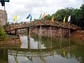
- Scene of Valapattanam River
- From Paalam
- From Kalloori
- Various hills
- Kolathuvayal
- keecheri hill
- keechery thaava
- Mankadavu JumaMasjid, Kadavu
Transportation[]
By Air[]
- The nearest Airport is Kannur International Airport to the east at an approximate distance of 33 km
By Train[]
- Nearest major Railway Station is Kannur and other nearest Railways Station is Pappinisseri and Valapattanam.
- Two trains originating from Mangalore/Trivandrum and bound for Trivandrum/Mangalore, Ernad and Malabar express, stop at Valapattanam.
- All passenger trains stop at Valapattanam and Pappinisseri.
- All the trains runs through this line including New Delhi-Trivandrum Rajdhani Express, stop at Kannur.[8][9][10][11][12][13][14][15]
By Bus[]
- From Kannur :
- 1) Board any bus going to Pazhayangadi for Moonnu Pettumma Palli and Western Part of Pappinisseri
- 2) Board any bus going to Taliparamba for Keecheri and Eastern Part of Pappinisseri
- 3) Board any bus going to Parassinikkadavu via Mankadavu for Aroli village area.
- 4) board any bus going anchampeedika for keecheri village area
Mangroves Park, Pappinisseri[]


References[]
- ^ "Census of India Search details". censusindia.gov.in. Retrieved 10 May 2015.
- ^ "Census of India 2001: Data from the 2001 Census, including cities, villages and towns (Provisional)". Census Commission of India. Archived from the original on 16 June 2004. Retrieved 1 November 2008.
- ^ Falling Rain Genomics, Inc - Pappinisseri
- ^ Kerala, Directorate of Census Operations. District Census Handbook, Kannur (PDF). Thiruvananthapuram: Directorateof Census Operations,Kerala. p. 186,187. Retrieved 14 July 2020.
- ^ "Religion – Kerala, Districts and Sub-districts". Census of India 2011. Office of the Registrar General.
- ^ https://timesofindia.indiatimes.com › ... Web results Pappinissery-Pilathara KSTP road formally inaugurated | Kochi News - Times of India
- ^ "Only Centre can end Kannur violence: High Court". The Hindu. Chennai, India. 12 March 2008. Archived from the original on 15 March 2008.
- ^ "Railway Time Table No 26 : Gandhidham-Nagercoil" (PDF). Retrieved 13 July 2010.
- ^ "Railway Time Table No 26A : Nagercoil-Gandhidham" (PDF). Retrieved 13 July 2010.
- ^ "Railway Time Table No 26-1 : Monsoon Timing Gandhidham-Nagercoil" (PDF). Retrieved 13 July 2010.
- ^ "Railway Time Table No 26-1A : Monsoon Timing Nagercoil-Gandhidham" (PDF). Retrieved 13 July 2010.
- ^ "Railway Time Table No 86 : Chennai-Mangalore" (PDF). Retrieved 13 July 2010.
- ^ "Railway Time Table No 86A : Mangalore-Chennai" (PDF). Retrieved 13 July 2010.
- ^ "Railway Time Table No 85 : Nagercoil-Mangalore" (PDF). Retrieved 13 July 2010.
- ^ "Railway Time Table No 85A : Mangalore-Nagercoil" (PDF). Retrieved 13 July 2010.
External links[]
| Wikimedia Commons has media related to Pappinisseri. |
| show |
|---|
- Cities and towns in Kannur district