Palakkad
Palakkad
Palghat | |
|---|---|
City | |
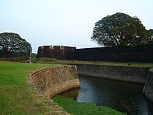
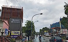
 From top clockwise: Palakkad Municipal Office, IMA Junction, road near Palakkad KSRTC bus station, Chandranagar roundabout, Aerial view from Olavakkode | |
 Palakkad | |
| Coordinates: 10°46′30″N 76°39′04″E / 10.775°N 76.651°ECoordinates: 10°46′30″N 76°39′04″E / 10.775°N 76.651°E | |
| Country | |
| State | Kerala |
| District | Palakkad |
| Government | |
| • Type | Municipality |
| • Body | Palakkad Municipality |
| • Chairperson | K. Priya Ajayan (BJP) |
| • Deputy Chairman | E. Krishnadas (BJP) |
| • Member of Parliament | V. K. Sreekandan (INC) |
| • Member of Legislative Assembly | Shafi Parambil (INC) |
| Area | |
| • City | 26.60 km2 (10.27 sq mi) |
| • Metro | 1,363 km2 (526 sq mi) |
| Elevation | 84 m (276 ft) |
| Population (2011) | |
| • City | 130,955 |
| • Density | 4,900/km2 (13,000/sq mi) |
| • Metro | 293,533 |
| Demonym(s) | Palakkadan |
| Language | |
| • Official | Malayalam |
| Time zone | UTC+5:30 (IST) |
| Postal Index Number | 678 XXX |
| Area code(s) | +91-(0)491 |
| Vehicle registration | KL-09 |
| Climate | Am/Aw (Köppen) |
| Website | www |


Palakkad,(Malayalam: [pɐːlɐkːɐːɖɨ̆] (![]() listen)), also known as Palghat, is a city and municipality in the state of Kerala in India. It is spread over an area of 26.60 square kilometres (10.27 sq mi). It is the administrative headquarters of the Palakkad District. The city is situated about 350 kilometres (220 mi) north of state capital Thiruvananthapuram, 50 kilometres (31 mi) southwest of Coimbatore in Tamil Nadu, 66 kilometres (41 mi) northeast of Thrissur, and 127 kilometres (79 mi) southeast of Kozhikode, on the meeting point of two National Highways namely, Salem-Kochi National Highway NH 544, and Kozhikode-Malappuram-Palakkad National Highway NH 966. Palakkad is also known as the rice bowl of Kerala. The 18th-century Palakkad Fort has sturdy battlements, a moat, and a Hanuman temple on its grounds. North on the Kalpathy River, the 15th-century Viswanatha Swamy Temple is the main venue of the Ratholsavam chariot festival. Northeast, near Malampuzha Dam, the town of Malampuzha has a rock garden created from recycled materials. The river Bharathappuzha flows through Palakkad.[3] Palakkad is located on the northern bank of Bharathappuzha River.[3]
listen)), also known as Palghat, is a city and municipality in the state of Kerala in India. It is spread over an area of 26.60 square kilometres (10.27 sq mi). It is the administrative headquarters of the Palakkad District. The city is situated about 350 kilometres (220 mi) north of state capital Thiruvananthapuram, 50 kilometres (31 mi) southwest of Coimbatore in Tamil Nadu, 66 kilometres (41 mi) northeast of Thrissur, and 127 kilometres (79 mi) southeast of Kozhikode, on the meeting point of two National Highways namely, Salem-Kochi National Highway NH 544, and Kozhikode-Malappuram-Palakkad National Highway NH 966. Palakkad is also known as the rice bowl of Kerala. The 18th-century Palakkad Fort has sturdy battlements, a moat, and a Hanuman temple on its grounds. North on the Kalpathy River, the 15th-century Viswanatha Swamy Temple is the main venue of the Ratholsavam chariot festival. Northeast, near Malampuzha Dam, the town of Malampuzha has a rock garden created from recycled materials. The river Bharathappuzha flows through Palakkad.[3] Palakkad is located on the northern bank of Bharathappuzha River.[3]
Palakkad municipality was formed on 1 November 1866 according to the Madras Act 10 of 1865 (Amendment of the Improvements in Towns act 1850)[4][5][6][7] of the British Indian Empire, making it the second oldest municipality in the state.
Etymology
The commonly held belief is that the name Palakkad is a fusion of two Malayalam words: Pāla, which is local name for blackboard tree (Alstonia scholaris), and Kātŭ, which means forest.[8]
History
The region around Coimbatore was ruled by the Cheras during Sangam period between c. 1st and the 4th centuries CE and it served as the eastern entrance to the Palakkad Gap, the principal trade route between the Malabar Coast and Tamil Nadu.[9] Palakkad city was ruled by the Palakkad Rajas (Tarur Swaroopam).[10] Palakkad Raja had the right over the Taluks of Palakkad, Alathur, and Chittur.[10] The original headquarters of Palakkad Rajas were at Athavanad, Tirur Taluk, in present-day Malappuram district.[10] It is said that their lands at Athavanad area were given to the Azhvanchery Thamprakkal and the Palakkad-Chittur areas were bought from them instead.[10] The territory of Palakkad Rajas had been under the Zamorin of Calicut for a long time.[10]
In 1757, to resist the invasion of the Zamorin of Kozhikode, the Palakkad Raja sought the help of the Hyder Ali of Mysore.[11] In 1766, Hyder Ali defeated the Zamorin of Kozhikode – an East India Company ally at the time – and absorbed Kozhikode into his state.[11] The Hyder Ali rebuilt Palakkad Fort in 1766.[12] The smaller princely states in northern and north-central parts of Kerala (Malabar District) including Kolathunadu, Kottayam, Kadathanadu, Kozhikode, Tanur, Valluvanad, and Palakkad were unified under Mysore and were made a part of the larger Kingdom of Mysore.[13] His son and successor, Tipu Sultan, launched campaigns against the expanding British East India Company, resulting in two of the four Anglo-Mysore Wars.[14][15]
Tipu ultimately ceded the Malabar District and South Kanara to the company in the 1790s as a result of the Third Anglo-Mysore War and the subsequent Treaty of Seringapatam; both were annexed to the Bombay Presidency (which had also included other regions in the western coast of India) of British India in the years 1792 and 1799 respectively.[16][17][18] Later in 1800, both of the Malabar District and South Canara were separated from Bombay presidency to merge them with the neighbouring Madras Presidency.[12] Palakkad was under British Raj until 1947.
The municipality of Palakkad was formed on 1 November 1866 according to the Madras Act 10 of 1865 (Amendment of the Improvements in Towns act 1850)[4][5][6][7] of the British Indian Empire, along with the municipalities of Kozhikode, Kannur, Thalassery, and Fort Kochi, making them the first modern municipalities in the modern state of Kerala.
At the time of 1951 Census of India, Palakkad was the second-largest city in the erstwhile Malabar District after Kozhikode.[19] At that time only two towns in Malabar was treated as cities: Kozhikode and Palakkad.[19] Following the formation of the state of Kerala in 1956, the erstwhile Taluk of Palakkad in Malabar District was divided into three: Palakkad, Alathur, and Chittur, and Palakkad district was formed by taking parts of erstwhile Malabar District.[12]
Geography

Palakkad is the gateway to Kerala due to the presence of the Palakkad Gap in the Western Ghats. Malayalam is the official language in Palakkad. The district has many small and medium rivers, which are tributaries of the Bharathapuzha River. Of the numerous dams in Palakkad district, the largest Malampuzha dam is 12 kilometres (7.5 mi) from Palakkad city.[20]
Climate
Palakkad has a tropical wet and dry climate. Temperatures remain moderate throughout the year, with the exception being March and April, the hottest months. A very high amount of precipitation is received in Palakkad, mainly due to the South-West monsoon. July is the wettest month, and the total annual rainfall is around 83 inches (210 cm).
| hideClimate data for Palakkad (1981–2010, extremes 1943–2005) | |||||||||||||
|---|---|---|---|---|---|---|---|---|---|---|---|---|---|
| Month | Jan | Feb | Mar | Apr | May | Jun | Jul | Aug | Sep | Oct | Nov | Dec | Year |
| Record high °C (°F) | 37.6 (99.7) |
40.0 (104.0) |
41.4 (106.5) |
41.8 (107.2) |
41.2 (106.2) |
40.4 (104.7) |
33.6 (92.5) |
33.8 (92.8) |
35.8 (96.4) |
36.2 (97.2) |
38.0 (100.4) |
36.6 (97.9) |
41.8 (107.2) |
| Average high °C (°F) | 32.7 (90.9) |
35.2 (95.4) |
37.3 (99.1) |
36.6 (97.9) |
34.5 (94.1) |
29.9 (85.8) |
28.8 (83.8) |
28.9 (84.0) |
30.4 (86.7) |
31.5 (88.7) |
31.6 (88.9) |
31.5 (88.7) |
32.4 (90.3) |
| Average low °C (°F) | 22.0 (71.6) |
22.4 (72.3) |
24.1 (75.4) |
25.0 (77.0) |
24.8 (76.6) |
23.2 (73.8) |
22.6 (72.7) |
23.0 (73.4) |
23.0 (73.4) |
23.1 (73.6) |
23.1 (73.6) |
22.3 (72.1) |
23.2 (73.8) |
| Record low °C (°F) | 15.6 (60.1) |
15.8 (60.4) |
18.6 (65.5) |
18.8 (65.8) |
19.2 (66.6) |
19.0 (66.2) |
18.8 (65.8) |
19.2 (66.6) |
19.4 (66.9) |
15.8 (60.4) |
16.1 (61.0) |
14.0 (57.2) |
14.0 (57.2) |
| Average rainfall mm (inches) | 3.6 (0.14) |
3.6 (0.14) |
15.7 (0.62) |
61.3 (2.41) |
125.1 (4.93) |
410.6 (16.17) |
453.2 (17.84) |
290.3 (11.43) |
154.9 (6.10) |
196.1 (7.72) |
102.3 (4.03) |
21.3 (0.84) |
1,838 (72.36) |
| Average rainy days | 0.3 | 0.3 | 0.9 | 3.3 | 5.9 | 18.7 | 20.0 | 15.8 | 9.2 | 10.1 | 4.7 | 0.9 | 90.1 |
| Average relative humidity (%) (at 17:30 IST) | 46 | 39 | 38 | 52 | 60 | 79 | 82 | 81 | 75 | 73 | 65 | 56 | 61 |
| Source: India Meteorological Department[21][22] | |||||||||||||
Transport
Air
The nearest international airport is Coimbatore International Airport, which is about 62 kilometres (39 mi) from Palakkad. However, Cochin International Airport and Calicut International Airport serve the city as well.
There has been a proposal for a mini domestic airport at East Yakkara with respect to setting up domestic airports for enhanced air connectivity by the civil aviation ministry of India. 60 acres has been identified for the project at East Yakkara Palakkad.[23]


Railways
The Palakkad railway division is one of the six administrative divisions of the Southern Railway zone of Indian Railways, headquartered at Palakkad. It is the smallest railway division in Southern Railway. It was formed by dissolving the Podanur division. Managing 588 route kilometers of track in the states of Kerala, Tamil Nadu, Karnataka and Mahé (in the Union Territory of Puducherry), it is one of the oldest railway divisions in India. The major stations under this railway division are Palakkad Junction, Shoranur Junction, Ottapalam, Tirur, Kozhikode, Thalassery, Kannur, Kasaragod, Mangalore Central, Mangalore Junction and Pollachi Junction. The terminal facility of Palakkad division is situated in Shoranur Junction & Mangalore Central of Karnataka state. It is the only division headquarters in India with no originating train to its state capital.
Palakkad is the HQ of the Palakkad Railway Division of Southern Railway Zone. The city is served by two railway stations – Palakkad Junction is a broad gauge railway junction (located at Olavakkode, about 4 km from Municipal bus stand) and Palakkad Town railway station located in the heart of the Palakkad city. The cities of Coimbatore, Tiruchirappalli, Erode, Salem, Thiruvananthapuram, Kollam, Mangalore, Kozhikode and Ernakulam are connected by the broad gauge line. Train services to Pollachi, Dindigul and Madurai are through the broad gauge line through Palakkad Town station.[24] Shoranur Junction Railway Station also has rail connections to Mangalore and the Konkan Railway, enabling travel towards Goa and Bombay. The trains coming from other parts of India are diverted to the north and south Kerala from Shoranur Junction in Palakkad District. From here, there is train service to Calicut, Ernakulam, Trivandrum, Shoranur and Nilambur.
Road
Palakkad has a medium-grade network of roads. The National Highway 544 from Salem to Ernakulam via Coimbatore, Palakkad and Thrissur – Kozhikode National Highway 966 via Malappuram merges with NH 544 in the city.[25] The other important roads are the Palakkad – Ponnani road which connects NH 66 and Mumbai-Kanyakumari coastal NH 66, State Highway 52 begins near the Chandra nagar junction, which is 2.6 km from the city centre, which connects to Pollachi, and State Highway 27 begins at the center of the city which connects to Meenakshipuram (Kerala-Tamil Nadu State Border).
Palakkad City has four Bus Stations includes and three Private Bus stands named Stadium Bus Stand, Municipal Bus stand, and Town Bus Stand.
Demographics
As per Census 2011, population of Palakkad in 2011 is 130,955; of which male and female are 63,833 and 67,122 respectively.[26]
Total literates in Palakkad city are 112,479, of which 56,065 are males while 56,414 are females. The average literacy rate of Palakkad city is 94.20 percent of which male and female literacy was 96.83 and 91.73 percent. The literacy rate of the Palakkad Metropolitan Area is 92.14%, much higher than the national average of 59.5%.[27][28]
Hindus form 68% of the population with 89098 members.[26] Muslims constitute 27.9% of the population with 36620 members.[26] Christians constitute 3.8% of the population with 5006 members.[26]
Civic Administration
Palakkad is a municipality with elected councilors from 52 Wards.[29] The municipality of Palakkad was formed on 1 November 1866 according to the Madras Act 10 of 1865. (Amendment of the Improvements in Towns act 1850).[30] The city is administrated by municipality and headed by Municipal Chairperson. The current Chairperson of Palakkad Municipality is K.Priya Ajayan and E. Krishnadas is the Deputy Chairman.
Economy


The presence of Palakkad Gap and proximity to Coimbatore make Palakkad economically important. Palakkad city is one of the largest industrial hubs in Kerala. Kanjikode area of Palakkad city is the second industrial hub of Kerala after Kochi. Kanjikode is one of the largest industrial areas in Kerala and companies like Indian Telephone Industries Limited (ITI), Instrumentation Limited, Fluid Control Research Institute, Saint-Gobain India Private Limited (formerly SEPR Refractories India Private Limited), Patspin India Ltd, Pepsi, PPS steel (Kerala) Pvt Ltd, United breweries, Empee Distilleries, Marico, Bharat Earth Movers Limited (BEML), Rubfila International Ltd, Arya Vaidya Pharmacy have production facilities. The commercialization of Palakkad City is Picking up and growing at steady pace in recent years, Nowadays Palakkad City and the suburbs are witnessing rapid amount of commercial and public development activities. The developments are mainly concentrated on the bypass roads, Both Stadium and Calicut bypass roads passing through city are getting major commercial projects. Major national and international branded Retail chains, food Chains, Restaurants, Hotels, Shopping complexes, Textiles, branded jewellers, Vehicle Showrooms, are functioning in and around city. There are many housing colonies consist of Villas and apartments are also present in Palakkad City and suburbs.
Governance
On 3 July 1866, the Governor of Madras declared Palakkad as a city.[31] On 11 September 1912, the system of electing the city father by the councillors began.[31] City Council expanded to 28 wards in 1938, 32 wards in 1973 and 36 wards in 1978.[31]
Proposed Palakkad Municipal Corporation
The metropolitan area of Palakkad includes , Marutharode, Palakkad Municipality, Pirayiri, Pudussery West, Pudussery Central and Puthupariyaram.[28] Its urban / metropolitan population is 293,566 of which 143,650 are males and 149,916 are females. There is demand to upgrade Palakkad Municipality into a Municipal Corporation by adding the Outgrowth areas and nearby Urban Local bodies to the Palakkad Corporation.
- Palakkad Municipality
- Pirayiri
- Marutharode
- Puthupariyaram
- Akathethara
- Pudussery Central
- Pudussery West
- Mathur
- Kodumba (Urban areas only)
- Kannadi (Urban areas only)
- Malampuzha (excluding rural and forest areas)[32]
Palakkad Taluk
Education in Palakkad
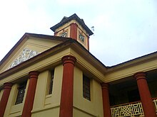


Palakkad City has number of Prominent Educational Institutions which provide a great platform for higher education. Government Victoria College, Palakkad was established in the year 1866, making it one of the oldest institution of higher learning in Palakkad.
Palakkad city is home to the only Indian Institute of Technology in the state of Kerala. The Indian Institute of Technology was founded in 2015, the campus currently functions in two campuses-temporary and the Nila campus which are separated by 13 km.
[33]IIT Palakkad[34]]s a public autonomous engineering and research institute located in Palakkad, Kerala. It is one of the five new IITs proposed in the 2014 Union budget of India.
Government Medical College, Palakkad[35] is started in 2014 is the first Government medical college in the district. is the first medical college in country under the Kerala State Scheduled caste Development Department.
NSS College of Engineering[36] at Akathethara, is the Fourth Engineering Institution established in Kerala, India. It was founded in 1960 by Nair Service Society. The college is one among the only three Govt-Aided Engineering college in Kerala and the first Govt-Aided Engineering college accredited by NBA of AICTE.
Chembai Memorial Government Music College[37] is one of the main center of excellence in teaching Carnatic music in the state. It was given the name of the legendry Carnatic musician Chembai Vaidyanatha Bhagavathar from Palakkad.
Mercy College, Palakkad[38] a women's college established in 1964 was the first Women's college in the Palakkad District. The college is organized by the University Grants Commission.
Prominent People from Palakkad
- Kocheril R. Narayanan (former president of india)
- E Sreedharan
- P. R. Pisharoty (Kollengode, Father of remote sensing in India)
- Vidya Balan
- K P Kesava Menon
- Sudev Nair
- V P Menon
- Kunjan Nambiar
- Olappamanna
- M T Vasudevan Nair
- O V Vijayan
- Akkitham Achuthan Namboothiri
- Malayattoor Ramakrishnan
- Shashi Tharoor
- O M C Narayanan Nambudiripad
- Anita Nair
- K. S. Sethumadhavan
- Shankar Mahadevan (Playback Singer and Composer)
- M. G. Ramachandran
- P. Unnikrishnan
Media
Major Malayalam Newspapers include Malayala Manorama,Mathrubhumi, Deshabhimani, Suprabhaatham Daily, The Hindu have printing centers in city and there are also few evening newspapers published from the city. Local news channels like (ACV) are also functioning in city . Palakkad Press Club is located on Robinson road, Sultanpet. A private FM Station operating in Palakkad at Ahalia Campus. There is a long term demand for setting up a government FM Station in Palakkad. At the present total number of 8 cinema halls are operational in Palakkad which screens Malayalam, English, Tamil, Hindi movies, there are few other multiplex screens are under construction and expect to open near future in and around city.
Sports in Palakkad
Palakkad has a rich history of producing some world class athletes in the state, Palakkad, Indira Gandhi Municipal Stadium in the center of city was once used for Major sports meets and football matches in state, now the stadium is not in condition for conducting games due to the lack of maintenance, There is a proposal for the renovation of the stadium with international facilities by the Municipality ,[39] The city has Fort Maidan[40] also known as Kota Maidanam, is a multi-use stadium in the center of the Palakkad, India. It is currently used mostly for cricket matches. Fort Maidan holds a maximum capacity of 10,000 people at a time. Up till 2002 the ground was considered for local cricket only.[41] In 2003, Ranji Trophy was introduced in Fort Maidan. The city has an indoor stadium[42] located near to Government Victoria College, Palakkad with a total area of 1 Lakh Sq.ft with commercial establishments are still unfinished & incomplete. There is a Synthetic Track with Eight lines operational in the ground of newly constructed Government Medical College, Palakkad.[43]
See also
- Palakkad District
- Education in Palakkad district
- Malampuzha Dam
- Palakkad Fort
- Stadium Bus Stand
- Political Divisions of Palakkad District
References
- ^ "Thiruvananthapuram Corporation General Information". Corporation of Thiruvananthapuram. Retrieved 10 July 2018.
- ^ "Urban Agglomerations/Cities having population 1 million and above" (PDF). Office of the Registrar General & Census Commissioner. Ministry of Home Affairs, Government of India. Retrieved 9 July 2018.
- ^ Jump up to: a b DISTRICT CENSUS HANDBOOK PALAKKAD - 2011 (Part XII-B) (PDF). Thiruvananthapuram: Directorate of Census Operations, Kerala. 2011.
- ^ Jump up to: a b "Chronological List of Central Acts (Updated up to 17-10-2014)". Lawmin.nic.in. Archived from the original on 7 January 2018. Retrieved 7 August 2016.
- ^ Jump up to: a b Lewis McIver, G. Stokes (1883). Imperial Census of 1881 Operations and Results in the Presidency of Madras ((Vol II) ed.). Madras: E.Keys at the Government Press. p. 444. Retrieved 5 December 2020.
- ^ Jump up to: a b Presidency, Madras (India (1915). Madras District Gazetteers, Statistical Appendix For Malabar District (Vol.2 ed.). Madras: The Superintendent, Government Press. p. 20. Retrieved 2 December 2020.
- ^ Jump up to: a b Frowde, Henry (1908–1909). Imperial Gazetteer of India (New ed.). Oxford: Clarendon Press. Retrieved 2 December 2020.
- ^ A. Sreedhara Menon (1978). Kerala Samskāram. DC Books. p. 237. ISBN 9788126415854.
- ^ Subramanian, T. S (28 January 2007). "Roman connection in Tamil Nadu". The Hindu. Archived from the original on 19 September 2013. Retrieved 28 October 2011.
- ^ Jump up to: a b c d e Shreedhara Menon, A (2007). 'Kerala Charitram. Kottayam: DC Books. pp. 200–201. ISBN 9788126415885.
- ^ Jump up to: a b K. V. Krishna Iyer (1938), Zamorins of Calicut: From the earliest times to AD 1806, Norman Printing Bureau, Kozhikode
- ^ Jump up to: a b c A Survey of Kerala History, A. Shreedhara Menon
- ^ Raghunath Rai. History. FK Publications. pp. 14–. ISBN 978-81-87139-69-0. Retrieved 18 November 2012.
- ^ British Museum; Anna Libera Dallapiccola (22 June 2010). South Indian Paintings: A Catalogue of the British Museum Collection. Mapin Publishing Pvt Ltd. pp. 12–. ISBN 978-0-7141-2424-7. Retrieved 18 November 2012.
- ^ Edgar Thorpe, Showick Thorpe; Thorpe Edgar. The Pearson CSAT Manual 2011. Pearson Education India. p. 99. ISBN 978-81-317-5830-4. Retrieved 18 November 2012.
- ^ The Edinburgh Gazetteer. Longman, Rees, Orme, Brown, and Green. 1827. pp. 63–. Retrieved 18 November 2012.
- ^ Dharma Kumar (1965). Land and Caste in South India: Agricultural Labor in the Madras Presidency During the Nineteenth Century. CUP Archive. pp. 87–. GGKEY:T72DPF9AZDK. Retrieved 18 November 2012.
- ^ K.P. Ittaman (1 June 2003). History of Mughal Architecture Volume Ii. Abhinav Publications. pp. 30–. ISBN 978-81-7017-034-1. Retrieved 18 November 2012.
- ^ Jump up to: a b 1951 census handbook - Malabar district (PDF). Chennai: Government of Madras. 1953.
- ^ Fact sheet on Indian dams at Diehardindian.com Archived 2006-12-13 at the Wayback Machine
- ^ "Station: Palakkad (Palghat) Climatological Table 1981–2010" (PDF). Climatological Normals 1981–2010. India Meteorological Department. January 2015. pp. 581–582. Archived from the original (PDF) on 5 February 2020. Retrieved 29 February 2020.
- ^ "Extremes of Temperature & Rainfall for Indian Stations (Up to 2012)" (PDF). India Meteorological Department. December 2016. p. M109. Archived from the original (PDF) on 5 February 2020. Retrieved 29 February 2020.
- ^ "60 Acres Identified For Airport Project". The Hindu. Chennai, India. 21 May 2011. Archived from the original on 26 May 2011.
- ^ "Train services resume on Pollachi – Palakkad section". Coimbatore. The Hindu. 17 November 2015. Retrieved 25 November 2015.
- ^ "National Highways and their lengths" Archived 6 September 2012 at the Wayback Machine. National Highways Authority of India. Retrieved 4 September 2015.
- ^ Jump up to: a b c d http://www.censusindia.gov.in/2011census/C-01/DDW32C-01%20MDDS.XLS
- ^ "Palakkad – Census of India". Censusindia.gov.in. Retrieved 4 September 2015.
- ^ Jump up to: a b "Palakkad Urban Region". Census2011.co.in. Retrieved 4 September 2015.
- ^ "Local Body Elections 2020 - TREND by State Election Commission Kerala".
- ^ Imperial Census of 1881: Operations and Results in the Presidency of Madras. Government Press. 1883.
- ^ Jump up to: a b c "ആമുഖം | Palakkad Municipality". 30 December 2019. Archived from the original on 30 December 2019. Retrieved 15 September 2020.
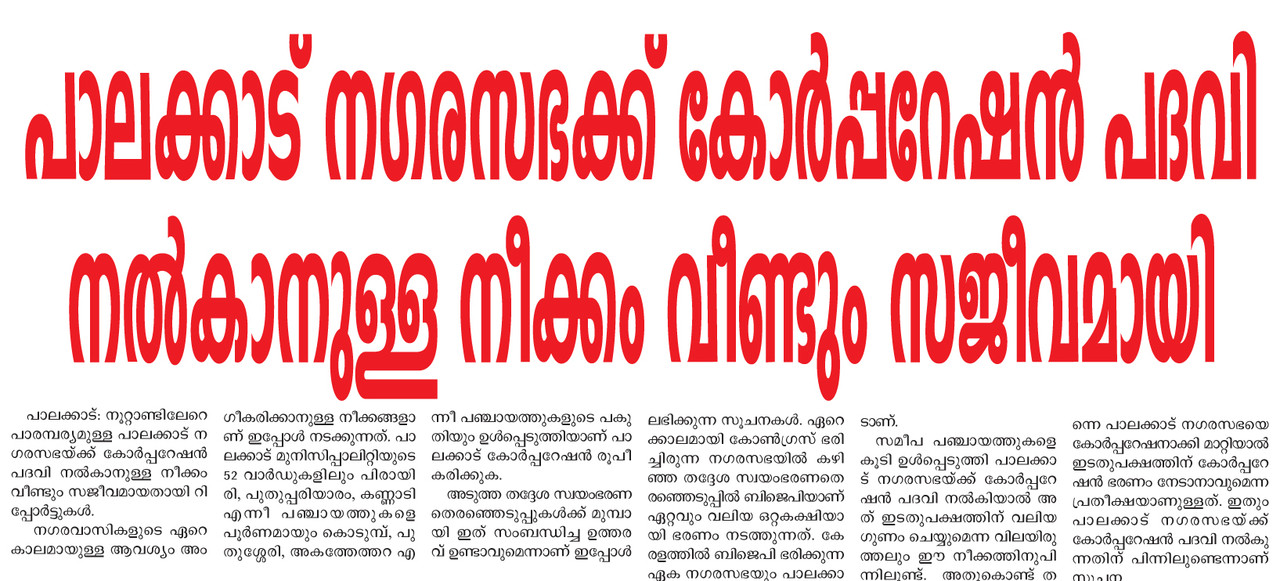
- ^ https://i.postimg.cc/MHwqnmBg/19-2-19p1.jpg
- ^ "District Profile". spb.kerala.gov.in. Retrieved 9 January 2019.
- ^ https://iitpkd.ac.in/
- ^ http://www.gmcpalakkad.in/
- ^ Official website
- ^ "借金SOS | Just another WordPress site".
- ^ https://web.archive.org/web/20170916095650/http://www.universityofcalicut.info/affiliated_colleges/2016_Affiliated_Colleges_and_courses_latest_list_on24May2016.pdf
- ^ "Palakkad municipal stadium turns into dump yard covered with weeds".
- ^ https://www.espncricinfo.com/india/content/ground/58364.html
- ^ "The Home of CricketArchive".
- ^ "Palakkad Indoor Stadium".
- ^ "Synthetic track for Palakkad". The Hindu. 7 September 2015.
External links
| Wikimedia Commons has media related to Palakkad. |
 Palakkad travel guide from Wikivoyage
- http://www.palakkad.gov.in – Official Website of Palakkad District Administration
- http://www.palakkadtourism.org – Palakkad District Tourism-Information
| show |
|---|
| show Authority control |
|---|
- Palakkad
- Cities and towns in Palakkad district