Paytakaran

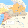
Paytakaran (Armenian: Փայտակարան Pʿaytakaran) was the easternmost province of the Kingdom of Armenia.[1][2][3] The province was located in the area of the lower courses of the rivers of Kura and Araks, adjacent to the Caspian sea. Today, the area is located in the territory of modern-day southeastern Azerbaijan and northwestern Iran.
Paytakaran town was the centre of the province.
Etymology[]
"The land of Pʿayt", applied by Medians to this territory to their north, from Median *karan- (border, region, land). The Pʿayt is probably a name of a Caspian tribe. See also Lankaran. Payt also means "wood" in Armenian.
Province of Armenia Major[]
The Armenians acquired the region in the 2nd century BC.[4] According to Anania Shirakatsi's Ashkharatsuyts ("World Atlas," 7th century AD), Paytakaran was the 11th among the 15 provinces of the Kingdom of Armenia. It was located to the east of Utik on Araxes and was divided into 12 cantons (gavars), which were at the time in possession of Adurbadagan:[2]
- Hrakot-Perozh (centre: Paytakaran)
- Vardanakert (centre: Vardanakert)
- Rot-i-Bagha
- Hani
- Atshi-Bagavan (centre: Bagavan)
- Kaghan-Rot
- Koekyan
- Aros
- Vormizd-Perozh
- Pichan (centre: Pichan)
- Spandaran-Perozh (centre: Spandaran)
- Alevan (centre: Alevan)
History[]
Prior to becoming Paytakaran, the region was known as Caspiane by Greco-Roman authors. Caspiane was contested between the regional powers. According to Strabo: "To the country of the Albanians belongs also the territory called Caspiane, which was named after the Caspian tribe, as was also the sea; but the tribe has now disappeared."[1] Strabo also mentions Caspiane among the lands conquered by king Artashes I from Medes in the 2nd century BC. However, Armenia later lost it to Caucasian Albania about 59 BC, when Pompey rearranged the political geography of the region,[5] but the region was again conquered by the Armenians. In the 360s AD, a fierce rebellion engulfed Paytakaran but it was later put down by sparapet Mushegh Mamikonian. After the partition of Armenia in 387, it remained a part of eastern Armenia until 428 (following the dissolution of the Armenian Arshakuni kingdom)[3] and was added to Adurbadagan.[3] The region was non-Armenian by ethnic composition.[6] The population apparently consisted of Caucasian and Iranian speakers.
References[]
- ^ a b Strabo, Geography, 11.14. Persus Digital Library.
- ^ a b Anania Shirakatsi. Geography.
- ^ a b c (in Armenian) Harutyunyan, Babken. «Փայտակարան» (Paytakaran). Soviet Armenian Encyclopedia. vol. xii. Yerevan, Armenian SSR: Armenian Academy of Sciences, 1986, pp. 301-302.
- ^ Hewsen, Robert H. Armenia: A Historical Atlas. Chicago: University Of Chicago Press, 2000. ISBN 0-226-33228-4, p. 102
- ^ Redgate, Anna Elizabeth. The Armenians (Peoples of Europe). Cornwall: Blackwell Publishers, 1998, ISBN 0-631-22037-2.
- ^ Hewsen. Armenia, p. 102.
Historical states and regions of Armenia | ||
|---|---|---|
| Independent Armenian states |
|  |
| Minor or dependent Armenian states |
| |
| Provinces or Ashkhars of Armenia Major | ||
| Other Armenian regions |
| |
| Other provinces under Tigranes the Great |
| |
- Provinces of the Kingdom of Armenia (antiquity)
- History of Talysh