Pence (CDP), Wisconsin
Pence, Wisconsin | |
|---|---|
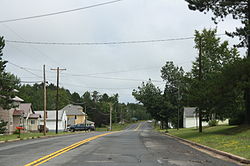 Looking east in downtown Pence | |
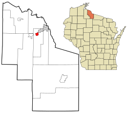 Location in Iron County and the state of Wisconsin. | |
| Coordinates: 46°24′55″N 90°16′18″W / 46.41528°N 90.27167°WCoordinates: 46°24′55″N 90°16′18″W / 46.41528°N 90.27167��W | |
| Country | United States |
| State | Wisconsin |
| County | Iron |
| Town | Pence |
| Area | |
| • Total | 1.068 sq mi (2.77 km2) |
| • Land | 1.068 sq mi (2.77 km2) |
| • Water | 0 sq mi (0 km2) |
| Elevation | 1,631 ft (497 m) |
| Population (2010) | |
| • Total | 131 |
| • Density | 120/sq mi (47/km2) |
| Time zone | UTC-6 (Central (CST)) |
| • Summer (DST) | UTC-5 (CDT) |
| Area code(s) | 715 & 534 |
| GNIS feature ID | 1571168[1] |


Sign for Pence on WIS77

Water tower
Pence is an unincorporated census-designated place located in the town of Pence, Iron County, Wisconsin, United States. Pence is located on Wisconsin Highway 77 1.5 miles (2.4 km) southwest of Montreal. As of the 2010 census, its population is 131.[2]
References[]
| Wikimedia Commons has media related to Pence, Wisconsin. |
- ^ U.S. Geological Survey Geographic Names Information System: Pence (CDP), Wisconsin
- ^ "U.S. Census website". U.S. Census Bureau. Retrieved 17 April 2011.
Municipalities and communities of Iron County, Wisconsin, United States | ||
|---|---|---|
| Cities |  | |
| Towns | ||
| CDPs | ||
| Unincorporated communities | ||
| Indian reservations | ||
| Footnotes | ‡This populated place also has portions in an adjacent county or counties | |
| ||
This article about a location in Iron County, Wisconsin is a stub. You can help Wikipedia by . |
Categories:
- Census-designated places in Iron County, Wisconsin
- Census-designated places in Wisconsin
- Northern Wisconsin geography stubs