Penetanguishene
Penetanguishene | |
|---|---|
Town (lower-tier) | |
| Town of Penetanguishene Ville de Penetanguishene | |
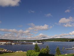 Town docks on Penetanguishene Bay. | |
 Penetanguishene | |
| Coordinates: 44°46′N 79°56′W / 44.767°N 79.933°WCoordinates: 44°46′N 79°56′W / 44.767°N 79.933°W | |
| Country | Canada |
| Province | Ontario |
| County | Simcoe |
| Incorporated | February 22, 1882 |
| Government | |
| • Mayor | Douglas R. Leroux |
| • MPs | Bruce Stanton |
| • MPPs | Jill Dunlop |
| Area | |
| • Land | 25.58 km2 (9.88 sq mi) |
| Population (2016)[2] | |
| • Total | 8,962 |
| • Density | 350.3/km2 (907/sq mi) |
| Time zone | UTC-5 (Eastern (EST)) |
| • Summer (DST) | UTC-4 (EDT) |
| Forward sortation area | L9M |
| Area code(s) | 705 |
| Website | www |


Penetanguishene /pɛnɪˈtæŋɡwɪʃiːn/ (![]() listen), sometimes shortened to Penetang, is a town in Simcoe County, Ontario, Canada. It is located on the southeasterly tip of Georgian Bay. Incorporated on February 22, 1882, this bilingual (French and English) community has a population of 8,962 in the Canada 2016 Census.
listen), sometimes shortened to Penetang, is a town in Simcoe County, Ontario, Canada. It is located on the southeasterly tip of Georgian Bay. Incorporated on February 22, 1882, this bilingual (French and English) community has a population of 8,962 in the Canada 2016 Census.
The name Penetanguishene is believed to come from either the Wyandot[3] or Abenaki via Ojibwe,[4] meaning "land of the white rolling sands".
History[]
As early as AD 800, the Wyandot people settled in semi-permanent villages in the area. The young French translator, Étienne Brûlé, was the first European to set foot in the Penetanguishene area, some time between 1610 and 1614. He died in 1633 in Toanche, just across the bay from the modern town of Penetanguishene.
In 1793, John Graves Simcoe, the first Lieutenant Governor of Upper Canada, visited the area and saw the location's potential as a naval base. He wanted to use the bay to shelter warships to protect British interests on lakes Huron, Erie and Michigan. Beginning in 1814, the British-Canadians built the Penetanguishene Road to provide the area a land route to Barrie and Toronto, as it was previously accessible only by water transport along the rivers or across Georgian Bay.
In 1817, naval units from Michilimackinac and Schooner Town (near modern-day Wasaga Beach) were consolidated at the Penetanguishene Naval Yard. But, because treaty limitations with the U.S. limited both countries' naval power on the Great Lakes, two British armed topsail schooners, and were laid up "in ordinary", and eventually reported to have sunk at their moorings in the harbour in 1828. Some other small craft were headquartered in Penetanguishene for the exploration and mapping of the Great Lakes' coastline.
In 1828, the main British military establishment on the Upper Lakes moved from Drummond Island to Penetanguishene. Families of fur traders who had moved with the British from Michilimackinac to Drummond Island after the War of 1812, moved again to Penetanguishene. They settled in the town and the surrounding area. Although the naval base was closed in 1834, the military base remained until 1856. Some of the troops settled in the area after their service was complete providing an English-speaking population.
In the 1840s, French-speaking families from Quebec (mainly from the area immediately east of Montreal), attracted by promises of cheap and fertile land, joined the French-speaking Drummond Island settlers already in the area. Later, as the logging industry began to develop, more English-speaking settlers arrived. Penetanguishene became the local market and meeting place for these individuals. Many of Penetanguishene's families today are descended from the Québécois settlers who arrived in the 1800s, giving the town a marked bilingual nature.
Economy[]
Penetanguishene has several light industrial businesses mainly dealing with plastic and aluminum containers, though CCL which makes aluminum containers announced the closing of its facilities in 2013. It is host to the Central North Correctional Centre. In addition there is the Waypoint Centre for Mental Health Care which includes a high security forensic psychiatric unit for people declared to be not criminally responsible for dangerous offences but considered unsafe to be allowed in the community.[5]
Tourism occupies a considerable portion of the economy with five marinas and shops and restaurants catering to the tourist trade. In the winter, snowmobiling and ice fishing is popular and there is a mid-Winter carnival.
Tourism and sights[]
The historic naval and military base (now called Discovery Harbour) near Penetanguishene is open to visitors. There are reconstructed buildings from the historic Penetanguishene Naval Yard and two replica sailing ships from the 1812 period, HMS Bee and HMS Tecumseth (c. 1994). The ships no longer sail with passengers but they may be visited in the harbour. The original HMS Tecumseth was raised in 1953 and preserved at a nearby display area.
The King's Wharf Theatre located at Discovery Harbour has a programme of popular plays and musicals every summer.
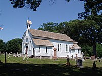
There are two notable and historic churches located in Penetanguishene. The oldest is St. James on-the-Lines, a small wooden Anglican church built in 1836 to serve the military garrison and civilian population. The most prominent is the large limestone Roman Catholic church named St. Anne's. Originally named "Ste Anne's Jesuit Memorial Church: Canadian National Shrine", it is sometimes referred to today as the "Cathedral of the North". The Church was constructed between 1886 and 1902 by pastor Theophile Francis Laboureau. Laboureau secured major funding for the church from the Bishops of Rouen and Normandy in France as well as the governments of England, France and the United States.[6] As it serves a bilingual Catholic community, services are held in both French and English.[7]
Education[]
Penetanguishene has five different school boards within its limits — the publicly funded English board (Simcoe County District School Board), which runs James Keating Elementary School; the French Catholic School Board Conseil scolaire de district catholique Centre-Sud, which operates École élémentaire catholique Saint-Louis; the Public French School Board, the Conseil scolaire Viamonde and the English Catholic School Board. The town is also home to the province's last remaining Protestant Separate school board, Penetanguishene Protestant Separate School Board.
From 1995 to 2001, the town was home to a satellite campus of the defunct francophone Collège des Grands-Lacs.[8]
Sports[]
Penetanguishene is home to the Penetang Kings of the Provincial Junior Hockey League. They are in the Carruthers division in the Ontario Hockey Association.
Demographics[]
| Year | Pop. | ±% |
|---|---|---|
| 2001 | 8,316 | — |
| 2006 | 9,354 | +12.5% |
| 2011 | 9,111 | −2.6% |
| 2016 | 8,962 | −1.6% |
| [1][2] | ||
| hideCanada census – Penetanguishene community profile | |||
|---|---|---|---|
| 2016 | 2011 | 2006 | |
| Population: | 8,962 (-1.6% from 2011) | 9,111 (-2.6% from 2006) | 9,354 (+12.5% from 2001) |
| Land area: | 25.58 km2 (9.88 sq mi) | 25.57 km2 (9.87 sq mi) | 25.38 km2 (9.80 sq mi) |
| Population density: | 350.3/km2 (907/sq mi) | 356.4/km2 (923/sq mi) | 368.6/km2 (955/sq mi) |
| Median age: | 49.9 (M: 46.7, F: 51.9) | 42.9 (M: 41.5, F: 44.2) | |
| Total private dwellings: | 3,990 | 3,923 | 3,685 |
| Median household income: | $59,738 | $51,666 | |
| References: 2016[9] 2011[10] 2006[11] earlier[12] | |||
The town has a significant concentration of Franco-Ontarians. It is one of only three communities in Central and Southwestern Ontario where the population of francophones exceeds the provincial average of five percent, the other two being Welland and Lakeshore. The town is also 12.6% Métis, compared to the provincial average of 0.6%.
Media[]
The town is home to a francophone community radio station, CFRH-FM (Vague FM), but is otherwise served by media based in the neighbouring town of Midland.
Notable people[]
- Bert Corbeau, hockey player
- Patrick DesRochers, hockey player
- Glenn Howard, World champion curler
- Russ Howard, Olympic curling gold medallist
- Chris Kontos, NHL hockey player
- James LaBrie, vocalist of progressive metal band Dream Theater
- Phil Marchildon, baseball pitcher
- Tim Mason, lawn bowler
- Peggy McIntaggart, Playboy Playmate (Miss January 1990)
- John Moberly, Naval Officer
- Brian Orser, figure skater
- Alfred B Thompson, first Canadian POW of World War II and a survivor of the Stalag Luft III escape
- Alfred Burke Thompson, MLA (now MPP) and MP
See also[]
- List of francophone communities in Ontario
References[]
- ^ Jump up to: a b "Penetanguishene census profile". 2011 Census of Population. Statistics Canada. 8 February 2012. Retrieved 2012-03-06.
- ^ Jump up to: a b "Census Profile, 2016 Census: Penetanguishene". Statistics Canada. 8 February 2017. Retrieved July 6, 2019.
- ^ Education Day: Canadian Aboriginal Festival. November 25, 2005. Elementary Teachers' Federation of Ontario.[permanent dead link]
- ^ Osborne, A. C. "Old Penetanguishene: Sketches of its Pioneer, Naval and Military Days" in Pioneer Papers, No. 5. Simcoe County Pioneer and Historical Society (Barrie, ON: 1912).
- ^ Penetanguishene Town website - Business Directory
- ^ St. Anne's of Penetanguishene: Huronia's First Mission by David Dupuis
- ^ "Penetanguishene - Attractions". Town of Penetanguishene. Archived from the original on 2013-06-28. Retrieved 2013-06-02.
- ^ "New college goes hi-tech". Windsor Star, August 28, 1995.
- ^ "2016 Community Profiles". 2016 Canadian Census. Statistics Canada. February 21, 2017. Retrieved 2019-07-06.
- ^ "2011 Community Profiles". 2011 Canadian Census. Statistics Canada. July 5, 2013. Retrieved 2012-03-06.
- ^ "2006 Community Profiles". 2006 Canadian Census. Statistics Canada. March 30, 2011. Retrieved 2012-03-06.
- ^ "2001 Community Profiles". 2001 Canadian Census. Statistics Canada. February 17, 2012.
External links[]
| Wikimedia Commons has media related to Penetanguishene. |
| show Places adjacent to Penetanguishene |
|---|
| show Authority control |
|---|
- Penetanguishene
- Lower-tier municipalities in Ontario