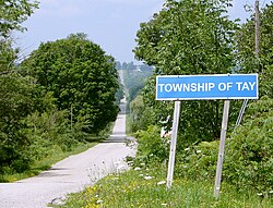
Tay, Ontario
Tay | |
|---|---|
Township (lower-tier) | |
| Township of Tay | |
 | |
 Tay | |
| Coordinates: 44°43′N 79°46′W / 44.717°N 79.767°WCoordinates: 44°43′N 79°46′W / 44.717°N 79.767°W | |
| Country | |
| Province | |
| County | Simcoe |
| Incorporated | 1994 |
| Government | |
| • Mayor | Ted Walker |
| • MPs | Bruce Stanton |
| • MPPs | Jill Dunlop |
| Area | |
| • Total | 139.07 km2 (53.70 sq mi) |
| Population (2016)[2] | |
| • Total | 10,033 |
| • Density | 72.1/km2 (187/sq mi) |
| Time zone | UTC-5 (Eastern (EST)) |
| • Summer (DST) | UTC-4 (EDT) |
| Area code(s) | 705, 249 |
| Website | www.tay.ca |


Tay is a township in Central Ontario, Canada, located in Simcoe County in the southern Georgian Bay region. The township was named in 1822 after a pet dog of Lady Sarah Maitland (1792–1873), wife of Sir Peregrine Maitland, Lieutenant Governor of Upper Canada. Two other adjoining townships were also named for her pet dogs, Tiny and Flos (now Springwater Township).[3]
History[]
In 1994, under countywide municipal restructuring, the Villages of Port McNicoll and Victoria Harbour were amalgamated with Tay.
Communities[]
The township comprises the villages and rural hamlets of Ebenezer, Elliots Corners, Melduf, Mertzs Corners, Ogden's Beach, Old Fort, Paradise Point, Port McNicoll, Riverside, Sturgeon Bay, Triple Bay Park, Vasey, Victoria Harbour, Waubaushene and Waverley.
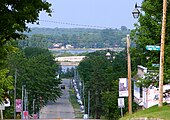
Port McNicoll 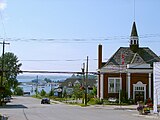
Victoria Harbour


Demographics[]
| 2016 | 2011 | |
|---|---|---|
| Population | 10,033 (+3.1% from 2011) | 9,736 (-0.1% from 2006) |
| Land area | 139.07 km2 (53.70 sq mi) | 139.00 km2 (53.67 sq mi) |
| Population density | 72.1/km2 (187/sq mi) | 70.0/km2 (181/sq mi) |
| Median age | 48.7 (M: 47.9, F: 49.4) | |
| Total private dwellings | 4,931 | 5,049 |
| Median household income | $65,190 |
Notable people[]
- Amos Arbour - NHL, NHA hockey player, member of original Montreal Canadiens hockey club.
- Wayne Middaugh - World Champion Curling Skip
- Sherry Middaugh - Canadian Curling Skip
- Keith Waples - Famed driver of Standardbred horses and inductee into Canada's Sports Hall of Fame
See also[]
References[]
- ^ "Tay census profile". 2011 Census of Population. Statistics Canada. Retrieved 2012-02-15.
- ^ "Census Profile, 2016 Census: Tay, Township". Statistics Canada. Retrieved July 3, 2019.
- ^ Rayburn, Alan (1997), Place Names of Ontario (University of Toronto Press), Toronto-Buffalo-London, ISBN 0-8020-7207-0), pp.345
- ^ "2016 Community Profiles". 2016 Canadian Census. Statistics Canada. August 12, 2021. Retrieved 2017-08-15.
- ^ "2011 Community Profiles". 2011 Canadian Census. Statistics Canada. March 21, 2019. Retrieved 2012-02-15.
- ^ "2006 Community Profiles". 2006 Canadian Census. Statistics Canada. August 20, 2019.
- ^ "2001 Community Profiles". 2001 Canadian Census. Statistics Canada. July 18, 2021.
External links[]
| Wikimedia Commons has media related to Tay, Ontario. |
Places adjacent to Tay, Ontario | |
|---|---|
- Lower-tier municipalities in Ontario
- Municipalities in Simcoe County
- Township municipalities in Ontario