Penrith, Cumbria
This article needs additional citations for verification. (December 2007) |
| Penrith | |
|---|---|
 The Market Square | |
 Flag | |
 Penrith Location in Eden, Cumbria | |
| Population | 15,181 (2011)[1] |
| OS grid reference | NY515305 |
| Civil parish |
|
| District |
|
| Shire county |
|
| Region | |
| Country | England |
| Sovereign state | United Kingdom |
| Post town | PENRITH |
| Postcode district | CA10, CA11 |
| Dialling code | 01768 |
| Police | Cumbria |
| Fire | Cumbria |
| Ambulance | North West |
| UK Parliament | |


Penrith (/pɛnˈrɪθ/ PEN-rith) is a market town and civil parish in the county of Cumbria, England, less than 3 miles (5 km) outside the Lake District National Park. It had a population of 15,181 at the 2011 Census.[1] Historically in Cumberland, Penrith's local authority is currently Eden District Council, which is based in the town, as were the defunct Penrith Urban and Rural District councils. From 1974 to 2015, it was an unparished area with no local council, but a civil parish was reintroduced as Penrith Town Council and first elected on 7 May 2015.

Toponymy[]

The etymology of the name has been debated. Several toponymists[4][5] argue for deriving it from the Cumbric or Welsh pen "head, chief, end" (both noun and adjective) + Cumbric rid, Welsh rhyd "ford". On this basis, the name would mean "chief ford", "hill ford", "ford end" or Whaley's suggestion: "the head of the ford" or "headland by the ford".[6]
Penrith, however, lies about 1 mile (1.6 km) from the nearest crossing of the River Eamont at Eamont Bridge. An alternative has been suggested consisting of the same pen element meaning "head, end, top" + the equivalent of Welsh rhudd "crimson".[7][8] Research on the medieval spelling variants of Penrith also suggests this alternative etymology.[9] The name "red hill" may refer to Beacon Hill, to the north-east of today's town. There is also a place called Redhills to the south-west, near the M6 motorway, and a place called Penruddock, about 6 miles (9.7 km) west of Penrith. These names all reflect the local geology, as red sandstone is abundantly available in this area and was used for many buildings in Penrith.
History[]
Romans[]
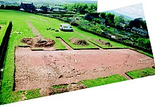
The Roman fort of Voreda occupied the site now known as Old Penrith, five miles north of the town.[10]
The Roman road from Manchester to Carlisle ran through the area.[11] Excavations before an extension to Penrith Cemetery showed the road had survived better at the edges of the field. The cobble and gravel surfaces seemed to have been ploughed out at the centre. The road was constructed by excavating a wide, shallow trench below subsoil level.[12] Large cobbles were probably obtained nearby, as they did not appear frequently in the subsoil in the excavated area. They were added to the excavated subsoil dumped back into the cut to form a stable foundation, canted at the centre of the road.
Local government[]
| Penrith Urban District | |
|---|---|
| History | |
| • Created | 1894 |
| • Abolished | 1974 |
| • Succeeded by | Eden District |
| Status | Urban district |
| • HQ | Penrith Town Hall |
Penrith was an urban district between 1894 and 1974, when it was merged into Eden District. Its area was coterminous with the civil parish of Penrith, although when the council was abolished Penrith became an unparished area. The area had been an urban sanitary district presided over by a Local Board of Health. The district also contained the hamlets of Carleton (now a suburb of Penrith), Bowscar, Plumpton Head and part of the village of Eamont Bridge. It was divided into four wards, North, South, East and West, which remained the basic local-government divisions in the town until the 1990s. In the 1920s Penrith Castle came into the council's possession. Its grounds became a public park, and Castle Hill or Tyne Close Housing Estate was built nearby. Further council housing was built at Fair Hill and Castletown before the Second World war, and after the war at Scaws, Townhead and Pategill. The district was bordered on three sides by Penrith Rural District; the southern boundary, marked by the River Eamont, was with Westmorland.
Governance[]
UK Parliament[]
Penrith is in the parliamentary constituency of Penrith and the Border. Neil Hudson was elected its Conservative Member of Parliament at the 2019 General Election, he gained a majority of 37.8 per cent, replacing Rory Stewart.
Local government[]
Penrith has three levels of local government – county, district and parish (town). For county purposes it is governed by Cumbria County Council, whose social services and education departments used to have area offices in the town.
Penrith is the seat of administration for Eden District Council, one of the largest districts by area in England and the most sparsely populated. It is based at offices in Penrith Town Hall and at the building now known as Mansion House, formerly Bishop Yards House.
A civil parish of Penrith was first formed in 1866. Between 1894 and 1974 the Urban District council acted as the parish council, but on its abolition, its successor authority, Eden District Council, decided that Penrith would become an unparished area under the district council's direct control. In 2014 a referendum was held open to all registered voters in the unparished area of Penrith to see if they wanted a parish council for Penrith, and the result was in favour. The first elections to this council were held on 7 May 2015. At first the town council was based in offices in St Andrews Place, but since 2017 it has moved to the former county council offices in Friargate.
Local government divisions[]
For the purposes of electing councillors to Eden District Council and to Penrith Town Council,[13] the civil parish of Penrith is divided into six wards:
- Penrith West: Castletown and parts of the town centre and Townhead
- Penrith North: part of the town centre, the New Streets, most of Townhead and the outlying settlements of Roundthorn, Bowscar and Plumpton Head
- Penrith South: Wetheriggs, Castle Hill, a small part of the town centre, part of Eamont Bridge and part of the Bridge Lane/Victoria Road area
- Penrith East: part of the town centre, Scaws, Carleton Parklands and Barco
- Penrith Carleton (formerly part of Penrith East): Carleton Village, High Carleton, Carleton Heights, Carleton Hall Gardens
- Penrith Pategill (formerly part of Penrith East): Pategill, Carleton Drive/Place, Tynefield Drive/Court and part of Eamont Bridge
Penrith West and South wards make up the Penrith West Electoral Division of Cumbria County Council, while East, Carleton and Pategill wards combine to form Penrith East division. Penrith North, along with the rural Lazonby ward, makes up Penrith North division.
Geography[]
| show Places adjacent to Penrith, Cumbria |
|---|
Watercourses[]
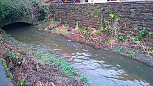
Penrith is located in the Eden Valley, just north of the River Eamont. Other local rivers bounding the town are the River Lowther and the River Petteril. Thacka Beck flows through the centre of the town in a partially man-made watercourse,[14] remaining mostly underground. It connects the River Petteril and the River Eamont. For many centuries, the Beck provided Penrith's main water supply. Thacka Beck Nature Reserve provides flood storage which protects homes and businesses in Penrith.[15][16] Another stream, known as The Myers or Dog Beck, flows through and under the southwestern area of the town, joining Thacka Beck near Tynefield Court. The Dog Beck section has also been referred to as Scumscaw Beck or Tyne Syke. In 2014 the pub chain Wetherspoons opened a branch in Penrith, naming it after the Dog Beck. There are also streams or becks running through the Carleton area of the town.
Divisions and suburbs[]
Castletown[]
Castletown is the area to the west of the West Coast Main Line railway line and includes the Gilwilly Industrial Estate and part of the Penrith or Myers Industrial Estate. The area – which was originally built to house workers on the railway line - mostly consists of late 19th- and early 20th-century (mainly terraced) housing, including some council housing. Since the 1990s, private developments such as Greystoke Park, Castletown Drive and Castle Park have sprung up.
There was until March 2010 a pub in the suburb, The Castle Inn, and in previous years there was a sub-post office, a Co-op store and other shops, all now closed. Until the 1970s, Castletown had its own church, St Saviour's in Brougham Street, which acted as a chapel of ease to Penrith's parish church of St Andrew and was originally built as a Primitive Methodist chapel. As of 2017, the Oasis Evangelical Church holds services at the Brackenber Court sheltered housing complex in Musgrave Street and The Church in the Barn Elim Pentecostal church has services at the community centre at Gilwilly.
The suburb has a community centre on the recreation ground at Gilwilly and until recently held an annual gala day and parade throughout Penrith. At one time in the mid-20th century elections were held amongst regulars at the Castle pub to find a Mayor of Castletown. There is longstanding rivalry between the Castletown and Townhead districts.
Townhead[]
Townhead is the general name for the northern area of the town, which includes the Fair Hill district and the Voreda Park or Anchor housing estate. The main part of area is built along both sides of the A6 road, heading up the hill in the direction of Carlisle. The road is street-named Stricklandgate and Scotland Road, but on maps dating before the mid-19th century was just marked as Town Head.
Town Head was one of the seven constablewicks into which the ancient parish of Penrith was divided. The others were Middlegate, Burrowgate, Dockray and Netherend within the town proper, and Plumpton Head and Carleton outside the town.
New Streets[]
This section does not cite any sources. (July 2012) |
New Streets is a name for the area between Townhead and Scaws on the side of the Beacon Hill (or Fell), which consists of steep streets of some terraced housing, but mainly large detached and semi-detached houses, mostly laid out in the late 19th century. The streets are, from north to south, Graham Street, Wordsworth Street, Lowther Street and Arthur Street. The term is sometimes extended to include Fell Lane, which is actually the ancient east road from Penrith town centre to Langwathby), and Croft Avenue and Croft Terrace (dating from about 1930), which were not developed till later. At the foot of the streets is Drovers Lane, formerly Back Lane, which is sub-divided in parts into Drovers Terrace, Wordsworth Terrace, Lowther Terrace, Bath Terrace, Arthur Terrace, Lonsdale Terrace and finally Meeting House Lane. Running along the top of the streets is Beacon Edge from which extensive views can be seen over the town and towards the Lake District. Until the turn of the 20th century, Beacon Edge was known as Beacon Road. Apart from the streets up the fellside there are some that connect smaller housing developments between them. The fellside is known to have been used as a burial ground for victims of the many plague attacks that struck Penrith down the centuries. There are also areas that still have farming names, such as a wooded enclosure in Fell Lane is still known as the Pinfold (or Pinny), once used to house stray animals until their owners paid to claim them. One lane off Beacon Edge is still known as 'Intack Lane' (i. e. the lane to farmed land). Most of the land that formed the intack itself was used to form Penrith Cemetery.
Scaws[]
The Scaws Estate was built by Penrith Urban District Council almost immediately after World War II on land hitherto known as the Flatt Field and Scaws Farm, which formed part of the Lowther Estates. Scaws Farm is now known as Coldsprings Farm. The name was changed after a murder that took place there. In later years some private housing was built on the higher parts of the estate. Beaconside Infants and Junior Schools are located in the centre of the estate and there were at one time three corner shops and a launderette in the area. Adjoining Scaws are the privately owned Barcohill and Meadow Croft housing estates.
Carleton[]
Carleton was once a separate settlement. Carleton Village itself is a small line of houses along one side of the A686 road, forming part of the boundary of the built-up area. Carleton Hall houses the headquarters of the Cumbria Constabulary.[17] The area of Carleton is the home of Carelton Banks FC, colloquially known as the Pinks.[18]
Pategill[]
Adjoining Carleton is the Pategill Housing Estate which started as a council estate on land once part of the Carleton Hall estate and still mostly owned by housing associations. Two streets on the estate, Prince Charles Close and Jubilee Close, were opened by the Prince of Wales in 1977. The centre of the estate is accessible by foot only and there was until 2012 a small convenience store. Several properties are run as sheltered housing for the elderly.
Wetheriggs[]
The Wetheriggs, Skirsgill and Castle Hill or Tyne Close areas were first developed in the 1920s by Penrith Urban District Council on land formerly known as Scumscaw. The first private housing was developed in Holme Riggs Avenue and Skirsgill Gardens just before World War II. Further development did not start until the 1960s and 1970s, on land between Wetheriggs Lane and Ullswater Road. Not until the late 1980s were the two roads were connected by the building of a Clifford Road extension which saw the Skirsgill area developed. Within the area are three schools: Ullswater Community College. North Lakes Junior and Queen Elizabeth Grammar School (QEGS). The Crescent on Clifford Road is a block of sheltered accommodation for the elderly. There was once a shop at the junction of Huntley Avenue and Clifford Road next to North Lakes School and another at the foot of Holme Riggs Avenue. The large North Lakes Hotel and Spa stands at the junction of Clifford and Ullswater Roads overlooking the Skirsgill Junction 40 Interchange of the M6 motorway, A66 and A592 roads.
Penrith New Squares[]
Plans to expand the town centre of Penrith southwards into the Southend Road area began to be implemented with the expansion of the swimming pool into a modern leisure centre complex. Hitherto the area had been a car park and sports fields, including ones used by Penrith and Penrith United football clubs. The plans for the rest of the scheme were developed by a property company and included a new Sainsbury's supermarket,[19]), new shopping streets, car parking and housing. The name Penrith New Squares refers to the new shops to be centred around two squares for parking and public entertainment.[20]
Work on the development was suspended in October 2008 for lack of funding in the financial crisis,[21] but a new deal was agreed with Sainsbury's and work resumed in 2011. This updated scheme includes less new housing and parts of the scheme were deferred for up to five years.[22] Sainsburys opened in December 2011. In June 2013, the first shop in the squares opened together with a walk through from Sainsburys to the town centre.
Climate[]
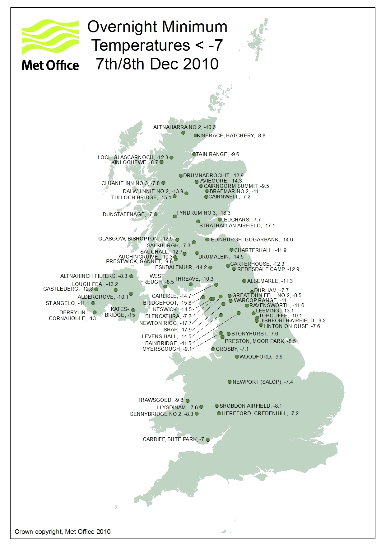
As with most of the British Isles, Penrith experiences a maritime climate with warm summers and cool winters. The nearest Met Office weather station is at Newton Rigg, about a mile outside of the town centre. Temperature extremes range from 33.3 °C (91.9 °F) during July 1901,[23] down to −17.8 °C (0.0 °F) in February 1969,[24] although this was nearly exceeded by a temperature of −17.7 °C (0.1 °F) in December 2010.[25] Newton Rigg also holds the record for the coldest April temperature reported in England, −15.0 °C (5.0 °F) during April 1917.[26]
| hide | |||||||||||||
|---|---|---|---|---|---|---|---|---|---|---|---|---|---|
| Month | Jan | Feb | Mar | Apr | May | Jun | Jul | Aug | Sep | Oct | Nov | Dec | Year |
| Record high °C (°F) | 12.8 (55.0) |
14.4 (57.9) |
20.6 (69.1) |
24.6 (76.3) |
26.9 (80.4) |
29.1 (84.4) |
29.5 (85.1) |
31.1 (88.0) |
26.7 (80.1) |
21.7 (71.1) |
16.7 (62.1) |
15.0 (59.0) |
31.1 (88.0) |
| Average high °C (°F) | 6.1 (43.0) |
6.6 (43.9) |
8.8 (47.8) |
11.6 (52.9) |
15.1 (59.2) |
17.4 (63.3) |
19.5 (67.1) |
19.0 (66.2) |
16.3 (61.3) |
12.5 (54.5) |
8.8 (47.8) |
6.4 (43.5) |
12.4 (54.3) |
| Daily mean °C (°F) | 3.4 (38.1) |
3.6 (38.5) |
5.4 (41.7) |
7.4 (45.3) |
10.4 (50.7) |
13.0 (55.4) |
15.1 (59.2) |
14.6 (58.3) |
12.3 (54.1) |
9.1 (48.4) |
5.9 (42.6) |
3.4 (38.1) |
8.6 (47.5) |
| Average low °C (°F) | 0.6 (33.1) |
0.6 (33.1) |
2.0 (35.6) |
3.2 (37.8) |
5.7 (42.3) |
8.6 (47.5) |
10.7 (51.3) |
10.2 (50.4) |
8.2 (46.8) |
5.7 (42.3) |
2.9 (37.2) |
0.4 (32.7) |
4.9 (40.8) |
| Record low °C (°F) | −16.7 (1.9) |
−17.8 (0.0) |
−13.9 (7.0) |
−7.2 (19.0) |
−4.4 (24.1) |
−0.3 (31.5) |
1.1 (34.0) |
0.6 (33.1) |
−2.2 (28.0) |
−6.0 (21.2) |
−12.6 (9.3) |
−17.7 (0.1) |
−17.8 (0.0) |
| Average precipitation mm (inches) | 101.5 (4.00) |
74.3 (2.93) |
75.8 (2.98) |
52.2 (2.06) |
56.1 (2.21) |
58.6 (2.31) |
70.2 (2.76) |
70.1 (2.76) |
76.3 (3.00) |
106.9 (4.21) |
100.1 (3.94) |
105.0 (4.13) |
947.0 (37.28) |
| Average precipitation days (≥ 1.0 mm) | 15.1 | 11.2 | 13.1 | 10.8 | 10.6 | 10.4 | 11.1 | 11.5 | 11.6 | 15.3 | 15.3 | 14.4 | 150.4 |
| Mean monthly sunshine hours | 38.8 | 59.0 | 97.0 | 135.4 | 166.9 | 161.7 | 160.1 | 145.5 | 114.6 | 79.4 | 41.7 | 37.2 | 1,237.3 |
| Source 1: Met Office[27] | |||||||||||||
| Source 2: KNMI[28] | |||||||||||||
Landmarks[]

The main church is St Andrew's built in 1720–1722 in an imposing Grecian style, abutting a 13th-century tower. The churchyard has ancient crosses and hogback tombstones known as the "Giant's Grave" (early 10th century) and "Giant's Thumb" – remains of a Norse cross from about 920.[29]
The ruins of Penrith Castle (14th–16th centuries) can be seen from the adjacent railway station. It is run as a visitor attraction by English Heritage. To the south-east of the town are the more substantial ruins of Brougham Castle, also protected by English Heritage, as are the ancient henge sites known as Mayburgh Henge and King Arthur's Round Table to the south.

In the centre of the town is the Clock Tower erected in 1861 to commemorate Philip Musgrave of Edenhall. Hutton Hall in Friargate has a 14th-century pele tower at the rear, attached to an 18th-century building. Dockray Hall (once the Gloucester Arms) is dated to about 1470 and may include remains of another pele tower.[30] Richard, Duke of Gloucester resided here before becoming King Richard III and carried out extensive work at Penrith Castle about 1471.
Penrith has been noted for the number of wells in and around the town. well-dressing ceremonies were commonplace on certain days in May. Three miles south-east of the town, on the River Eamont opposite Ninekirks, are the "Giants' Caves", where the well was dedicated to St Ninian. The caves are enlarged out of Lower Permian sandstones and their associated breccias and purple shales.
Just to the north of the town is the wooded signal-beacon hill named , but originally Penrith Fell. Its last use was probably in 1804 in the war against Napoleon. Traditionally, the Beacon Pike was used to warn of approaching danger from Scotland. Today, though surrounded by commercial woodland owned by Lowther Estates, the hill still has some natural woodlands and is visited by locals and tourists. On a clear day most of the Eden Valley, the local fells, Pennines and parts of the North Lakes can be seen. Beacon Hill may have given Penrith its Celtic name of "red hill".
A fibreglass 550 cm (18 ft)-tall statue of King Kong once stood in the Skirsgill Auction Mart.[31]

Transport[]
Just off Junction 40 of the M6 motorway, the A66, A6 and A686 intersect in the town.
Penrith is a stop on the West Coast Main Line, with the station (dating from 1846) officially known as Penrith North Lakes. Since an upgrade to the West Coast Main Line was completed in 2008, fewer trains have stopped at Penrith, leaving only an irregular service to London, Birmingham, Manchester, Glasgow and Edinburgh.
National Express operate two long-distance coach routes with stops in Penrith.
The National Cycle Network's major National Route 7 runs through the town, and National Route 71 stops just short of its southern edge.
Penrith has a number of taxi firms licensed by Eden District Council. The main taxi rank is in Sandgate in the middle of town, near the bus station, and there is another outside the railway station.
Local buses are run mostly by Stagecoach in Cumbria, with frequent links to Carlisle, Keswick and West Cumbria, Ullswater and less frequent ones to Windermere, Appleby-in-Westmorland and Kendal. There is also a 646 town service, run by local firm NBM Motors, which serves most of the town once an hour. Fellrunner buses connect Penrith to villages in the Eden Valley. A daily service to Alston and Newcastle-upon-Tyne is run by Wright Brothers of Nenthead.
The bus station is in the town centre off Sandgate. Many services also stop at the railway station.
Public services[]

Health[]
Penrith Hospital and Health Centre is situated along Bridge Lane at the southern entrance to the town close to the Kemplay Bank roundabout, where the A6, A66 and A686 meet. These are administered by the Cumbria Partnership NHS Trust.
The hospital was opened in 1970 to replace the Jubilee Cottage Hospital on Beacon Edge, Fairhill Fever Hospital, and the maternity home at the former workhouse in Castletown. The hospital comprises wards for the elderly and mental health care, a minor injuries and Primary Care Assessment unit, a small maternity wing and the Lady Anne Clifford Day Hospital. Various weekly clinics are held at the hospital and the health centre alongside, which opened in 1983 and brought all three of Penrith's NHS medical practices into one building (two have since merged). There is also a pharmacy within the centre.
There are several private and National Health Service dental practices in the town.
Police and fire service[]
Penrith falls comes under Cumbria Constabulary, whose headquarters are at Carleton Hall on the outskirts of the town. The town's own police station used to be located in Hunter Lane, but it has since been replaced by a smaller facility close to Carleton Hall.
Carleton Hall is also the location of Penrith's fire station and the headquarters of Cumbria Fire and Rescue Service.
Ambulance services[]
The North West Ambulance Service has a base in Tynefield Drive, close to the hospital. The Great North Air Ambulance Service has its Cumbrian base close to Penrith at Langwathby and was at one time-based at Carleton Hall. The Penrith Mountain Rescue team whose operating area covers the Eden Valley, North Pennines and the area towards the Scottish border also has a base in Tynefield Drive.
Notable people[]
In order of birth:
- Richard III (1452–1485) lived at Penrith Castle for a time. The links to him in the town include two fragments of medieval glass. One in St Andrew's Church is taken to show the heads of Richard Plantagenet and Cecily Neville – Richard III's parents. The other, on display in the town, shows the Musgrave coat of arms. Richard III is thought to have stayed at the Gloucester Arms, then a large private house. The bar has panelling of various periods, behind which is an early screen carved with a design taken to be broom (Planta genista), an emblem of the Plantagenet kings.
- The Scottish road-builder and engineer John Loudon Macadam (1756–1836), inventor of macadamized roads, lived for a while at Cockell House in Townhead. Close by are streets named Macadam Way and Macadam Gardens.
- George Leo Haydock (1774–1849), noted for an annotated edition of the Catholic Douay Bible, served as Catholic priest here from 1839 until his death in 1849.
- Penrith was the home town of the mother of the poet William Wordsworth (1770–1850). He spent some of his childhood there, attending school with Mary Hutchinson, his later wife.
- The Victorian writer Frances Trollope (1779–1863), Anthony Trollope's mother, lived for a while at a house called Carleton Hill (not Carleton Hall) outside the town on the Alston road.
- Samuel Plimsoll (1824–1898), MP and social reformer, spent some of his childhood at Page Hall in Foster Street. The houses at Townhead called Plimsoll Close are named after him.
- Percy Toplis (1896–1920), the "monocled mutineer", was shot and killed on the run by police at Plumpton, near Penrith. He is buried in Penrith's Beacon Edge Cemetery in an unmarked grave. His monocle is on display in Penrith and Eden Museum.
- Mary (1916–2018), wife of Prime Minister Harold Wilson, lived in Penrith whilst her father was minister at the Congregational Church in Duke Street.
- Stuart Lancaster (born 1969) became head coach of the England national rugby union.
- Paul Nixon (born 1970), Leicestershire wicket-keeper and England cricket international, was born in Carlisle, but grew up in the Penrith area. Nixon retired from professional sport in 2011.
- Angela Lonsdale (born 1970 in Penrith), actress, is perhaps best known as policewoman Emma Taylor in Coronation Street and currently stars as DI Eva Moore in the BBC soap Doctors.
- Charlie Hunnam (born 1980), the actor, attended Queen Elizabeth Grammar School, Penrith (QEGS) and lived locally in his teenage years. He claimed it is "just about the worst place you could hope to live".[32]
- Lewis Brett Guy (born 1985 in Penrith) is an English football forward currently with Annan Athletic F.C.
- Danny Grainger (born 1986), footballer, scored Heart of Midlothian's third goal in the 2012 Scottish Cup final against Hibernian.
- Oliver Turvey (born 1987), racing driver, attended Queen Elizabeth Grammar School and lives locally.
- Stephen Hindmarch (born 1989), a professional footballer, was born here.
Night life[]
Like other rural towns of its size, Penrith relies on public houses to form the basis of social entertainment, and was once famous for the sheer number of pubs in the town, served by five working breweries. The trend of pub closures is still continuing, but a considerable number remain. They range from small traditional pubs with a loyal clientele to bigger bars that form part of the "circuit". Penrith also has numerous dining places and restaurants.
The Lonsdale (formerly the Alhambra) in Middlegate is a cinema with three screens built in 1910 by William Forrester. There was until the 1980s another cinema called the Regent on Old London Road.
Amateur dramatics and musicals are staged at the Penrith Players Theatre, Ullswater Community College and Queen Elizabeth Grammar School.
Penrith dialect[]
The Penrith dialect known as Penrithian, spoken around the Penrith and Eden district area, is a variant of the Cumbrian dialect.
Media[]
The local newspaper, the Cumberland and Westmorland Herald appears on Saturdays. Sections are updated every following Tuesday on their website. It is independently owned, with offices on King Street, but printed at the Newsquest's printing works in Glasgow, along with the weekly and daily News and Star which also cover some news items from Penrith. A separate edition of the Herald is published for the Keswick area, known as the Lake District Herald.
Penrith lies with the ITV Border region and the BBC's North East and Cumbria region. There are three local radio stations serving the Penrith area. Eden FM which is based in Penrith and two others based in Carlisle. These are BBC Radio Cumbria and the independent station CFM.
Penrith was used as a setting in the 1940 book Cue for Treason by Geoffrey Trease. It was also a setting for Bruce Robinson's 1987 film Withnail and I, although the Penrith scenes were actually filmed in Stony Stratford, Buckinghamshire.[33]
Education[]
Uniformed youth organisations[]
Penrith is home to two Community Cadet Forces units:
- 1247 Squadron of the Air Training Corps
- Penrith Detachment of Cumbria Army Cadet Force
Primary schools[]
- Brunswick School (formerly County Infants), Brunswick Road
- Beaconside Primary, Eden Mount/Brent Road (until 2008 there were separate Beaconside Infant and Junior schools)
- North Lakes School (formerly Wetheriggs Junior; was at first a girls-only school), Huntley Avenue – North Lakes was one of the first schools in England to be awarded a Sing Up Gold Award (in December 2008) and their highest accolade, a Sing Up] Platinum Award (likewise in December 2008).
- St Catherines Roman Catholic Primary, Drovers Lane
- Hunter Hall (independent preparatory school), Frenchfield
Secondary schools[]
- Ullswater Community College (formerly Ullswater High School, and before that, two single sex secondary modern schools on the same site called Tynefield (girls) and Ullswater (boys)), Wetheriggs Lane
- Queen Elizabeth Grammar School (QEGS) (selective), Ullswater Road
Further education[]
- The Yorkshire agricultural college Askham Bryan College has a campus just outside the town, formerly Newton Rigg College. The University of Cumbria has a centre for Conservation, Forestry, Outdoor Studies and Policing based on the same campus.
- Ullswater Community College had a large further or adult education centre.
Former schools in the town include:
- Girls National School (building now housing school replaced by Beaconside Juniors), Drovers Lane
- Boys National School or St Andrews School for Boys (building now demolished school replaced by Beaconside Juniors), Benson Row
- National Infants School (now Penrith Playgroup Nursery School), Meeting House Lane
- Robinsons School – this was a girls-only school founded with 29 pupils, which later became a mixed (infant) school founded in 1670 by William Robinson, a local merchant who made good in London. It now houses the town's museum and tourist information centre, Middlegate, and has the following inscription above the door: "Ex sumptibus DN Wil Robinson civis Lond anno 1670 DN"
- County Girls School (building now part of Brunswick Infants, the school was replaced by Wetheriggs), Brunswick Road
- County Boys School (the building now QEGS Sixth Form Centre, also for a while an annexe to Wetheriggs). The school merged with Wetheriggs Girls to form Wetheriggs Junior, Ullswater Road
- Tynefield Secondary Modern (originally co-educational but later girls only), Wetheriggs Lane
- Ullswater Secondary Modern (boys only), Wetheriggs Lane. Ullswater and Tynefield schools and buildings merged to create Ullswater High in 1980.
Churches[]
Church of England[]

- St Andrew's Church is the ancient parish church of Penrith Parish, sited in the centre of Penrith. It is the largest of four parishes making up the Penrith Team Ministry.
- Christ Church, Drovers Lane/Stricklandgate, opened in 1850 as a separate parish, but from 1968 to 2008 was part of the United Parish of Penrith. It is now again a separate parish church for the northern part of the town, remaining within the Penrith Team Ministry.
Roman Catholic Church[]
- St Catherine's, Drovers Lane
Methodist Church of Great Britain[]
- Penrith Methodist Church, Wordsworth Street
Others[]
- United Reformed Church, Lowther Street
- Society of Friends, Quaker Meeting House, Meeting House Lane
- Gospel Hall Evangelical Church, Albert Street/Queen Street
- King's Church Eden - part of the Newfrontiers family of churches
- Oasis Evangelical Church, Brackenber Court, Musgrave Street
- Salvation Army, Hunter Lane
- Church in the Barn, Castietown Community Centre, Gilwilly
- Influence Church Assemblies of God, Burrowgate
Economy[]

As a small market town relying quite heavily on the tourist trade, Penrith benefits from a mix of some high street chain stores and many small local specialist shops. However, many shops have given way to businesses such as banks, building societies and travel agents.
Market days are traditionally Tuesday and Saturday. On Tuesdays there was a small outdoor market in Great Dockray and Cornmarket. This ceased in the early 21st century, since when a small farmers' market has been held in the Market Square once a month. On Saturdays, Cumbria's largest outdoor market takes place at the Auction Mart alongside the M6 motorway junction 40.
The main shopping areas in the town centre are Middlegate, Little Dockray, Devonshire Street/Market Square, Cornmarket, King Street, Angel Lane and the Devonshire Arcade and Angel Square precincts with some shops in Burrowgate, Brunswick Road and Great Dockray.
Although the main industries in the area are based around tourism and agriculture there are some other industries represented in Penrith. For example, in 2011 Greggs opened a new bakery at Gilwilly, replacing two bakeries in the Friargate area that used to belong to the Penrith-based Birketts firm. Domino's Pizza had a dough manufacturing site at Gilwilly until 2019. The model firm Lilliput Lane (now part of Enesco) was founded in Penrith and until March 2009 had its main factory at Skirsgill Park. Also at Penrith Industrial Estate is the Penrith Door Company factory, formerly part of Magnet Joinery, now of the American-based JELD-WEN group.
Agriculture-based industries include BOCM Pauls, which has a large animal feed mill on the Penrith Industrial Estate. Until 2005 there was another feed mill at Gilwilly, originally belonging to Cumberland and Westmorland Farmers Ltd, but eventually becoming part of the Carrs Milling Industries group. Local butchers Cranstons have an expanding meat packing, pie and sandwich-manufacturing site alongside their shop and head office on Ullswater Road.
Penrith was known for its tanning industry and breweries. The tanneries were mainly in the Friargate/Old London Road area of the town. There were at one time five working breweries. Penrith in recent years has attracted many larger international haulage firms to open depots beside the M6.
Fylde Guitars is a manufacturer of hand-made fretted musical instruments, founded in Penrith in 1973 by luthier Roger Bucknall. Its instruments command high prices. All are hand-made using traditional techniques and have been developed in collaboration with professional players. Fylde Guitars is the only UK guitar maker to have been awarded the Acoustic Guitar Magazine "Gold Award", in 2000.
Sport[]
Penrith is home to Penrith Rugby Union Football Club, which currently plays in the RFU National League 3 North. Home games are played at Winters Park in Penrith.
Penrith A.F.C. plays in the Northern Football League.
Penrith also has a skate park area by the Penrith Leisure Centre. The skate park opened in 2007.[34]
Penrith has a golf club and driving range. Penrith Castle Park houses the town's Bowling Club.
was founded in 1881 and was then based at Frenchfield in the River Eamont. Training sessions originally involved great variations of conditions that challenged the skills of any swimmer. Icy water, strong currents and obstacles like weed and the odd eel or two provided the ultimate test of stamina. It was all a far cry from conditions for today's training sessions, held at Penrith Leisure Centre.[35]
Penrith Canoe Club, founded in 2012, trains at the local leisure centre. Its main activity is canoe polo, in which the club was represented at the World Championships in Syracuse, Italy 2016 by its under-21 women's squad, which finished a respectable fourth.
Penrith Tennis Club is located in the grounds of Penrith Rugby Club at Carleton Village.
Twin town[]
Since 1989 Penrith has had a twinning arrangement with the Australian city named after it in New South Wales.[36]
Regular events[]
- Mayday Carnival
- On the first Monday in May, Penrith holds a Mayday Carnival run by Penrith Lions Club. It includes a parade, street dancers and fairground rides in the Great Dockray and Market Square car parks of the commercial area. The procession includes floats, vintage cars and tractors, a marching band, various local celebrities and members of the Penrith Lions Club. It starts in the yard of Ullswater Community College and ends in the bus station car park. Many roads in the centre are closed for the event.[37]
- Penrith Agricultural Show
- The first Penrith Show was held in 1834. From 2019 the event takes place on the 3rd Saturday in July.[38]
- The Winter Droving
- Held in late October/early November 'The Winter Droving Festival' celebrates all things rural, traditional and fun. The highlight is a torch-lit procession through the town, featuring fire, lanterns, masquerade and music and mayhem. The event is a celebration of Penrith and its age-old role as the market place for the local area, where for centuries livestock and produce has been brought for sale.[39]
- Kendal Calling
- Music Festival held in late July each year at Lowther Deer Park has had headline acts that included the Stereophonics, Tinie Tempah, Editors and the Manic Street Preachers.[40]
- Potfest
- Ceramic Festivals takes place as Potfest in the Pens and Potfest in the Park at Skirsgill Auction Mart and Hutton in the Forest.
- Lowther Show
- Held at nearby Lowther Castle each August, this includes the Lowther Horse Driving Trials as attended in the past by Prince Philip.[41]
See also[]
- Listed buildings in Penrith, Cumbria
- Cockermouth, Keswick and Penrith Railway
- Penrith and The Border (UK Parliament constituency)
- Penrith Mountain Rescue Team
- Penrith Hoard
References[]
Latitude/Longitude sourced from OpenStreetMap
- ^ Jump up to: a b UK Census (2011). "Local Area Report – Penrith Built-up area (E34000039)". Nomis. Office for National Statistics. Retrieved 18 April 2021.
- ^ [1]
- ^ Gilpin, William (1786), Observations relative chiefly to Picturesque Beauty, Made in the year 1772.... Cumberland & Westmoreland. R. Blamire, London. Facing p. 85.
- ^ Ekwall, E (1947). The Concise Oxford Dictionary of English Place Names. Oxford, UK: OUP. p. 345.
- ^ Mills, A. D. (1991). Dictionary of British Place Names. Oxford, UK: Oxford University Press. p. 366. ISBN 0-19-852758-6.
- ^ Whaley, Diana (2006). A dictionary of Lake District place-names. Nottingham: English Place-Name Society. pp. lx, 423 p. 263. ISBN 0904889726.
- ^ Williamson, W. A. (1849). Local Etymology; or names of places in the British Isles, and in other parts of the world. p. 92.
- ^ Lee, Joan (1998). Place Names of Cumbria. Carlisle, UK: Heritage Services. p. 65. ISBN 0-905404-70-X.
- ^ Tino Oudesluijs (2020). "Revisiting some problematic British-Celtic place names in Northwest England". in "Kelten. Mededelingen van de Stichting A. G. van Hamel voor Keltische Studies".
- ^ Roman Britain. "Voreda". Archived 8 October 2014 at the Wayback Machine
- ^ Cumbria SMR no. 11055: Site of Roman road.
- ^ R. G. Collingwood and I. Richmond, The Archaeology of Roman Britain London, Methuen, 1969.
- ^ "Penrith Town Council".
- ^ Taylor, Karl (2010). "Thacka Beck Flood Alleviation Scheme, Penrith, Cumbria- Measured Building Survey of Culverts". Oxford Archaeology North.
- ^ It is part of ALFA (Adaptive Land Use for Flood Alleviation). Eden Archived 22 December 2015 at the Wayback Machine, ALFA
- ^ "Thacka Beck". Archived from the original on 29 December 2013. Retrieved 1 September 2013.
- ^ "Carleton Hall (Cumbria Police Headquarters)". Historic England. Retrieved 23 October 2020.
- ^ France, Ben; Jackson, Liam (18 September 2015). "Ambleside United Sink The Pinks". Retrieved 23 October 2020.
- ^ "Council rejects Tesco's millions in Penrith supermarket deal". Cumberland and Westmorland Herald. 29 December 2001. Retrieved 11 November 2017.
- ^ "New Homes in Penrith - Living at Penrith New Squares". Archived from the original on 21 November 2008.
- ^ Cumberland News 10 Oct 2008 Archived 13 October 2008 at the Wayback Machine
- ^ Eden District Council Press Releases Archived 9 January 2011 at the Wayback Machine
- ^ "1900 record". Trevor Harley. April 2020.
- ^ "1969 temperature". KNMI.
- ^ "2010 temperature". UKMO.
- ^ "1917 temperature". UKMO. Archived from the original on 6 February 2012.
- ^ "Newton Rigg 1981–2010 averages". Met Office. Archived from the original on 31 October 2012. Retrieved 11 August 2020.
- ^ "Indices Data – Newton Rigg STAID 1804". KNMI. Retrieved 11 August 2020.
- ^ "PENRITH, Cumberland-Church history". GENUK. Retrieved 9 December 2010.
- ^ Historic England. "Dockray Hall (12326)". Research records (formerly PastScape). Retrieved 4 June 2011.
- ^ "King Kong sculpture soon to tower over Cumbrian Saturday market". . 28 January 2011. Archived from the original on 24 March 2012. Retrieved 22 August 2011.
- ^ "Actor claims Penrith is "just about worst place you could hope to live"". cwherald.com. Retrieved 17 March 2017.
- ^ Scovell, Adam (11 April 2017). "In search of the Withnail & I locations 30 years on". British Film Institute. Retrieved 14 March 2019.
- ^ "Penrith Skate Park". Retrieved 24 March 2015.
- ^ "Penrith Swimming Club". penrithswimmingclub.co.uk. Retrieved 19 February 2016.
- ^ Sister city arrangements for Penrith Archived 12 June 2007 at the Wayback Machine
- ^ Photographs etc. Retrieved 26 August 2021.
- ^ "Downpours didn't dampen spirits at Penrith Show". News and Star. 22 July 2017.
- ^ Irving, Jonny (28 October 2017). "Winter Droving set to bring colourful end to Cumbria's summer". News and Star.
- ^ Binns, Simon (31 July 2017). "Kendal Calling 2017 in pictures – Stereophonics, Tinie Tempah, Editors, Manic Street Preachers and more". Manchester Evening News.
- ^ "Lowther Show given royal seal of approval by Prince Philip". News and Star. 11 August 2014. Archived from the original on 7 November 2017.
Further reading[]
- "Ewanion". History of Penrith. Carlisle, 1993. ISBN 0-9519920-3-1.
- Mullett, Michael A. (2017a). A New history of Penrith: book I: from pre-history to the close of the Middle Ages. Carlisle: Bookcase. pp. iv, 172 pp. ISBN 9781901414998.
- Mullett, Michael A. (2017b). A New history of Penrith: book II: Penrith under the Tudors. Carlisle: Bookcase. pp. 1–164. ISBN 9781912181049.
- Mullett, Michael A. (2018). A New history of Penrith: book III: Penrith in the Stuart century, 1603–1714. Carlisle: Bookcase. pp. 1–193. ISBN 9781912181100.
- Mullett, Michael A. (2019). A New history of Penrith: book IV: Penrith in the eighteenth century, 1715-1800. Carlisle: Bookcase. pp. 1–297. ISBN 9781912181209.
- Mullett, Michael A. (2020). A New history of Penrith: book V: Penrith in the nineteenth century, 1800-1901: chapters on the Victorian town. Carlisle: Bookcase. pp. 1–402. ISBN 9781912181346.
- Stringer, Keith J. (2019). The Kings of Scots, the liberty of Penrith, and the making of Britain (1237-1296). Tract series no.28. Kendal: Cumberland and Westmorland Antiquarian and Archaeological Society. ISBN 9781873124802.
External links[]
| Wikimedia Commons has media related to Penrith, Cumbria. |
| Wikivoyage has a travel guide for Penrith. |
- Cumbria County History Trust: Penrith (nb: provisional research only - see Talk page)
- Area profile based on 2001 Census Details
| show Authority control |
|---|
- Penrith, Cumbria
- Market towns in Cumbria
- Cumberland
- Towns in Cumbria
- Eden District
- Civil parishes in Cumbria