Peristera
Native name: Περιστέρα | |
|---|---|
 | |
 Peristera | |
| Geography | |
| Coordinates | 39°11′N 23°58′E / 39.18°N 23.97°ECoordinates: 39°11′N 23°58′E / 39.18°N 23.97°E |
| Archipelago | Sporades |
| Total islands | 2 |
| Highest elevation | 250 m (820 ft) |
| Highest point | Mt. Stefani |
| Administration | |
Greece | |
| Region | Thessaly |
| Regional unit | Sporades |
| Municipality | Alonnisos |
| Demographics | |
| Population | 30 (2011) |
| Additional information | |
| Postal code | 37005 |
| Area code(s) | 24240 |
| Vehicle registration | BO |

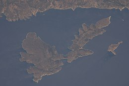
Peristera (Greek: Περιστέρα, feminine form of pigeon), also Aspro, locally Xero (meaning dry), Eudemia in antiquity,[1] is a Greek island in the Sporades. It is administratively part of the municipality of Alonnisos and is also directly east of the namesake island. As of 2011, the resident population of the island was 30.[2] Peristera is in Zone B of the Alonnisos Marine Park.
Nearest islands and islets[]
Its nearest islands and islets are Alonnisos to the north and west and Adelfoi Islets to the west.
References[]
- ^ Lund University. Digital Atlas of the Roman Empire.
- ^ "Detailed census results 2011" (xls 2,7 MB) (in Greek). National Statistical Service of Greece.
External links[]
- Peristera on GTP Travel Pages (in English and Greek)
- Official website of Municipality of Alonnisos (in Greek)

This Thessaly location article is a stub. You can help Wikipedia by . |
Categories:
- Landforms of the Sporades
- Islands of Thessaly
- Thessaly geography stubs