Perry County, New South Wales

From Wikipedia, the free encyclopedia

Map all coordinates using: OpenStreetMap 
Download coordinates as: KML
Perry
New South Wales
Perry NSW.PNG
Location in New South Wales
Lands administrative divisions around Perry:
Menindee Livingstone Manara
Windeyer Perry Manara
Wentworth Wentworth Kilfera

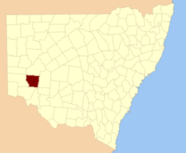
Perry County is one of the 141 Cadastral divisions of New South Wales. It is located to the east of the Darling River near Pooncarie.

Perry County was named in honour of Samuel Augustus Perry (1792–1854), soldier and surveyor.[1]

Parishes within this county[]

A full list of parishes found within this county; their current LGA and mapping coordinates to the approximate centre of each location is as follows:

Parish LGA Coordinates
Central Darling Shire 32°50′25″S 142°45′54″E / 32.84028°S 142.76500°E / -32.84028; 142.76500 (Astolat)
Wentworth Shire 33°06′55″S 142°21′41″E / 33.11528°S 142.36139°E / -33.11528; 142.36139 (Barrara)
Wentworth Shire 32°57′37″S 142°27′15″E / 32.96028°S 142.45417°E / -32.96028; 142.45417 (Barritt)
Wentworth Shire 33°19′27″S 143°14′44″E / 33.32417°S 143.24556°E / -33.32417; 143.24556 (Beela)
Wentworth Shire 33°28′58″S 142°42′15″E / 33.48278°S 142.70417°E / -33.48278; 142.70417 (Bell)
Wentworth Shire 33°25′44″S 143°09′07″E / 33.42889°S 143.15194°E / -33.42889; 143.15194 (Bertram)
Wentworth Shire 32°56′49″S 142°59′21″E / 32.94694°S 142.98917°E / -32.94694; 142.98917 (Bimpia)
Wentworth Shire 32°55′41″S 143°16′39″E / 32.92806°S 143.27750°E / -32.92806; 143.27750 (Blenalben)
Wentworth Shire 33°05′17″S 142°44′22″E / 33.08806°S 142.73944°E / -33.08806; 142.73944 (Burke)
Wentworth Shire 33°00′35″S 143°05′11″E / 33.00972°S 143.08639°E / -33.00972; 143.08639 (Camelot)
Coonong Wentworth Shire 33°00′12″S 143°10′53″E / 33.00333°S 143.18139°E / -33.00333; 143.18139 (Coonong)
Wentworth Shire 32°54′47″S 142°51′50″E / 32.91306°S 142.86389°E / -32.91306; 142.86389 (Cooyarunda)
Wentworth Shire 33°20′54″S 142°36′45″E / 33.34833°S 142.61250°E / -33.34833; 142.61250 (Darchy)
Wentworth Shire 33°03′42″S 142°58′23″E / 33.06167°S 142.97306°E / -33.06167; 142.97306 (Enid)
Wentworth Shire 33°20′44″S 142°43′33″E / 33.34556°S 142.72583°E / -33.34556; 142.72583 (Euchla)
Wentworth Shire 33°32′15″S 143°08′07″E / 33.53750°S 143.13528°E / -33.53750; 143.13528 (Garnpung)
Wentworth Shire 33°03′52″S 142°22′56″E / 33.06444°S 142.38222°E / -33.06444; 142.38222 (Glenstal)
Wentworth Shire 33°07′24″S 143°04′14″E / 33.12333°S 143.07056°E / -33.12333; 143.07056 (Gray)
Wentworth Shire 32°53′06″S 142°44′47″E / 32.88500°S 142.74639°E / -32.88500; 142.74639 (Gunpanoola)
Wentworth Shire 33°15′25″S 142°37′09″E / 33.25694°S 142.61917°E / -33.25694; 142.61917 (Harley)
Wentworth Shire 33°12′07″S 142°43′40″E / 33.20194°S 142.72778°E / -33.20194; 142.72778 (Howitt)
Wentworth Shire 33°11′43″S 143°17′34″E / 33.19528°S 143.29278°E / -33.19528; 143.29278 (Kandra)
Wentworth Shire 32°53′33″S 143°06′10″E / 32.89250°S 143.10278°E / -32.89250; 143.10278 (Karpakora)
Wentworth Shire 33°10′27″S 142°57′25″E / 33.17417°S 142.95694°E / -33.17417; 142.95694 (King)
Wentworth Shire 33°17′27″S 142°56′26″E / 33.29083°S 142.94056°E / -33.29083; 142.94056 (Mapenny)
Wentworth Shire 33°00′59″S 143°21′13″E / 33.01639°S 143.35361°E / -33.01639; 143.35361 (Midgehope)
Wentworth Shire 33°27′07″S 142°55′02″E / 33.45194°S 142.91722°E / -33.45194; 142.91722 (Mitchell)
Wentworth Shire 33°01′58″S 142°44′48″E / 33.03278°S 142.74667°E / -33.03278; 142.74667 (Mooloolerie)
Wentworth Shire 33°10′29″S 142°21′17″E / 33.17472°S 142.35472°E / -33.17472; 142.35472 (Moorara)
Wentworth Shire 33°11′48″S 143°09′46″E / 33.19667°S 143.16278°E / -33.19667; 143.16278 (Morthong)
Wentworth Shire 33°24′13″S 142°55′28″E / 33.40361°S 142.92444°E / -33.40361; 142.92444 (Mueller)
Wentworth Shire 33°23′01″S 142°49′15″E / 33.38361°S 142.82083°E / -33.38361; 142.82083 (Mungo)
Wentworth Shire 33°08′35″S 142°28′43″E / 33.14306°S 142.47861°E / -33.14306; 142.47861 (Mythe)
Wentworth Shire 33°14′14″S 143°03′14″E / 33.23722°S 143.05389°E / -33.23722; 143.05389 (Nambucurra)
Wentworth Shire 33°03′40″S 142°36′26″E / 33.06111°S 142.60722°E / -33.06111; 142.60722 (Nanda)
Wentworth Shire 33°21′13″S 143°02′12″E / 33.35361°S 143.03667°E / -33.35361; 143.03667 (Nania)
Wentworth Shire 33°11′08″S 142°32′35″E / 33.18556°S 142.54306°E / -33.18556; 142.54306 (Nelia)
Wentworth Shire 32°49′15″S 143°12′31″E / 32.82083°S 143.20861°E / -32.82083; 143.20861 (Nuccalo)
Wentworth Shire 33°16′52″S 143°08′58″E / 33.28111°S 143.14944°E / -33.28111; 143.14944 (Pan Ban)
Peppora Wentworth Shire 32°52′12″S 142°36′46″E / 32.87000°S 142.61278°E / -32.87000; 142.61278 (Peppora)
Wentworth Shire 33°27′49″S 143°01′13″E / 33.46361°S 143.02028°E / -33.46361; 143.02028 (Perry)
Wentworth Shire 32°56′33″S 142°36′58″E / 32.94250°S 142.61611°E / -32.94250; 142.61611 (Pines)
Wentworth Shire 33°08′34″S 142°36′00″E / 33.14278°S 142.60000°E / -33.14278; 142.60000 (Pombra)
Wentworth Shire 33°28′06″S 142°35′39″E / 33.46833°S 142.59417°E / -33.46833; 142.59417 (Pooncaira)
Central Darling Shire 32°46′33″S 142°54′17″E / 32.77583°S 142.90472°E / -32.77583; 142.90472 (Porcupine)
Central Darling Shire 32°44′41″S 142°35′31″E / 32.74472°S 142.59194°E / -32.74472; 142.59194 (Prunella)
Wentworth Shire 33°27′55″S 142°48′19″E / 33.46528°S 142.80528°E / -33.46528; 142.80528 (Tarcoola)
Wentworth Shire 33°03′07″S 142°51′56″E / 33.05194°S 142.86556°E / -33.05194; 142.86556 (Tarmoola)
Central Darling Shire 32°53′32″S 142°26′10″E / 32.89222°S 142.43611°E / -32.89222; 142.43611 (Tartna)
Wentworth Shire 33°17′02″S 142°29′15″E / 33.28389°S 142.48750°E / -33.28389; 142.48750 (Timpunga)
Central Darling Shire
Wentworth Shire 32°46′45″S 143°04′00″E / 32.77917°S 143.06667°E / -32.77917; 143.06667 (Tuckinya)
Wentworth Shire 33°05′01″S 143°15′15″E / 33.08361°S 143.25417°E / -33.08361; 143.25417 (Wanteboolka)
Wentworth Shire 33°12′49″S 142°50′30″E / 33.21361°S 142.84167°E / -33.21361; 142.84167 (Welsh)
Wentworth Shire 33°00′28″S 142°29′32″E / 33.00778°S 142.49222°E / -33.00778; 142.49222 (Wentworth)
Wentworth Shire 33°06′03″S 142°51′30″E / 33.10083°S 142.85833°E / -33.10083; 142.85833 (Wills)
Wentworth Shire 33°12′37″S 142°26′18″E / 33.21028°S 142.43833°E / -33.21028; 142.43833 (Wreford)
Yenda Central Darling Shire

References[]

  1. ^ "Perry". Geographical Names Register (GNR) of NSW. Geographical Names Board of New South Wales. Retrieved 7 August 2013. Edit this at Wikidata
Retrieved from ""