Petrolia, Ontario
Petrolia | |
|---|---|
Town (lower-tier) | |
| Town of Petrolia | |
 | |
| Nickname(s): Canada's Victorian Oil Town | |
 Petrolia | |
| Coordinates: 42°53′N 82°08.5′W / 42.883°N 82.1417°WCoordinates: 42°53′N 82°08.5′W / 42.883°N 82.1417°W | |
| Country | |
| Province | |
| County | Lambton |
| Settled | 1866 |
| Incorporated | 25 December 1866 |
| Government | |
| • Mayor | Brad Loosley |
| • Federal riding | Sarnia—Lambton |
| • Prov. riding | Sarnia—Lambton |
| Area | |
| • Land | 12.68 km2 (4.90 sq mi) |
| Population (2016)[1] | |
| • Total | 5,742 |
| • Density | 452.8/km2 (1,173/sq mi) |
| Time zone | UTC-5 (Eastern (EST)) |
| • Summer (DST) | UTC-4 (EDT) |
| Postal code | N0N 1R0 |
| Area code(s) | 519 and 226 |
| Website | town.petrolia.on.ca |


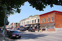
Petrolia is a town in southwestern Ontario, Canada. It is part of Lambton County and is surrounded by Enniskillen Township. It is billed as "Canada's Victorian Oil Town" and is often credited with starting the oil industry in North America.[2]
Lambton Central Collegiate & Vocational Institute (LCCVI) is the only high school located in Petrolia.
History[]

In 1857 James Miller Williams of Hamilton began distilling some of the "tar" lying around Oil Springs (located a few kilometers south from Petrolia), after buying the property rights from Charles Nelson Tripp. In July or August 1858 he struck an oil deposit in Oil Springs while digging a shallow well, sparking the oil drilling industry. In 2008, the 150th anniversary of the discovery, Canada Post issued a stamp commemorating this first commercial oil well, featuring portraits of Charles Tripp and Williams.[3] However, these early wells resulted in a large amount of wastage from gushers, estimated at 5 million barrels (790,000 m3) of oil in 1862 alone.[4][5]
Petrolia got its start in 1866 when a major gas well was found, resulting in an oil boom that caused many to abandon Oil Springs in favour of this new settlement. The place separated from Enniskillen Township and was incorporated as a town on 25 December of that same year.[6]
Oil production went through several boom periods in Petrolia; one was in 1898 and another in 1938. Some wells sunk in 1938 were initially producing 100 barrels per day (16 m3/d) at a price of $2 per barrel. This output, however, often lasted only a few weeks, falling to less than a barrel a day.[7]
Oil men from Petrolia travelled to the far reaches of the world (Gobi Desert, Arctic, Iran, Indonesia, United States, Australia, Russia, and over 80 other countries) teaching others how to find and extract crude oil. Those born and raised in Petrolia are referred to as "Hard Oilers", paying tribute to the toughness of their ancestors. Petrolia is also home to the Petrolia Discovery museum (currently closed for renovations)[when?]. Some oil fields in the area are still operational to this day.
Media and entertainment[]
Petrolia is home to Victoria Hall, a National Historic Site of Canada.[8] Originally a fire hall, municipal office, police hall, jail and opera house, it was completed in 1889 for a total cost of $35 000. In January 1989, a fire caused extensive damage. It was subsequently restored, and re-opened in 1992. Currently it houses the town hall and Victoria Playhouse.[9]
Until September 2013, The Petrolia Topic was the sole newspaper in the town of Petrolia. It is owned by Osprey Media. In September 2013, The Independent[10] of Petrolia & Central Lambton began publication.
The Oil Heritage District Community Centre was opened in Petrolia in 2006, after twenty years of campaigning by the group "The Oil Heritage District Community Centre Association" which was started in 1985. It serves rural and town residents in central Lambton County.
Climate[]
| hideClimate data for Petrolia (1981–2010) | |||||||||||||
|---|---|---|---|---|---|---|---|---|---|---|---|---|---|
| Month | Jan | Feb | Mar | Apr | May | Jun | Jul | Aug | Sep | Oct | Nov | Dec | Year |
| Record high °C (°F) | 15.0 (59.0) |
21.0 (69.8) |
26.5 (79.7) |
31.5 (88.7) |
33.5 (92.3) |
39.5 (103.1) |
38.0 (100.4) |
38.0 (100.4) |
35.0 (95.0) |
29.4 (84.9) |
23.3 (73.9) |
18.5 (65.3) |
39.5 (103.1) |
| Average high °C (°F) | −1.3 (29.7) |
0.6 (33.1) |
5.8 (42.4) |
13.0 (55.4) |
19.8 (67.6) |
25.2 (77.4) |
27.7 (81.9) |
26.4 (79.5) |
22.6 (72.7) |
15.3 (59.5) |
8.0 (46.4) |
1.6 (34.9) |
13.7 (56.7) |
| Daily mean °C (°F) | −5 (23) |
−3.5 (25.7) |
1.1 (34.0) |
7.6 (45.7) |
13.8 (56.8) |
19.1 (66.4) |
21.7 (71.1) |
20.7 (69.3) |
16.9 (62.4) |
10.4 (50.7) |
4.3 (39.7) |
−1.8 (28.8) |
8.8 (47.8) |
| Average low °C (°F) | −8.6 (16.5) |
−7.5 (18.5) |
−3.6 (25.5) |
2.1 (35.8) |
7.7 (45.9) |
13.0 (55.4) |
15.7 (60.3) |
15.0 (59.0) |
11.1 (52.0) |
5.5 (41.9) |
0.6 (33.1) |
−5.1 (22.8) |
3.8 (38.8) |
| Record low °C (°F) | −30.0 (−22.0) |
−27.0 (−16.6) |
−25.0 (−13.0) |
−13.0 (8.6) |
−2.5 (27.5) |
−1.7 (28.9) |
5.6 (42.1) |
2.0 (35.6) |
−2.0 (28.4) |
−7.2 (19.0) |
−17.2 (1.0) |
−22.0 (−7.6) |
−30.0 (−22.0) |
| Average precipitation mm (inches) | 66.2 (2.61) |
56.6 (2.23) |
62.5 (2.46) |
86.9 (3.42) |
87.0 (3.43) |
90.1 (3.55) |
75.7 (2.98) |
81.8 (3.22) |
107.3 (4.22) |
81.7 (3.22) |
89.3 (3.52) |
75.5 (2.97) |
960.6 (37.82) |
| Average rainfall mm (inches) | 26.9 (1.06) |
31.4 (1.24) |
44.6 (1.76) |
83.6 (3.29) |
87.0 (3.43) |
90.1 (3.55) |
75.7 (2.98) |
81.8 (3.22) |
107.3 (4.22) |
81.6 (3.21) |
83.5 (3.29) |
49.3 (1.94) |
842.7 (33.18) |
| Average snowfall cm (inches) | 39.2 (15.4) |
25.2 (9.9) |
17.9 (7.0) |
3.3 (1.3) |
0.0 (0.0) |
0.0 (0.0) |
0.0 (0.0) |
0.0 (0.0) |
0.0 (0.0) |
0.1 (0.0) |
5.8 (2.3) |
26.2 (10.3) |
117.8 (46.4) |
| Average precipitation days (≥ 0.2 mm) | 16.4 | 12.7 | 13.7 | 15.5 | 13.0 | 11.8 | 11.3 | 11.5 | 12.0 | 13.5 | 15.3 | 15.0 | 161.5 |
| Average rainy days (≥ 0.2 mm) | 6.3 | 6.3 | 9.5 | 14.8 | 13.0 | 11.8 | 11.3 | 11.5 | 12.0 | 13.5 | 13.9 | 9.3 | 133.2 |
| Average snowy days (≥ 0.2 cm) | 11.3 | 7.9 | 6.0 | 1.6 | 0.0 | 0.0 | 0.0 | 0.0 | 0.0 | 0.08 | 2.1 | 7.8 | 36.8 |
| Source: Environment Canada[11] | |||||||||||||
Demographics[]
| Year | Pop. | ±% |
|---|---|---|
| 1991 | 4,598 | — |
| 1996 | 4,908 | +6.7% |
| 2001 | 4,849 | −1.2% |
| 2006 | 5,222 | +7.7% |
| 2011 | 5,528 | +5.9% |
| 2016 | 5,742 | +3.9% |
| [12][13][1] | ||
| hideCanada census – Petrolia, Ontario community profile | |||
|---|---|---|---|
| 2016 | 2011 | 2006 | |
| Population: | 5,742 (3.9% from 2011) | 5,528 (5.9% from 2006) | 5,222 (7.7% from 2001) |
| Land area: | 12.68 km2 (4.90 sq mi) | 12.68 km2 (4.90 sq mi) | 12.68 km2 (4.90 sq mi) |
| Population density: | 452.8/km2 (1,173/sq mi) | 435.8/km2 (1,129/sq mi) | 411.7/km2 (1,066/sq mi) |
| Median age: | 43.0 (M: 41.5, F: 44.7) | 40.3 (M: 37.8, F: 42.4) | |
| Total private dwellings: | 2,323 | 2,223 | 2,082 |
| Median household income: | $72,741 | $60,157 | |
| References: 2016[14] 2011[13] 2006[15] earlier[16] | |||
Notable people[]
- Donald Ferguson Brown, a Canadian former politician, barrister and lawyer.
- Dale Hunter, a retired professional hockey player, and current OHL coach of the London Knights; former head coach of the Washington Capitals.
- Dave Hunter, a retired professional ice hockey player who won three Stanley Cups with the Edmonton Oilers in the 1980s
- Mark Hunter, a retired professional hockey player and currently co-owner (with Yeah brother Dale Hunter), and general manager of the London Knights OHL hockey team.
- Michael Leighton, former professional ice hockey goaltender who played for the Carolina Hurricanes, Philadelphia Flyers, Chicago Blackhawks and the Nashville Predators.
- John Van Boxmeer, a retired professional ice hockey player with the Montreal Canadiens who then transitioned to coaching at the professional level in both the NHL and Europe.
- Levi Oliver - Actor and musician. Notable appearance starring alongside Roddy Piper and Nick Mancuso in the film Blind Eye (2005)
- Peter Schiemann - one of the 4 Royal Canadian Mounted Police constables killed in the Mayerthorpe tragedy
See also[]
References[]
- ^ Jump up to: a b c "Petrolia census profile". 2016 Census of Population. Statistics Canada. Retrieved 18 March 2017.
- ^ "Oil Springs". Oil Museum of Canada. Archived from the original on 7 August 2008.
- ^ "Industries: Oil and Gas". Canada Post Corporation. Archived from the original on 9 October 2012.
- ^ Gulless, Micky; Earle Gray; Robert Bott. "Petroleum History Society - Canadian Beginnings". The Petroleum History Society. Retrieved 7 February 2006.
- ^ Gray, Earle (2008). "Gesner and Williams: two Canadians who launched the world's petroleum industry" (PDF). Retrieved 31 December 2008.[dead link]
- ^ "History of Oil Springs". The Village of Oil Springs. Archived from the original on 6 July 2011. Retrieved 23 February 2011.
- ^ Trestain, W.G. (15 July 1939). "unknown". The London Free Press. Cite uses generic title (help)
- ^ Victoria Hall / Petrolia Town Hall National Historic Site of Canada. Canadian Register of Historic Places.
- ^ "About the Victoria Playhouse Petrolia". Archived from the original on 3 August 2007. Retrieved 8 August 2007.
- ^ "The Oil Heritage District Community Centre Association celebrated for excellence" (PDF) (Press release). Foundation for Rural Living. 12 April 2006. Archived from the original (PDF) on 17 July 2011. Retrieved 8 December 2008.
- ^ "Petrolia Town, Ontario". Canadian Climate Normals 1981–2010 (in English and French). Environment Canada. Archived from the original on 23 July 2019. Retrieved 22 July 2019.
- ^ Statistics Canada: 1996, 2001, 2006 census
- ^ Jump up to: a b "2011 Community Profiles". 2011 Canadian Census. Statistics Canada. 5 July 2013. Retrieved 9 February 2012.
- ^ "2016 Community Profiles". 2016 Canadian Census. Statistics Canada. 21 February 2017. Retrieved 17 June 2019.
- ^ "2006 Community Profiles". 2006 Canadian Census. Statistics Canada. 30 March 2011. Retrieved 9 February 2012.
- ^ "2001 Community Profiles". 2001 Canadian Census. Statistics Canada. 17 February 2012.
External links[]
| Wikimedia Commons has media related to Petrolia, Ontario. |
| Wikisource has the text of the 1905 New International Encyclopedia article "Petrolea". |
| show Places adjacent to Petrolia, Ontario |
|---|
| show Authority control |
|---|
- Towns in Ontario
- Lower-tier municipalities in Ontario
- Municipalities in Lambton County
- History of the petroleum industry in Canada