
Pherzawl district
This article needs additional citations for verification. (October 2019) |
Pherzawl district | |
|---|---|
District of Manipur | |
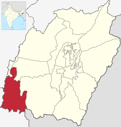 Location of Pherzawl district in Manipur | |
| Coordinates (Pherzawl): 24°15′N 93°11′E / 24.250°N 93.183°E | |
| Country | |
| State | |
| Established | 2016 |
| Headquarters | Pherzawl |
| Area | |
| • Total | 2,285 km2 (882 sq mi) |
| Population | |
| • Total | 47,250 |
| • Density | 21/km2 (54/sq mi) |
| Demographics | |
| • Literacy | 79% |
| Time zone | UTC+05:30 (IST) |
| Vehicle registration | MN0 |
| Major highways | NH-150, NH-2 |
| Website | pherzawldistrict |
Pherzawl (Pron:/ˌpherˈzâwl/) is a district of Manipur state in India.
Location and politics[]
Pherzawl District is located in the southern part of the state of Manipur. It is bounded on the east by Churachandpur District; on the north by Tamenglong District, Noney District and Jiribam district; on the west by the Cachar District of Assam and on the South by , Mizoram. Pherzawl District is located between 93° 11' 16.0440' East Longitude and 24° 15' 43.0524' North Latitude and is in the southern part of Manipur state. Pherzawl District has approximately 200 villages, according to the government's record.
The Pherzawl District came into existence on 8 December 2016 by joining 55-AC Tipaimukh (ST) and 56-AC Thanlon (ST) with its headquarters at Pherzawl. Despite the controversy surrounding the creation of seven new revenue districts in Manipur, the people of Pherzawl District welcomed the decision with celebrations[1] on 16 December 2016, when Manipur Chief Minister inaugurated the administrative centre at Pherzawl village.
Transport
Pherzawl is connected with the state capital Imphal via roads. A bus service running between Imphal and Pherzawl began in 2017.[2]
Climate and geography[]
The district is under humid subtropical climate. The soil is moderately fertile with clay loam soil with little patches of clay and loam. The temperature ranges from a minimum of 3.4 °C (38.1 °F) to a maximum of 34.1 °C (93.4 °F). The annual rainfall ranges from 670 to 1,450 mm (26 to 57 in). The elevation of the District is 1037 meters, or 3,402 feet.
References[]
- ^ "Pherzawl District Inauguration (Night Programme)". YouTube. 20 December 2016. Retrieved 8 May 2019.
- ^ "Archived copy". www.zoramobserver.com. Archived from the original on 2 August 2018. Retrieved 12 January 2022.
{{cite web}}: CS1 maint: archived copy as title (link)
External links[]
Places adjacent to Pherzawl district | ||||||||||||||||
|---|---|---|---|---|---|---|---|---|---|---|---|---|---|---|---|---|
| ||||||||||||||||
| State symbols | |
|---|---|
| Topics |
|
| Languages | |
| Administration |
|
| Districts | |
| Municipal Corporation | |
| Municipalities |
|
| Town Councils |
|
| Minor Townships | |
| Sport | |
- Pherzawl district
- Districts of Manipur
- Minority Concentrated Districts in India
- 2016 establishments in Manipur
- Constituencies established in 2016
- Hmar