Senapati district
hideThis article has multiple issues. Please help or discuss these issues on the talk page. (Learn how and when to remove these template messages)
|
Senapati district | |
|---|---|
District of Manipur | |
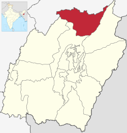 Location of Senapati district in Manipur | |
| Country | |
| State | |
| Headquarters | Senapati (Tahamzam) |
| Tehsils | 1. Purul, 2. , 3. ,[1] |
| Government | |
| • Lok Sabha constituencies | 1. 47-, 2. 48-Mao, 3. 49-Tadubi[1] |
| • Vidhan Sabha constituencies | 6 |
| Area | |
| • Total | 3,271 km2 (1,263 sq mi) |
| Population (2011) | |
| • Total | 479,148[2] |
| • Urban | 3.86%[2] |
| Demographics | |
| • Literacy | 74.13%[2] |
| • Sex ratio | 959[2] |
| Time zone | UTC+05:30 (IST) |
| Vehicle registration | MN03[3] |
| Major highways | NH-39, AH-2,[4] AH-1[5] |
| Website | senapati |
Senapati is of the 16 districts of Manipur state in India.
Geography[]
Senapati District is located between 93.29° and 94.15° East Longitude and 24.37° and 25.37° North Latitude and is in the northern part of Manipur state. The District is bounded on the south by Kangpokpi District, on the east by Ukhrul District, on the west by Tamenglong District and on the north by Kohima District and Phek district of Nagaland state. The district lies at an altitude between 1061 meter to 1788 meters above sea level.
Demographics[]
According to the 2011 census Senapati district has a population of 479,148,[6] roughly equal to the nation of Belize.[7] This gives it a ranking of 565th in India (out of a total of 640).[6] The district has a population density of 109 inhabitants per square kilometre (280/sq mi) .[6] Its population growth rate over the decade 2001-2011 was 25.16%.[6] Senapati has a sex ratio of 939 females for every 1000 males,[6] and a literacy rate of 75%.[6]
See also[]
References[]
- ^ Jump up to: a b http://senapati.nic.in/adminsetup.htm
- ^ Jump up to: a b c d "Senapati District Population Census 2011-2021, Manipur literacy sex ratio and density".
- ^ "娱乐是一种态度".
- ^ AH2
- ^ AH1
- ^ Jump up to: a b c d e f "District Census 2011". Census2011.co.in. 2011. Retrieved 30 September 2011.
- ^ US Directorate of Intelligence. "Country Comparison:Population". Retrieved 1 October 2011.
Belize 321,115 July 2011 est.
External links[]
| show Places adjacent to Senapati district |
|---|
| Authority control |
|
|---|
- Senapati district
- Districts of Manipur
- Minority Concentrated Districts in India
- 1969 establishments in Manipur