Philippine Institute of Volcanology and Seismology
| Surian ng Pilipinas sa Bulkanolohiya at Sismolohiya | |
 | |
 | |
| Agency overview | |
|---|---|
| Formed | September 17, 1982 |
| Preceding agencies |
|
| Jurisdiction | Philippines |
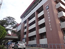
| Headquarters | C.P. Garcia Avenue, UP Campus, Diliman, Quezon City 14°39′6.94″N 121°3′30.68″E / 14.6519278°N 121.0585222°E |
| Annual budget | ₱529.18 million (2021)[1] |
| Agency executive |
|
| Parent agency | Department of Science and Technology |
| Website | www |

The Philippine Institute of Volcanology and Seismology (PHIVOLCS, Tagalog: [ˈfivolks]; Filipino: Surian ng Pilipinas sa Bulkanolohiya at Sismolohiya[2]) is a Philippine national institution dedicated to provide information on the activities of volcanoes, earthquakes, and tsunamis, as well as other specialized information and services primarily for the protection of life and property and in support of economic, productivity, and sustainable development. It is one of the service agencies of the Department of Science and Technology.
PHIVOLCS monitors volcano, earthquake, and tsunami activity, and issues warnings as necessary. It is mandated to mitigate disasters that may arise from such volcanic eruptions, earthquakes, tsunamis, and other related geotectonic phenomena.[3]
History[]
This government organization was formed after a historical merging of official functions of government institutions.
One of its first predecessors is the Philippine Weather Bureau created in 1901[4] when meteorological, seismological and terrestrial magnetic services of the Manila Observatory were transferred from the Roman Catholic Church to the American Colonial Government. It performed earthquake monitoring in the country and has inherited and maintained the early earthquake catalogue at that time. By 1972, the Philippine Weather Bureau was reorganized under Presidential Decree No. 78[5] into the Philippine Atmospheric Geophysical and Astronomical Services Administration (PAGASA). A UNDP-funded project for PAGASA established a twelve-station earthquake monitoring network in the country.
The other predecessor to PHIVOLCS, the Commission on Volcanology (COMVOL) was created on June 20, 1952 by Republic Act no. 766[6] after the disastrous eruption of Hibok-Hibok Volcano in June 1952.[7] Under Executive Order no. 784 of March 17, 1982, the umbrella department of COMVOL, the National Science Development Board (NSDB) was reorganized into the National Science and Technology Authority (NSTA), and COMVOL was restructured to become the Philippine Institute of Volcanology or PHIVOLC.[8]
The seismological arm of PAGASA was officially transferred to PHIVOLC[9] on September 17, 1984 through Executive Order No. 984, renaming the institute as the Philippines Institute of Volcanology and Seismology or PHIVOLCS.[10] NSTA, the umbrella department for PHIVOLCS and PAGASA, became the Department of Science and Technology (DOST) in 1987. The technical staff and the 12-station earthquake monitoring network was fully integrated to PHIVOLCS in 1988.
PHILVOCS and the United States Geological Survey collaborated during the 1991 eruption of Mount Pinatubo. Their forecast provided the timely evacuation of military personnel and residents that were affected by the eruption.[11]
PHIVOLCS was headed by Raymundo Punongbayan from 1982 to 2002,[12] and it is currently headed by Renato U. Solidum Jr. from 2003 to the present.
Classification of volcanoes in the Philippines[]

The Philippine Institute of Volcanology and Seismology provides a classification system for the volcanoes of the country.[13]
Active[]
- Eruption in historic times
- Historical record within 600 years
- Radiocarbon dating (C14) dating to 10,000 years
- Local seismic activity
- Oral or folkloric history

Potentially active[]
- Active solfataras, fumaroles, or steaming activity
- Geologically young, possibly erupted < 10,000 years and for calderas and large systems, possibly < 25,000 years.
- Young-looking geomorphology (thin soil cover or sparse vegetation; low degree of erosion and dissection; young vent features; with or without vegetation cover).
- Suspected seismic activity.
- Documented local ground deformation.
- Geochemical indicators of magmatic involvement.
- Geophysical proof of magma bodies.
- Strong connection with subduction zones and external tectonic settings.
Inactive[]
- No record of eruption and its form is beginning to change by the agents of weathering and erosion via formation of deep and long gullies.
See also[]
- PHIVOLCS Earthquake Intensity Scale
- Geography of the Philippines
- List of volcanoes in the Philippines
- Manila Observatory
References[]
- ^ "M. PHILIPPINE INSTITUTE OF VOLCANOLOGY AND SEISMOLOGY" (PDF). Department of Budget and Management. Retrieved August 5, 2021.
- ^ Narvaez, Eilene Antoinette; Macaranas, Edgardo, eds. (2013). Mga Pangalan ng Tanggapan ng Pamahalaan sa Filipino (PDF) (in Filipino) (2013 ed.). Komisyon sa Wikang Filipino. p. 30. ISBN 978-971-0197-22-4. Retrieved December 27, 2018.
- ^ "About PHIVOLCS". PHIVOLCS website. Retrieved December 4, 2008.
- ^ Soliven, Preciosa S. (July 21, 2011). "The Jesuit Manila Observatory, 1865-2011 (Part I)". Philstar.com. Retrieved August 6, 2021.
- ^ "PRESIDENTIAL DECREE No. 78 ESTABLISHING THE PHILIPPINE ATMOSPHERIC GEOPHYSICAL AND ASTRONOMICAL SERVICES ADMINISTRATION". www.officialgazette.gov.ph. Retrieved August 6, 2021.
- ^ "Republic Act No. 766 : REPUBLIC ACTS - PHILIPPINE LAWS STATUTES and CODES". laws.chanrobles.com. June 20, 1952. Retrieved August 6, 2021.
- ^ McCall, G.; Laming, D.; Scott, S. (March 8, 2013). Geohazards: Natural and man-made. Springer Science & Business Media. p. 17. ISBN 978-94-009-0381-4. Retrieved August 6, 2021.
- ^ "EXECUTIVE ORDER NO. 784 REORGANIZING THE NATIONAL SCIENCE DEVELOPMENT BOARD AND ITS AGENCIES INTO A NATIONAL SCIENCE AND TECHNOLOGY AUTHORITY AND FOR RELATED PURPOSES". www.officialgazette.gov.ph. March 17, 1982. Retrieved August 6, 2021.
- ^ Bankoff, Greg (2003). Cultures of Disaster: Society and Natural Hazards in the Philippines. Psychology Press. p. 84. ISBN 978-0-7007-1761-3. Retrieved August 6, 2021.
- ^ "EXECUTIVE ORDER NO. 984 TRANSFERRING THE PHILIPPINE ATMOSPHERIC, GEOPHYSICAL AND ASTRONOMICAL SERVICES ADMINISTRATION TO THE NATIONAL SCIENCE AND TECHNOLOGY AUTHORITY, PROVIDING FOR ITS REORGANIZATION, AND FOR OTHER PURPOSES". www.officialgazette.gov.ph. September 17, 1984. Retrieved August 6, 2021.
- ^ Rinard Hinga, Bethany D. (March 17, 2015). Ring of Fire: An Encyclopedia of the Pacific Rim's Earthquakes, Tsunamis, and Volcanoes: An Encyclopedia of the Pacific Rim's Earthquakes, Tsunamis, and Volcanoes. ABC-CLIO. p. 247. ISBN 978-1-61069-297-7. Retrieved August 6, 2021.
- ^ "Raymundo S. Punongbayan, 68; Leading Volcanologist". Los Angeles Times. May 6, 2005. Retrieved August 6, 2021.
- ^ "Volcano General Information"
External links[]
| show Department of Science and Technology, Philippines |
|---|

| show Authority control |
|---|
Coordinates: 14°39′07″N 121°03′31″E / 14.652026°N 121.05854°E
- Department of Science and Technology (Philippines)
- Geology organizations
- Volcano observatories
- Seismological observatories, organisations and projects
- Volcanism of the Philippines
- Government agencies established in 1982
- 1982 establishments in the Philippines