Phlox, Indiana
Phlox, Indiana | |
|---|---|
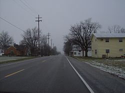 Along State Road 26 in Phlox | |
 Phlox | |
| Coordinates: 40°25′16″N 85°55′7″W / 40.42111°N 85.91861°WCoordinates: 40°25′16″N 85°55′7″W / 40.42111°N 85.91861°W | |
| Country | United States |
| State | Indiana |
| County | Howard |
| Township | Union |
| Elevation | 850 ft (260 m) |
| GNIS feature ID | 441096 |


Phlox is an unincorporated community in southern Union Township, Howard County, Indiana, United States. It lies at the intersection of State Road 26 with County Road 1100 East.[2]
Phlox is part of the Kokomo, Indiana Metropolitan Statistical Area.
Phlox is probably named after the local vegetation.[3]
Geography[]
Phlox is located at 40°25′16″N 85°55′7″W / 40.42111°N 85.91861°W.
References[]
- ^ "US Board on Geographic Names". United States Geological Survey. 2007-10-25. Retrieved 2008-01-31.
- ^ DeLorme. Indiana Atlas & Gazetteer. 3rd ed. Yarmouth: DeLorme, 2004, p. 33. ISBN 0-89933-319-2.
- ^ "A Look Back as We Move Forward". The Kokomo Tribune. March 28, 1999. p. 58. Retrieved August 16, 2014 – via Newspapers.com.

Municipalities and communities of Howard County, Indiana, United States | ||
|---|---|---|
| City | ||
| Towns | ||
| Townships | ||
| Other unincorporated communities | ||
| ||
This Howard County, Indiana location article is a stub. You can help Wikipedia by . |
Categories:
- Unincorporated communities in Howard County, Indiana
- Unincorporated communities in Indiana
- Kokomo, Indiana metropolitan area
- Central Indiana geography stubs