Pico Basilé
| Pico Basilé | |
|---|---|
| Pico de Santa Isabel | |
 | |
| Highest point | |
| Elevation | 3,011 m (9,879 ft)[1] |
| Prominence | 3,011 m (9,879 ft)[1] Ranked 90th |
| Isolation | 83 km (52 mi) |
| Listing | Country high point Ultra |
| Coordinates | 3°35′00″N 8°46′00″E / 3.58333°N 8.76667°ECoordinates: 3°35′00″N 8°46′00″E / 3.58333°N 8.76667°E[1] |
| Geography | |
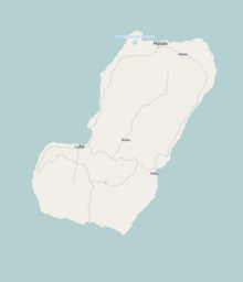 Pico Basilé Location of Pico Basilé in Bioko | |
| Location | Bioko, Equatorial Guinea |
| Geology | |
| Mountain type | Shield volcano |
| Last eruption | 1923 |

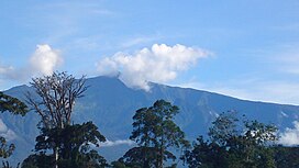
Pico Basilé (formerly Pico de Santa Isabel), located on the island of Bioko, is the tallest mountain of Equatorial Guinea. With an altitude of 9,878 ft (3,011 m), it is the summit of the largest and highest of three overlapping basaltic shield volcanoes which form the island. From the summit, Mt. Cameroon can be seen to the northeast. Pico Basilé lies close to the city of Malabo. The very top is used as a broadcast transmitting station for RTVGE (Radio Television Guinea Ecuatorial) and microwave relay station for various communication networks.
The peak forms a part of Pico Basilé National Park, created in April 2000[2] The boundaries of Bioko Norte and Sur runs near the summit.

Bioko was formed along the Cameroon line, a major northeast-trending geologic fault that runs from the Atlantic Ocean into Cameroon. This line includes other volcanic islands in the Gulf of Guinea such as Annobón, Príncipe and São Tomé, along with the massive stratovolcano of Mount Cameroon. Unlike the three other islands which are extinct volcanoes, its last eruption occurred in 1923.
Flora and fauna[]
Part of the Cameroon line, the flora and fauna of Pico Basilé and Bioko as a whole are similar to that of the montane regions of adjacent Cameroon and Nigeria. Multiple range restricted species occur on Pico Basilé, and one bird, the Bioko Speirops Zoterops brunneus, is wholly restricted to the volcano's higher elevations.[3]
History[]
The island was inhabited in the middle of the first millennium BC by Bantu tribes from the mainland, who formed the Bubi ethnic group. Unlike other islands in the area, Bioko had an indigenous African population. The Bubi speak a Bantu language. The island has probably been inhabited by this or other Bantu-speaking groups since before the 7th century BC.
In 1472, the Portuguese navigator Fernão do Pó was the first European to sight the island while seeking a path to India.
The first ascent of the mountain by Europeans was made by English commanders between 1827 and 1828 under the Owen expedition. Its first official ascent was made in 1839 by the British John Beecroft who was later governor of the island that was once Fernando Po, now Bioko.[4]
See also[]
References[]
- ^ Jump up to: a b c "Africa Ultra-Prominences". Peaklist.org. Retrieved 2013-02-10.
- ^ Network for Protected areas in Equatorial Guinea Archived 2011-02-02 at the Wayback Machine (in French)
- ^ Pérez del Val, Jaime 1996. Las Aves de Bioko, Guinea Ecuatorial: Guia de Campo. Edilesa, Léon, Spain.
- ^ (1985). Connaître la Guinée équatoriale (in French). Peuples Noirs Peuples Africains. p. 27-92.
Sources[]
- "Santa Isabel". Global Volcanism Program. Smithsonian Institution.
- Bioko Biodiversity Protection Program
This Equatorial Guinea location article is a stub. You can help Wikipedia by . |
- Bioko
- Mountains of Equatorial Guinea
- Shield volcanoes of Equatorial Guinea
- Volcanoes of the Atlantic Ocean
- Highest points of countries
- Polygenetic shield volcanoes
- Equatorial Guinea geography stubs