Príncipe
 Map of São Tomé and Príncipe with Príncipe island near the right top corner | |
| Geography | |
|---|---|
| Location | São Tomé and Príncipe |
| Coordinates | 1°37′N 7°24′E / 1.617°N 7.400°ECoordinates: 1°37′N 7°24′E / 1.617°N 7.400°E |
| Area | 136 km2 (53 sq mi) |
| Highest elevation | 947 m (3107 ft) |
| Highest point | Pico de Príncipe |
| Administration | |
| Districts | 1 (Pagué) |
| Capital city | Santo António |
| Demographics | |
| Demonym | Príncipean or Principean |
| Population | 8,420 (2018) |
| Pop. density | 59.3/km2 (153.6/sq mi)[1] |
| Additional information | |
| Area code(s) | 00239-19x-xxxx? |

Príncipe is the smaller, northern major island of the country of São Tomé and Príncipe lying off the west coast of Africa in the Gulf of Guinea.[2] It has an area of 142 square kilometres (55 sq mi) (including offshore islets) and a population of 7,324 at the 2012 Census;[3] the latest official estimate (at May 2018) was 8,420.[1] The island is a heavily eroded volcano speculated to be over three million years old, surrounded by smaller islands including Ilheu Bom Bom, Ilhéu Caroço, Tinhosa Grande and Tinhosa Pequena. Part of the Cameroon Line archipelago, Príncipe rises in the south to 947 metres at Pico do Príncipe.[4] The island is the main constituent of the Autonomous Region of Príncipe, established in 1995, and of the coterminous district of Pagué.
History[]
The island was uninhabited when discovered by the Portuguese on 17 January 1471 and was first named after Saint Anthony ("Ilha de Santo Antão"). Later the island was renamed Príncipe by King John II of Portugal in honour of his son Afonso, Prince of Portugal. The first settlement, the town Santo António, was founded in 1502.[5] Subsequently, the north and centre of the island were made into plantations by Portuguese colonists using slave labor. These concentrated initially on producing sugar and after 1822 on cocoa, becoming the world's greatest cocoa producer.[6] Since independence, these plantations have largely reverted to forest.
The island's fortress named Fortaleza de Santo António da Ponta da Mina on a point inside Baía de Santo António (Santo António Bay) was built in 1695.[5] In 1706, the city and the fortress were destroyed by the French.[5] From 1753 until 1852, Santo António was the colonial capital of Portuguese São Tomé and Príncipe.[7]
Príncipe was the site where Einstein's theory of relativity was experimentally corroborated by Arthur Stanley Eddington and his team during the total solar eclipse of May 29, 1919; photographs of the eclipse revealed evidence of the 'bending' of starlight, in accordance with Einstein's predictions (see Eddington experiment).
On April 29, 1995, the Autonomous Region of Príncipe was established, corresponding with the existing Pagué District.[8]
Settlements[]
Príncipe has one town, Santo António, and an airport (IATA code: PCP, ICAO: FPPR). Some other smaller settlements are Sundy and Porto Real.
Demographics[]
Portuguese is the official and main language of the island. Portuguese creoles are also spoken: Principense or Lunguyê and, in some scale, Forro are also spoken.
In 1771, Príncipe had a population of 5,850: 111 whites, 165 free mulattoes, 6 mulatto slaves, 900 free blacks, and 4,668 black slaves. In 1875, the year when slavery was officially abolished in the archipelago, Príncipe's population had dropped to only 1,946, of whom 45 were Europeans, 1,521 were free natives, and 380 were freemen.
Nature[]
In 2006, the Parque Natural Obô do Príncipe was established, covering the mountainous, densely forested and uninhabited southern part of the island of Príncipe.[9] There are numerous endemic species of fauna on Príncipe, including birds such as the Príncipe kingfisher, Principe seedeater, Principe starling, Príncipe sunbird, black-capped speirops (Zosterops lugubris), Dohrn's thrush-babbler, the Príncipe weaver and the Príncipe white-eye, geckos include the Príncipe gecko (Hemidactylus principensis), frogs include the palm forest tree frog and the Phrynobatrachus dispar. Marine fauna includes Muricopsis principensis, a mollusc and the West African mud turtle.
Ecological reserve[]
UNESCO established the Island of Príncipe Biosphere Reserve in 2012 under the Man and the Biosphere Programme. The reserve encompasses the entire emerged area of the island of Príncipe, and its islets Bom Bom, Boné do Jóquei, Mosteiros, Santana, and Pedra da Galei, and the Tinhosas islands.[10]
Notable people[]
- Damião Vaz d'Almeida, former Prime Minister of São Tomé and Príncipe
- João Paulo Cassandra, former autonomous president of the island
- José Cassandra, current president of the island
- Sara Pinto Coelho, colonial born Portuguese writer
- Camilo Domingos, singer
- Manuela Margarido, writer
- Nuno Espírito Santo, association football goalkeeper and manager
Gallery[]

Praia do Boi, in Príncipe

Praia das Bananas, São Tomé and Príncipe
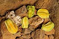
Carambola in Príncipe

Lagoa do Caixão, Príncipe Island
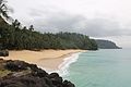
Beach in Príncipe

Igreja de Nossa Senhora da Conceição, in Santo António, São Tomé and Príncipe.

Bom Bom Islet, Príncipe


References[]
- ^ Jump up to: a b Instituto Nacional de Estatística.
- ^ "Satellite View and Map of São Tomé and Príncipe" Nations Online. Retrieved 2014-9-26.
- ^ Projecção a nível distrital 2012 - 2020[permanent dead link], Instituto Nacional de Estatística
- ^ Sailing Directions (Enroute), Pub. 123: Southwest Coast of Africa (PDF). Sailing Directions. United States National Geospatial-Intelligence Agency. 2017. p. 74.
- ^ Jump up to: a b c Santo António, Heritage of Portuguese Influence
- ^ Pinnock, D & Pinnock, G (2012) Chocolate Island. Africa Geographic. February 2012
- ^ McKenna, Amy (2011). The History of Central and Eastern Africa. The Rosen Publishing Group. p. 73. ISBN 9781615303229 – via Google Books.
- ^ Cooperação Descentralizada Príncipe – Portugal: Eficiência da Existência de Redes de Cooperação (2010), Ana Maria Luciano Barreira, Universidade Técnica de Lisboa, p. 42-43
- ^ "Parque Natural do Príncipe". Retrieved 19 October 2018.
- ^ "World Network of Biosphere Reserves". Island of Príncipe. UNESCO. Retrieved 1 June 2016.
External links[]
 Definitions from Wiktionary
 Media from Wikimedia Commons
 News from Wikinews
 Quotations from Wikiquote
 Texts from Wikisource
 Textbooks from Wikibooks
 Resources from Wikiversity
- Map of Príncipe
- Principe portal
- "Príncipe: a haven on earth" Financial Times
 Wikimedia Atlas of São Tomé and Príncipe
 Sao Tome and Principe travel guide from Wikivoyage
- Príncipe at Curlie

| show |
|---|

| show Authority control |
|---|
- Príncipe
- Former Portuguese colonies
- Islands of São Tomé and Príncipe
- Volcanoes of the Atlantic Ocean
- Autonomous regions