Pine Ridge, Oklahoma
Pine Ridge, Oklahoma | |
|---|---|
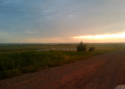 Sunset on June 6, 2009 at Pine Ridge | |
 Pine Ridge Location within the state of Oklahoma | |
| Coordinates: 35°01′7.5″N 98°28′5.31″W / 35.018750°N 98.4681417°WCoordinates: 35°01′7.5″N 98°28′5.31″W / 35.018750°N 98.4681417°W | |
| Country | United States |
| State | Oklahoma |
| County | Caddo |
| Elevation | 1,460 ft (450 m) |
| Time zone | UTC-6 (Central (CST)) |
| • Summer (DST) | UTC-5 (CDT) |


Pine Ridge is an unincorporated community[2] in Hale Township,[3] Caddo County, Oklahoma, United States. It is located 6 miles (10 km) south of Fort Cobb at the junction of County Road 1380 and County Street 2550.[4][5][6]
History[]
According to locals,[7] the community got its name from the community of Pine Ridge, Arkansas, that was the setting of the radio show Lum and Abner which aired from 1934 to 1952. Legend says that the owner of the grocery store named it "Pine Ridge" after the radio show and over time the name was adopted as the name of the whole community.[8]
During the community's heyday in the 1940s there was a hub of activity at the main junction of the Ozark Trail and the Fort Cobb road, with a grocery store and two churches, Hopewell Missionary Baptist Church and Pine Ridge Church of Christ (founded on May 1, 1949 but later merged into the Fort Cobb Church of Christ.[9][10] By the 1950 and 1960's the community went into a time of decline with the grocery store closing and eventually the closing of the churches, sometimes by way of merger with congregations in the neighboring communities of Fort Cobb, Apache and Carnegie.[citation needed] And in at least one case, an entire church building was moved from Pine Ridge to Saddle Mountain, a distance of approximately 25 miles.[11]
By the 1980s, the only visible signs of the community were the Pine Ridge Electrical sub-station, the remains of a church building and the Pleasant Valley Cemetery,[12]

This changed in the late 2010s when the 3 Megawatt Pine Ridge solar generation facility[13] was constructed at the Pine Ridge corner.
Present[]
Pine Ridge is located at the junction of the blacktop road going directly south from Fort Cobb and the old Ozark Trail.
The Pine Ridge community mostly consists of land dedicated to wheat and hay farming and cattle ranching, as well as the Pine Ridge solar generation facility.[14] There is also a winery east of Pine Ridge on the Ozark Trail (Woods and Waters Winery and Vineyard).
Public school students in Pine Ridge attended school at Broxton until the school district was consolidated with Fort Cobb in the 1990s. Telephone numbers for the Pine Ridge area are split between the Fort Cobb and Apache prefixes. Electric service is provided by CK Energy Electric Cooperative (merged from the former Caddo and Kiwash electric cooperatives in 2016).[15]
Pine Ridge is in State House District 56[16] and in State Senate District 26.[17]

Winter at Pine Ridge
Sunset on June 6, 2009 from Pine Ridge
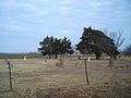
Pleasant View Cemetery


References[]
- ^ Pleasant View Cemetery, Caddo County OK
- ^ [1]
- ^ [2]
- ^ [3]
- ^ Oklahoma DOT Map: Caddo County (PDF download)
- ^ [4]
- ^ Interview with Lawrence McCullough by James M. Branum, cir. 1997
- ^ of Old Time Oklahoma by David Dary, 2011 OU Press, page 23
- ^ Photograph in the archives of James M. Branum, labeled "Pine Ridge - Church of Christ - Opening Day - May 1, 1949"
- ^ Church listings The Apache Review (Apache, Oklahoma) July 7, 1957 (accessed via Newspapers.com) - "Bible school Sunday at 9:45 am and 8 p.m. and Wednesday at 8 p.m. Preaching services at 11 a.m. and 8 p.m. Communion at 11:45 a.m. Evening worship 7:30 o'clock. You are always welcome at this friendly church."
- ^ Mountain View News (Oklahoma - April 5, 1956) - " The church building purchased by the members of the Church of Christ at Saddle Mt. was moved from the Pine Ridge community south of Ft. Cobb to the church building at the southeast corner of the Alton Delk home place, Friday."
- ^ [5]
- ^ "Oklahoma Electric Cooperative is a solar power generation leader" The Oklahoman (April 3, 2018)
- ^ "Oklahoma Electric Cooperative is a solar power generation leader" The Oklahoman (April 3, 2018)
- ^ [6]
- ^ House District 56 map that shows Pine Ridge (PDF download)
- ^ Senate District 26 map (PDF download)
| hide Municipalities and communities of Caddo County, Oklahoma, United States | ||
|---|---|---|
| City |  | |
| Towns | ||
| CDP | ||
| Other communities | ||
| Footnotes | ‡This populated place also has portions in an adjacent county or counties. | |
| ||
- Unincorporated communities in Caddo County, Oklahoma
- Unincorporated communities in Oklahoma