Pipe Creek Township, Miami County, Indiana
Pipe Creek Township | |
|---|---|
 Farmland in Pipe Creek Township | |
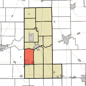 Location in Miami County | |
| Coordinates: 40°41′46″N 86°07′57″W / 40.69611°N 86.13250°WCoordinates: 40°41′46″N 86°07′57″W / 40.69611°N 86.13250°W | |
| Country | |
| State | |
| County | Miami |
| Organized | 6 September 1843 |
| Government | |
| • Type | Indiana township |
| Area | |
| • Total | 25.59 sq mi (66.3 km2) |
| • Land | 25.33 sq mi (65.6 km2) |
| • Water | 0.26 sq mi (0.7 km2) 1.02% |
| Elevation | 771 ft (235 m) |
| Population (2010) | |
| • Total | 6,294 |
| • Density | 248.5/sq mi (95.9/km2) |
| Time zone | UTC-5 (Eastern (EST)) |
| • Summer (DST) | UTC-4 (EDT) |
| ZIP codes | 46914, 46932, 46970 |
| GNIS feature ID | 453742 |

Pipe Creek Township is one of fourteen townships in Miami County, Indiana, United States. As of the 2010 census, its population was 6,294 and it contained 2,936 housing units.[2] The north three-quarters of Grissom Joint Air Reserve Base is in the southwest corner of the township.
History[]
Pipe Creek Township was organized by the county commissioners on September 6, 1843, and named for its largest stream, Pipe Creek.[3][4]
The B-17G "Flying Fortress" No. 44-83690 and Terrell Jacobs Circus Winter Quarters are listed on the National Register of Historic Places.[5][6]
Geography[]
According to the 2010 census, the township has a total area of 25.59 square miles (66.3 km2), of which 25.33 square miles (65.6 km2) (or 98.98%) is land and 0.26 square miles (0.67 km2) (or 1.02%) is water.[2]
Cities, towns, villages[]
Unincorporated towns[]
- Flora at 40°44′02″N 86°06′00″W / 40.733930°N 86.099993°W
- Nead at 40°42′26″N 86°07′39″W / 40.707263°N 86.127493°W
- Wells at 40°43′56″N 86°06′40″W / 40.732263°N 86.111104°W
Extinct towns[]
Cemeteries[]
The township contains these four cemeteries: Garnand, Leonda, Metzger and Springdale.
Major highways[]
Airports and landing strips[]
- Weed Field Airport
School districts[]
- Maconaquah School Corporation
Political districts[]
- Indiana's 5th congressional district
- State House District 23
- State House District 24
- State Senate District 18
References[]
- "Pipe Creek Township, Miami County, Indiana". Geographic Names Information System. United States Geological Survey. Retrieved 2009-09-29.
- United States Census Bureau 2008 TIGER/Line Shapefiles
- IndianaMap
- ^ "US Board on Geographic Names". United States Geological Survey. October 25, 2007. Retrieved 2017-05-09.
- ^ a b "Population, Housing Units, Area, and Density: 2010 - County -- County Subdivision and Place -- 2010 Census Summary File 1". United States Census. Archived from the original on 2020-02-12. Retrieved 2013-05-10.
- ^ Stephens, John H. (1896). "Pipe Creek Township". History of Miami County. Peru, Indiana: The John H. Stephens Publishing House.
- ^ Bodurtha, Arthur Lawrence (1914). History of Miami County, Indiana: A Narrative Account of Its Historical Progress, Its People and Its Principal Interests. Lewis Pub. pp. 139.
- ^ "National Register Information System". National Register of Historic Places. National Park Service. July 9, 2010.
- ^ "National Register of Historic Places Listings". Weekly List of Actions Taken on Properties: 4/02/12 through 4/06/12. National Park Service. 2012-04-13.
External links[]
- Indiana Township Association
- United Township Association of Indiana
- City-Data.com page for Pipe Creek Township
Places adjacent to Pipe Creek Township, Miami County, Indiana | |
|---|---|
Municipalities and communities of Miami County, Indiana, United States | ||
|---|---|---|
| City | ||
| Towns | ||
| Townships | ||
| CDP | ||
| Other unincorporated communities | ||
| Ghost towns | ||
| Footnotes | ‡This populated place also has portions in an adjacent county or counties | |
| ||
- Townships in Miami County, Indiana
- Townships in Indiana