Piz Sesvenna
| Piz Sesvenna | |
|---|---|
 Muntpitschen and Piz Sesvenna | |
| Highest point | |
| Elevation | 3,204 m (10,512 ft) |
| Prominence | 1,055 m (3,461 ft)[1] |
| Parent peak | Ortler |
| Isolation | 21.5 km (13.4 mi)[2] |
| Listing | Alpine mountains above 3000 m |
| Coordinates | 46°42′21.7″N 10°24′10.6″E / 46.706028°N 10.402944°ECoordinates: 46°42′21.7″N 10°24′10.6″E / 46.706028°N 10.402944°E |
| Geography | |
 Piz Sesvenna Location in Switzerland | |
| Location | Graubünden, Switzerland (mountain partially in Italy) |
| Parent range | Sesvenna Range |

Piz Sesvenna is the highest mountain in the Sesvenna Range of the Alps. It lies between the Swiss canton of Graubünden and the Italian region of South Tyrol. The summit is located within Switzerland, very close to the Italian border and main watershed.
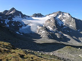
On the north side of Piz Sesvenna lies a glacier named Vadret da Sesvenna.
The closest locality is S-charl, south of Scuol in the Engadin valley.
See also[]
- List of most isolated mountains of Switzerland
References[]
- ^ Retrieved from the Swisstopo topographic maps. The key col is the Ofen Pass (2,149 m).
- ^ Retrieved from Google Earth. The nearest point of higher elevation is south of the Muttler.
External links[]
This Graubünden location article is a stub. You can help Wikipedia by . |
Categories:
- Mountains of Graubünden
- Mountains of the Alps
- Alpine three-thousanders
- Mountains partially in Italy
- Mountains of Switzerland
- Graubünden geography stubs