Planes, Alicante
This article does not cite any sources. (July 2009) |
Planes | |
|---|---|
Municipality | |
| Planes de la Baronia --> | |
 | |
 Flag  Coat of arms | |
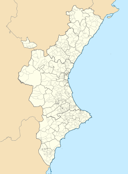
 Planes Location of Planes within Spain / Valencian Community | |
| Coordinates: 38°47′07″N 0°20′42″W / 38.78528°N 0.34500°WCoordinates: 38°47′07″N 0°20′42″W / 38.78528°N 0.34500°W | |
| Country | |
| Autonomous Community | |
| Province | Alicante |
| Comarca | Comtat |
| Government | |
| • Type | Mayor-council government |
| • Body | Ajuntament de Planes |
| • Mayor | (2015) ( |
| Area | |
| • Total | 38.9 km2 (15.0 sq mi) |
| Elevation | 472 m (1,549 ft) |
| Population (2018)[1] | |
| • Total | 713 |
| • Density | 18/km2 (47/sq mi) |
| Demonym(s) | Planero, -ra (es) planer, ra (va) |
| Time zone | CET (GMT +1) |
| • Summer (DST) | CEST (GMT +2) |
| Postcode | 03828 |
| Website | City Hall of Planes |


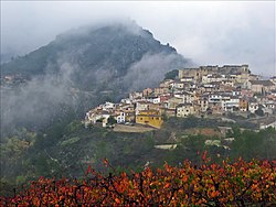
Planes (Valencian and Spanish: [ˈplanes]) is a municipality in Spain. This hamlet lies in the Comtat region of the Spanish kingdom.
References[]
- ^ Municipal Register of Spain 2018. National Statistics Institute.
External links[]
 Media related to Planes (Comtat) at Wikimedia Commons
| show Municipalities of the province of Alicante |
|---|
| show Authority control |
|---|
This article about a location in the Valencian Community, Spain, is a stub. You can help Wikipedia by . |
Categories:
- Municipalities in the Province of Alicante
- Valencian Community geography stubs