Plantsville, Connecticut
This article needs additional citations for verification. (June 2009) |
Plantsville Historic District | |
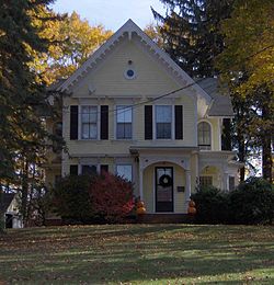 Charles Cowles House | |
 | |
| Location | Roughly bounded by Prospect St., Summer St., Quinnipiac River, Grove St., S. Main St., W. Main St., and West St., Southington, Connecticut |
|---|---|
| Coordinates | 41°35′26″N 72°53′35″W / 41.59056°N 72.89306°WCoordinates: 41°35′26″N 72°53′35″W / 41.59056°N 72.89306°W |
| Architect | Cady, Josiah Cleveland |
| Architectural style | Greek Revival, Italianate, Queen Anne |
| NRHP reference No. | 88002673[1] |
| Added to NRHP | December 1, 1988 |


Plantsville is a neighborhood in the town of Southington, Hartford County, Connecticut.[2] It is centered at the merger between South Main Street (road from the Milldale section) and West Main Street (road from the Marion section). As of the 2000 Census there were 10,387 people living in the Zip Code Tabulation Area for zip code 06479, which is assigned the postal city name Plantsville.[3] The Zip Code Tabulation Area includes the entire southwestern corner of the town of Southington, including Marion and Milldale. Beginning in 2015 Plantsville (not including Marion and Milldale) was listed as a census-designated place.[4]
Geography[]
Plantsville is located in the south-central part of Southington at geographical coordinates 41° 34′ 56" North, 72° 53′ 25" West (41.5824, -72.8904). It is just south of the town center of Southington. The CDP border follows Prospect Street and Carter Lane on the north side, Old Turnpike Road on the east, Mulberry Street on the south, and Atwater Street and Interstate 84 on the west.[5] Connecticut Route 10 (Main Street) passes through the center of Plantsville, leading north to the center of Southington and south to Cheshire.
The Quinnipiac River flows through the community, just west of Route 10.
1962 Tornado[]
On May 24, 1962, the neighborhood was partially flattened by a high-end F3 tornado. The tornado, which was "near-F4" intensity at the time, damaged or destroyed numerous buildings, homes, businesses, and vehicles throughout the area. Overall, the storm left one dead and 50 injured.[6][7][8][9][10][11][12]
Demographics[]
At the time of the 2000 Census there was a total of 10,387 people living within the Plantsville Zip Code Tabulation Area. The Median Age was 38.3.[3] The median home value in Plantsville is $255,500.[13]
Attractions[]
The Plantsville Historic District is a historic district that was listed on the National Register of Historic Places in 1988.[1] The district was recognized for its diversity of 19th and early 20th-century residential and industrial architecture, encompassing a century's development of the community as an industrial village. Notable buildings include the 1866 Plantsville Congregational Church, one of the state's finest examples of Gothic Revival architecture, designed by Josiah Cleveland Cady.[14]
Education[]
There are three schools located in Plantsville: Plantsville School, Strong Elementary School, and John F. Kennedy Middle School.

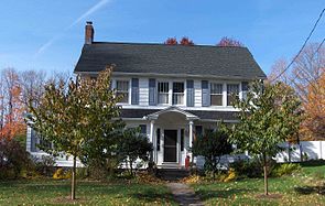
Twichell/Ward House
100 Church Street

Congregational Church


See also[]
References[]
- ^ Jump up to: a b "National Register Information System". National Register of Historic Places. National Park Service. March 13, 2009.
- ^ U.S. Geological Survey Geographic Names Information System: Plantsville, Connecticut
- ^ Jump up to: a b U.S. Census data for Plantsville Zip Code Tabulation Area (06479)
- ^ "Geographic Identifiers: 2010 Demographic Profile Data (G001): Plantsville CDP, Connecticut". American Factfinder. U.S. Census Bureau. Retrieved April 24, 2017.[dead link]
- ^ "TIGERweb". Geography Division, U.S. Census Bureau. Retrieved April 24, 2017.
- ^ "Storm Data Publication | IPS | National Climatic Data Center (NCDC)". www.ncdc.noaa.gov. Retrieved 24 August 2020.
- ^ "Connecticut F3". Tornado History Project. Storm Prediction Center. Retrieved 23 September 2020.
- ^ Connecticut Event Report: F3 Tornado. National Weather Service (Report). National Center for Environmental Information. Retrieved 23 September 2020.
- ^ Connecticut Event Report: F3 Tornado. National Weather Service (Report). National Center for Environmental Information. Retrieved 23 September 2020.
- ^ American, Republican. "The Day of the Tornado | Republican American Archives". Retrieved 23 September 2020.
- ^ "Florence T Crowell's Historic Watertown Connecticut Photo Gallery". www.facebook.com. Retrieved 23 September 2020.
- ^ "News". web.tapr.org. Retrieved 23 September 2020.
- ^ "ZIP Code 06479 Map, Housing Stats, More for Plantsville, CT". www.unitedstateszipcodes.org. Retrieved 2017-04-18.
- ^ "NRHP nomination for Plantsville Historic District". National Park Service. Retrieved 2017-07-14.
External links[]
| show Municipalities and communities of Hartford County, Connecticut, United States |
|---|

| show Authority control |
|---|
- Southington, Connecticut
- Neighborhoods in Connecticut
- Census-designated places in Hartford County, Connecticut
- Census-designated places in Connecticut
- Queen Anne architecture in Connecticut
- Italianate architecture in Connecticut
- Historic districts in Hartford County, Connecticut
- National Register of Historic Places in Hartford County, Connecticut
- Historic districts on the National Register of Historic Places in Connecticut