Pogal Paristan
This article needs additional citations for verification. (September 2021) |
Pogal Paristan | |
|---|---|
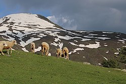 Nani Marg (Maligam) | |
 Pogal Paristan Location in Jammu and Kashmir, India | |
| Coordinates: 33°18′47″N 75°15′43″E / 33.313086°N 75.261806°ECoordinates: 33°18′47″N 75°15′43″E / 33.313086°N 75.261806°E | |
| Country | |
| Union Territory | Jammu and Kashmir |
| District | Ramban |
| Established | 2014 |
| Languages | |
| • Official | Urdu |
| Local Languages | |
| • Spoken | Pogali, Kashmiri, Urdu, Gojri |
| Time zone | UTC+5:30 (IST) |
| Pincode | 182145 |


Pogal Paristan is a valley in the mountains of Jammu Division, in Indian-administered Jammu and Kashmir. Since 2014 its area has constituted a separate tehsil within Ramban district. The valley is situated about 35 kilometers far from District Headquarter Ramban and 23 kilometers from Sub-District Banihal. It is situated in Ramban District in Chenab Valley which is located 150 Kilometers from Jammu making it almost the central point on the national highway (NH-44).
Etymology[]
The name Pogal Paristan is derived from the names of two valleys, the Pogal and Paristan (or Peristan) Valleys. The name Paristan is derived from Muslim folklore. It means land of the peris.[1] Pogal is derived from two words 'pooh' a month in desi calander and 'Gul' means flower. A Local fauna called 'Chhraund' ژریونڈ blooms here in the month of 'pooh'(Dec).
Geography[]
The Pogal Valley lies on the southeast end of Tehsil Banihal, and a stream known as 'Sundari' or 'Pogal stream' runs through it. The Paristan Valley is a narrow valley situated at the southeast end of Tehsil Banihal that runs roughly east to west. Its south side is a forest-covered mountain range of considerable elevation, while the north is a range of mostly bare and stony hills. The path from Kishtwar to Kashmir, by the Nandmarg pass, crosses the Peristan Valley; it is used early in the season before the Brari Bal route becomes usable. A village in the valley named Peristan, which is a part of the Banihal district, lies along this path. It Peristan is located on a spur above the west side of the village of Halan. The valley contains large villages but does contain numerous hamlets and a considerable amount of agricultural cultivation.[1]
About[]
In 2014, Pogal Paristan Tehsil was carved out from Banihal Tehsil. The valley comprises a Block Development Constituency (BDC), 2 District Development Constituencies and 19 Panchayats. There are ten revenue villages in the Tehsil; Pogal, Alinbass, Panchal, Paristan, Bingara, Dhanmasta, Sujmatna, Ramsu,Senabhati and chunthuan.The area is quite hilly.
Economy[]
Inhabitants in Pogal Paristan are mostly agricultural, and grow crops such as Maize, Potatoes, and Pluses (Rajma).[citation needed]
The place has several scenic and valiant niches, i.e. Chapnagla, Pasthati etc.Some most famous tourist spot include Sunaseri , Sharwadhar, Hinjni , Dhoobdanda' Tookra' Hamargali , Kakargali,Googli dhar, Beranbass ,Suliman top in paristan area & Sargali, Rohan Top , Taparwan , Hansraj top in pogal area. but the only thing that requires the most is better road connectivity. If it gets through then it will create ample recourses for the natives to boost the economic constraints.[citation needed]
If this region is promoted under rural tourism, it has the potential to attract a huge footfall of tourists and has the potential of generating local employment to uplift the socio-economic conditions of the natives. Promotion of rural tourism by exposing the tourists to local traditions, handicrafts, architecture, folk dance, folk music etc. can attract a large footfall of from outside. The charming beauty of these scenic spots, along with the simple and healthy lifestyle of local people living in a pure and pollution-free environment in the lap of nature can provide a much-needed respite to the tourist, especially those who live in over congested and polluted cities.[citation needed]
Weather[]
The climate is described as pleasant in the summer and cold and harsh in the winter.[2]
Streams[]
The two major streams in Pogal Paristan are the 'Sundari' or 'Pogal Stream' and the Paristan (or Peristan) stream. The Paritsan (Peristan) stream flows west from its headwaters on a mountain at the north-east end of the valley, while the Sundari (Pogal Stream) flows southwest down the southern slopes of the Nandimarg Mountain, until the two unite upstream of the Paristan (Peristan) Stream's junction with the Bichlari River. The banks of the Paristan (Peristan) Stream are mostly high and steep, especially on its north side. It is bridged just west of the Village of Chiuli. A ford is located a short distance upstream of the bridge, and its possible that there are more in other parts of the river.[1]
References[]
- ^ Jump up to: a b c "Pogal Paristan : Land of Fairies". Travel The Himalayas. 16 July 2019. Retrieved 4 August 2020.
- ^ "Places of Interest". Ramban administration (Government of Jammu and Kashmir). Retrieved 3 August 2020.
External links[]
- Ramban district
- Chenab Valley