Polichni
Polichni
Πολίχνη | |
|---|---|
 Polichni Location within the regional unit 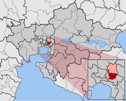 | |
| Coordinates: 40°40′N 22°57′E / 40.667°N 22.950°ECoordinates: 40°40′N 22°57′E / 40.667°N 22.950°E | |
| Country | Greece |
| Administrative region | Central Macedonia |
| Regional unit | Thessaloniki |
| Municipality | Pavlos Melas |
| • Municipal unit | 7.325 km2 (2.828 sq mi) |
| Population (2011)[1] | |
| • Municipal unit | 39,332 |
| • Municipal unit density | 5,400/km2 (14,000/sq mi) |
| Time zone | UTC+2 (EET) |
| • Summer (DST) | UTC+3 (EEST) |

Polichni (Greek: Πολίχνη, literally Little town) is a suburb of the Thessaloniki Urban Area and was a former municipality in the regional unit of Thessaloniki, Greece. Since the 2011 local government reform it is part of the municipality Pavlos Melas, of which it is a municipal unit.[2] The population is 39,332 (2011 census), and it has a land area of 7.325 km2.[3]
The Polichni district includes the areas of:
- Anthokipoi (Gardens)
- Ano Polichni (Upper Polichni)
- Meteora
- Neromiloi (Water Mills)
- St Panteleimon
The central square of Polichni is named after the Saint Panteleimon church.
External links[]
- Official website (in Greek)
References[]
- ^ a b "Απογραφή Πληθυσμού - Κατοικιών 2011. ΜΟΝΙΜΟΣ Πληθυσμός" (in Greek). Hellenic Statistical Authority.
- ^ "ΦΕΚ B 1292/2010, Kallikratis reform municipalities" (in Greek). Government Gazette.
- ^ "Population & housing census 2001 (incl. area and average elevation)" (PDF) (in Greek). National Statistical Service of Greece.
This Central Macedonia location article is a stub. You can help Wikipedia by . |
Categories:
- Populated places in Thessaloniki (regional unit)
- Central Macedonia geography stubs