Poltava Raion
Poltava Raion
Полтавський район | |
|---|---|
Raion | |
 Flag  Coat of arms | |
 | |
| Coordinates: 49°35′0.423″N 34°36′30.4524″E / 49.58345083°N 34.608459000°ECoordinates: 49°35′0.423″N 34°36′30.4524″E / 49.58345083°N 34.608459000°E | |
| Country | |
| Region | Poltava Oblast |
| Established | March 7, 1923 |
| Admin. center | Poltava |
| Subdivisions | 24 hromadas |
| Government | |
| • Governor | Lidia Lepeyko |
| Area | |
| • Total | 1,259 km2 (486 sq mi) |
| Population (2021)[1] | |
| • Total | 589,922 |
| • Density | 470/km2 (1,200/sq mi) |
| Time zone | UTC+02:00 (EET) |
| • Summer (DST) | UTC+03:00 (EEST) |
| Postal index | 38701—38786 |
| Area code | +380-5322 |
| Website | Official homepage |

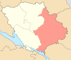
Poltava Raion (Ukrainian: Полтавський район) is a raion (district) in Poltava Oblast of central Ukraine. The raion's administrative center is the city of Poltava. Population: 589,922 (2021 est.)[1]
On 18 July 2020, as part of the administrative reform of Ukraine, the number of raions of Poltava Oblast was reduced to four, and the area of Poltava Raion was significantly expanded. [2][3] The January 2020 estimate of the raion population was 68,174 (2020 est.)[4]
References[]
- ^ a b "Чисельність наявного населення України (Actual population of Ukraine)" (PDF) (in Ukrainian). State Statistics Service of Ukraine. Retrieved 11 July 2021.
- ^ "Про утворення та ліквідацію районів. Постанова Верховної Ради України № 807-ІХ". Голос України (in Ukrainian). 2020-07-18. Retrieved 2020-10-03.
- ^ "Нові райони: карти + склад" (in Ukrainian). Міністерство розвитку громад та територій України.
- ^ "Чисельність наявного населення України (Actual population of Ukraine)" (PDF) (in Ukrainian). State Statistics Service of Ukraine. Retrieved 30 September 2020.
This article about a location in Poltava Oblast is a stub. You can help Wikipedia by . |
Categories:
- Raions of Poltava Oblast
- Poltava Oblast geography stubs