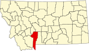
Ponderosa Pines, Montana
Ponderosa Pines, Montana | |
|---|---|
 Ponderosa Pines | |
| Coordinates: 46°1′56″N 111°22′2″W / 46.03222°N 111.36722°WCoordinates: 46°1′56″N 111°22′2″W / 46.03222°N 111.36722°W | |
| Country | United States |
| State | Montana |
| County | Gallatin |
| Area | |
| • Total | 39.51 sq mi (102.33 km2) |
| • Land | 39.5 sq mi (102.3 km2) |
| • Water | 0.01 sq mi (0.03 km2) |
| Elevation | 4,354 ft (1,327 m) |
| Population (2010) | |
| • Total | 336 |
| • Density | 8.5/sq mi (3.3/km2) |
| Time zone | UTC-7 (Mountain (MST)) |
| • Summer (DST) | UTC-6 (MDT) |
| Area code(s) | 406 |
| GNIS feature ID | 2583834[1] |
Ponderosa Pines is a census-designated place (CDP) in Gallatin County, Montana, United States. The population was 336 at the 2010 census.[2] Formerly a 13,000-acre ranch, the land was subdivided into 10- and 20-acre parcels and sold by a Hawaii real estate agency starting in 1972. The lots lacked water, sewer, electricity and road access, and some were on such steep terrain that building would be impossible.[3]
References[]
- ^ U.S. Geological Survey Geographic Names Information System: Ponderosa Pines, Montana
- ^ "U.S. Census website". United States Census Bureau. Retrieved 2011-05-14.
- ^ Porter, Kenneth F.; Torgrimson, Tina (January 1974). "Ponderosa Pines Ranch: A Subdivision Case Study" (PDF). State of Montana Environmental Quality Council. Retrieved 7 November 2021.
{{cite web}}: CS1 maint: url-status (link)
Categories:
- Census-designated places in Gallatin County, Montana
- Census-designated places in Montana
- Montana geography stubs


