Port of Gaza
| Port of Gaza | |
|---|---|
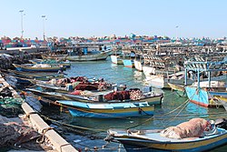 Gaza port, 2015 | |
 | |
| Location | |
| Country | State of Palestine |
| Location | Gaza Governorate, Gaza Strip |
| Coordinates | 31°31′33″N 34°25′50″E / 31.52583°N 34.43056°E |
| Grid position | 096/104 PAL |
| UN/LOCODE | PSGZA[1] |
| Details | |
| Operated by | Palestinian National Authority |
| Land area | 48,000 m2 (520,000 sq ft) |
| Piers | 970 and 330 m (3,180 and 1,080 ft) |

The Port of Gaza is a small port near the Rimal district of Gaza City.[2] It is the home port of Palestinian fishing-boats and the base of the Palestinian Naval Police, a branch of the Palestinian National Security Forces. Under the Oslo II Accord, the activities of the Palestinian Naval Police are restricted to 6 nautical miles from the coast.[3] Since 2007, the Port of Gaza has been under an Israeli-imposed naval blockade as part of a blockade of the Gaza Strip, and activities at the port have been restricted to small-scale fishing.
History[]
Gaza Strip[]
The Gaza strip has been put under a strict siege, by land, air, and sea.[4] The total surface area of 362 square kilometers,[5] owns a main poor transportation system that only has 76km of main roads, 122km of regional roads, and 99km of local roads.[4] The strip had a small airport located at Rafah, which was destroyed in 2001 by Israeli.[4] The port was built by the Palestinian National Authority (PNA).[4]
Maiuma[]
In earlier times, the port of Maiuma, or el Mineh (meaning "the harbour"), was located in the area.[6] In the late Ottoman era, Pierre Jacotin named the place Majumas on his map from 1799.[7]
In 1883, the PEF's Survey of Western Palestine (SWP) noted that el Mineh was probably the ancient Maiuma.[8]
In 2011, eight Roman columns believed to be the remains of a church were swept ashore during a storm.[9] In 2013, the Palestinian Naval Police found ancient artifacts that included poles and baked clay.[10]
Since 1994[]
In 2002, Israeli forces attacked the Palestinian Naval Police facilities in the port,[11] after Naval Police commanders were implicated in the Karine A affair, an attempt to secretly bring in 50 tons of weapons by boat into Gaza.
In 2007, following Hamas' takeover of Gaza, Israel imposed a blockade of the Gaza Strip, including a naval blockade.[12] Several attempts to break the Israeli blockade have been made.[13] Israel has prevented most ships from docking at the Port of Gaza, but did allow two boats, carrying activists and some supplies, to reach the port in 2008.[14] As at 2010, the port was restricted to smaller Palestinian fishing boats.[15]
In 2010, the port was deepened by Hamas in preparation for the arrival of a blockade-breaking flotilla of larger international ships.[15] A breakwater was constructed and lighting was installed. Hamas announced plans to develop the port to make it more accessible to fishermen and attract tourists.
Gaza Seaport plans[]

Since the 1993 Oslo I Accord, there have been plans to build a much larger seaport in Gaza. Due to the continuing Israeli–Palestinian conflict, these plans have not materialized as of 2014.
In 2005, Israel approved Palestinian plans to rebuild and complete the construction of a port a few miles south of Gaza City, which had begun before the outbreak of the Second Intifada in September 2000. The building was destroyed by Israeli forces together with Gaza's existing airport near Rafah following the outbreak of the Second Intifada.[16]
References[]
- ^ "UNLOCODE (PS) - PALESTINE, STATE OF". service.unece.org. Retrieved 25 April 2020.
- ^ Doughty and El Aydi, 1995, p. 13
- ^ Karsh, Efraim (2013). Israel: the First Hundred Years: Volume II: From War to Peace?. p. 216.
- ^ a b c d Sarraj, Yahya R. (2018-11-14). "Hourly and Daily Traffic Expansion Factors on Selected Roads in Gaza, Palestine". The Open Civil Engineering Journal. 12 (1): 355–367. doi:10.2174/1874149501812010355. ISSN 1874-1495.
- ^ Zavadjil, Milan (1997-02-28). Recent Economic Developments, Prospects, and Progress in Institution Building in the West Bank and Gaza Strip. INTERNATIONAL MONETARY FUND. doi:10.5089/9781557756381.071. ISBN 978-1-55775-638-1.
- ^ Palmer, 1881, p. 361
- ^ Karmon, 1960, p. 173
- ^ Conder and Kitchener, 1883, SWP III, p. 236
- ^ Gaza's archaeological treasures at risk from war and neglect 7 January 2013, BBC
- ^ Israeli navy attacks Gaza port, 12 January 2002, BBC
- ^ Israeli navy blocks Gaza aid ship, 1 December 2008, The Guardian
- ^ U.S. leftists confirm plans to sail to Gaza to break siege 29 July 2008 U.S. Haaretz
- ^ Navy lets another boat into Gaza port, by Yaakov Katz and Herb Keinon 9 December 2008, The Jerusalem Post
- ^ a b Gaza port readies for flotilla, May 27, 2010, Jerusalem Post
- ^ Palestinians to rebuild Gaza sea port in latest peace move, Anton La Guardia, 17 February 2005, The Daily Telegraph
Bibliography[]
- Conder, C.R.; Kitchener, H.H. (1883). The Survey of Western Palestine: Memoirs of the Topography, Orography, Hydrography, and Archaeology. 3. London: Committee of the Palestine Exploration Fund.
- Doughty, Dick; El Aydi, Mohammed (1995). Gaza: legacy of occupation--a photographer's journey. Kumarian Press. ISBN 1-56549-044-4.
- Karmon, Y. (1960). "An Analysis of Jacotin's Map of Palestine" (PDF). Israel Exploration Journal. 10 (3, 4): 155–173, 244–253.
- Palmer, E.H. (1881). The Survey of Western Palestine: Arabic and English Name Lists Collected During the Survey by Lieutenants Conder and Kitchener, R. E. Transliterated and Explained by E.H. Palmer. Committee of the Palestine Exploration Fund.
External links[]
- Photos of the Port and the Sea of Gaza on Facebook
- Survey of Western Palestine, Map 19: IAA, Wikimedia commons
Coordinates: 31°31′30.77″N 34°25′51.84″E / 31.5252139°N 34.4310667°E
- Buildings and structures in the Gaza Strip
- Ports and harbours of the Mediterranean
- Nabataea
- History of the Arabian Peninsula
- History of Palestine (region)
- Ports and harbours of the State of Palestine