Portlaw
This article needs additional citations for verification. (September 2014) |
Portlaw
Irish: Port Lách | |
|---|---|
Town | |
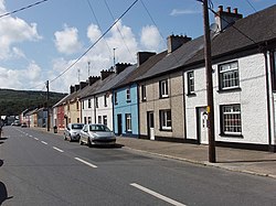 Main street of Portlaw | |
 Portlaw Location in Ireland | |
| Coordinates: 52°17′20″N 7°18′53″W / 52.288921°N 7.3146200°W | |
| Country | Ireland |
| Province | Munster |
| County | Waterford |
| Elevation | 40 m (130 ft) |
| Population (2016)[1] | |
| • Total | 1,742 |
| Time zone | UTC+0 (WET) |
| • Summer (DST) | UTC-1 (IST (WEST)) |
| Irish Grid Reference | S468154 |

Portlaw (Irish: Port Cládach or Port Lách) is a town in County Waterford, Ireland. It is also a parish in the Roman Catholic Diocese of Waterford and Lismore. It is situated some 19 km west-north-west of Waterford City, where the Clodiagh meets the Suir.
History[]
It was once the home of a very successful cotton mill employing most of the town's population. The mill was built by the Malcomson family. The Malcomsons were a Quaker family, and their religious ideals impacted greatly on the town, with industrial houses and social networks built as part of the planned town still forming a central part of the streetscape today. The Malcomsons were one of the most influential families connected to Irish planned industrial towns, through marriage they became connected to Quakers who designed Bessbrook in Northern Ireland, with Portlaw truss roofs being built into Bessbrook houses as a result.[citation needed]
Amenities[]
The town's main street has a bakery, butcher, grocery, bars, a heritage centre and Roman Catholic and Church of Ireland churches.
Curraghmore House, sitting on the outskirts of the town, is a manor house surrounded by 40 ha of land. It has been opened to visitors by Henry Beresford, 9th Marquess of Waterford.[citation needed] It hosts annual tourist and charity events, such as the Bluebell Festival.[citation needed]
Transport[]
Suirway operate a bus route linking Portlaw to Waterford.[7] Until 1963 there was a railway station at Fiddown on the Waterford to Limerick railway line which was also known as Fiddown & Portlaw.[citation needed]
See also[]
- List of towns and villages in Ireland
References[]
- ^ "Sapmap Area: Settlements Portlaw". Census 2016. Central Statistics Office. 2016. Archived from the original on 14 February 2018. Retrieved 13 February 2018.
- ^ "Census for post 1821 figures". Archived from the original on 9 March 2005. Retrieved 1 August 2009.
- ^ Irish population infosite Archived 7 May 2016 at the Wayback Machine, histpop.org; accessed 21 September 2014.
- ^ Census information Archived 17 February 2012 at the Wayback Machine, nisranew.nisra.gov.uk; accessed 21 September 2014.
- ^ Lee, JJ (1981). "On the accuracy of the Pre-famine Irish censuses". In Goldstrom, J.M.; Clarkson, L. A. (eds.). Irish Population, Economy, and Society: Essays in Honour of the Late K. H. Connell. Oxford, England: Clarendon Press.
- ^ Mokyr, Joel; O Grada, Cormac (November 1984). "New Developments in Irish Population History, 1700-1850". The Economic History Review. 37 (4): 473–488. doi:10.1111/j.1468-0289.1984.tb00344.x. hdl:10197/1406.[dead link]
- ^ http://www.suirway.com/timetables-portlaw.html#portlaw_annual[bare URL]
External links[]
| Wikimedia Commons has media related to Portlaw. |
| show Places in County Waterford |
|---|

| show Authority control |
|---|
- Towns and villages in County Waterford
- Geography of County Waterford
- Parishes of the Roman Catholic Diocese of Waterford and Lismore