Potaro-Siparuni
Potaro-Siparuni
Region 8 | |
|---|---|
Administrative Region | |
 | |
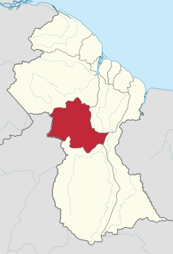 Map of Guyana showing Potaro-Siparuni region | |
| Country | |
| Regional Capital | Mahdia |
| Area | |
| • Total | 20,051 km2 (7,742 sq mi) |
| Population (2012 census) | |
| • Total | 10,190 |
| • Density | 0.51/km2 (1.3/sq mi) |
| [2] | |
Potaro-Siparuni (Region 8) is a region of Guyana. Venezuela claims the majority of the Region located west of the Essequibo River as part of Guayana Esequiba.
It borders the region of Cuyuni-Mazaruni to the north, the regions of Upper Demerara-Berbice and East Berbice-Corentyne to the east, the region of Upper Takutu-Upper Essequibo to the south and Brazil to the west.
The main villages in the region are Campbelltown, Orinduik, Mahdia, Paramakatoi and Tumatumari.
Population[]
The Government of Guyana has administered three official censuses since the 1980 administrative reforms, in 1980, 1991 and 2002.[3] In 2012, the population of Potaro-Siparuni was recorded at 10,190 people.[4] Official census records for the population of Potaro-Siparuni are as follows:

- 2012 : 10,190
- 2002 : 10,095
- 1991 : 5,616
- 1980 : 4,485
Communities[]
(including name variants):[5]
- Arnik Village
- Campbelltown
- Itabac
- Kamana Village
- Kanapang Village
- Kato (Kato Village, Karto)
- Kopinang Mission
- Mahdia
- Micobie
- Monkey Mountain
- Orinduik
- Paramakatoi (Paramahatoi)
- Potaro Landing
- Taruka
- Tumatumari
- Tumatumari Landing
- Waipa Village
See also[]
References[]
- ^ "Official Announcements". Archived from the original on 8 September 2016. Retrieved 28 July 2016.
- ^ Macmillan Publishers (2009). "Administrative Regions - 8, 9 and 10". Macmillan Junior Atlas: Guyana. Oxford: Macmillan Caribbean. p. 37. ISBN 9780333934173.
- ^ Beaie, Sonkarley Tiatun (19 September 2007). "Chapter 3: National Redistribution and Internal Migration" (PDF). 2002 Population and Housing Census - Guyana National Report. Bureau of Statistics. p. 51. Archived from the original (PDF) on 24 November 2007. Retrieved 29 August 2012.
- ^ Beaie, Sonkarley Tiatun (19 September 2007). "National Population Trends: Size, Growth and Distribution" (PDF Download). 2002 Population and Housing Census - Guyana National Report. Bureau of Statistics. p. 25. Retrieved 29 August 2012.
- ^ "2012 Population by Village". Statistics Guyana. Retrieved 8 December 2021.
Coordinates: 4°46′11″N 59°15′55″W / 4.769702°N 59.265391°W

- Potaro-Siparuni
- Regions of Guyana